Kodikuthimala
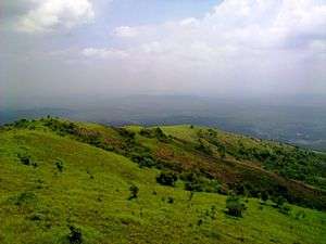
Kodikuthimala also known as the Ooty of Malappuram [1] is a hill station in the Malappuram district of Kerala in India. Located in Vettathur and Thazhekode villages, at a height of 522 m above sea level, this is the highest geographic peak in Amminikkadan hills.
| Kodikuthimala | |
|---|---|
 | |
| Highest point | |
| Elevation | 522 m (1,713 ft) |
| Geography | |
| Location | Perinthalmanna taluk , Malappuram district, Kerala, India |
| Parent range | Amminikkadan Hills |
| Climbing | |
| Easiest route | From Perinthalmanna, via Amminikkad |
There are 5 largest mountains in Kerala except the Western Ghats.
Three of them are in Malappuram district, one in Palakkad and one in Kannur.It is the second highest mountain in Malappuram district in terms of height.
The British hoisted their flag on this hilltop during a survey, thus getting the name Kodikuthimala. It is almost two decades ago that the hilltop started featuring on the tourism map of Kerala. Around 70 acres of land in this area is earmarked by the Tourism Department for various projects. Kodikuthimala, at an altitude of 1,713-ft above sea level, has a watch tower that is visited by tourists because of the vantage point it offers.
Trekking to the top of Kodikuthimala is a challenging task due to the varied topography of the hill.
The most common time to visit Kodikuthimala is between September to May. It is located 66 km from Palakkad.32 km from Malappuram, 9 km from Perintalmanna and 82 km from Calicut.[1]
References
- "The Ooty Of Malappuram-Kodikuthimala". Deccan Chronicle. 18 April 2014. Retrieved 8 August 2018.
External links
| Wikimedia Commons has media related to Kodikuthimala. |