Klondike, Kenosha County, Wisconsin
Klondike is an unincorporated community residential and agricultural community in the town of Brighton, in Kenosha County, Wisconsin, United States.[1]
Klondike, Wisconsin | |
|---|---|
 Klondike  Klondike | |
| Coordinates: 42°35′24″N 88°07′10″W | |
| Country | United States |
| State | Wisconsin |
| County | Kenosha |
| Town | Brighton |
| Elevation | 833 ft (254 m) |
| Time zone | UTC-6 (Central (CST)) |
| • Summer (DST) | UTC-5 (CDT) |
| Area code(s) | 262 |
| GNIS feature ID | 1567552[1] |
History
Klondike was first settled in the 19th century and was formerly known as "Klondike Corner". It is centered at Highway 75 and 52nd Street (Kenosha County Highway NN). The Union League Camp facility, which houses an Army Reserve enrichment program, is located on 244th Avenue at 52nd Street in Klondike. Until July 20, 1941, when the Union League Club of Chicago took over the site, it had been a communist youth camp called Camp Nitgedeiget (meaning "don't worry" in Yiddish) where the Third Internationale had been sung and a hammer and sickle flag was raised daily.[2][3][4]
Notes
- "Klondike, Wisconsin". Geographic Names Information System. United States Geological Survey.
- Racine Journal-Tribune, July 22, 1941, pg. 7
- "Klondike website". Archived from the original on 2007-09-27. Retrieved 2006-06-16.
- Kenohas County, WI Place Names
Municipalities and communities of Kenosha County, Wisconsin, United States | ||
|---|---|---|
| City | 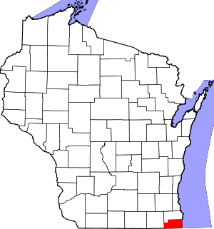 | |
| Villages | ||
| Towns | ||
| CDPs | ||
| Neighborhoods and unincorporated communities | ||
| Footnotes | ‡This populated place also has portions in an adjacent county or counties | |
This article is issued from Wikipedia. The text is licensed under Creative Commons - Attribution - Sharealike. Additional terms may apply for the media files.