Kings River (Nevada)
The Kings River is a tributary of the Quinn River, about 40 mi (64 km) long, in northwestern Nevada and south-central Oregon in the United States.[1] It drains a remote arid area of the northwestern Great Basin.[3]
| Kings River | |
|---|---|
 Quinn River watershed, including Kings River watershed | |
| Location | |
| Country | United States |
| State | Nevada, Oregon |
| Physical characteristics | |
| Source | west of Disaster Peak |
| • location | The Granites, Humboldt County, Nevada, Nevada |
| • coordinates | 41°59′05″N 118°13′36″W[1] |
| • elevation | 8,382 ft (2,555 m)[2] |
| Mouth | Quinn River |
• location | Quinn River Lakes, Humboldt County, Nevada, Nevada |
• coordinates | 41°30′54″N 118°08′55″W[1] |
• elevation | 4,114 ft (1,254 m)[1] |
| Length | 40 mi (64 km)[3] |
Description
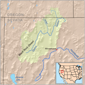
The river rises in northern Hunboldt County, Nevada west of Disaster Peak in The Granites, part of the Trout Creek Mountains, near the Oregon state line. Flowing northwest, it crosses briefly into Harney County, Oregon, then turns sharply south and re-enters Humboldt County for the rest of its course. It flows generally south between the Bilk Creek Mountains on the right (west) and the Montana Mountains, then the Double H Mountains on the left. It joins the Quinn River from the north at Quinn River Lakes. The Quinn River flows southwest from the lake to end in a sink in the Black Rock Desert west of Winnemucca.[3]
References
- U.S. Geological Survey Geographic Names Information System: Kings River
- Source elevation derived from Google Earth search using GNIS source coordinates.
- Nevada Road and Recreation Atlas (Map). Benchmark Maps. 2007. § 32. Distances estimated via map scale and ruler.