Kikai Caldera
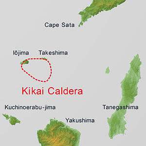
Kikai Caldera (鬼界カルデラ, Kikai karudera) is a massive, mostly submerged caldera up to 19 kilometres (12 mi) in diameter in the Ōsumi Islands of Kagoshima Prefecture, Japan.
| Kikai Caldera | |
|---|---|
 | |
| Highest point | |
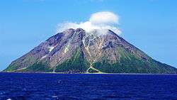
| Peak | Mount Iō (Iōjima), Iōjima, Ōsumi Islands, Japan |
| Elevation | 704 m (2,310 ft) |
| Coordinates | 30°47′N 130°19′E [1] |
| Dimensions | |
| Length | 17 km (11 mi) NS |
| Width | 20 km (12 mi) EW |
| Naming | |
| Native name | 鬼界カルデラ |
| Geography | |
| Country | Japan |
| State | Kagoshima Prefecture |
| Region | Ōsumi Islands |
| District | Kagoshima District |
| Municipality | Mishima |
| Subdivisions | List
|
| Geology | |
| Age of rock | 6,300 to 95,000 years ago |
Kikai Caldera was the source of the Akahoya eruption, the second-largest eruption in recorded history and one of the largest eruptions during the Holocene (10,000 years ago to present). About 6,300 years ago or 4,300 BC, pyroclastic flows from that eruption reached the coast of southern Kyūshū up to 100 km (62 mi) away, and ash fell as far as Hokkaidō. The eruption produced about 150 km³ of tephra,[2] giving it a Volcanic Explosivity Index of 7[3] and making it one of the most explosive in the last 10,000 years, ranking alongside Santorini, Changbaishan, Crater Lake, Kurile Lake and Tambora.[4]
Kikai is still an active volcano. Minor eruptions occur frequently on Mount Iō, one of the post-caldera subaerial volcanic peaks on Iōjima. Iōjima is one of three volcanic islands, two of which lie on the caldera rim. On June 4, 2013, weak tremors were recorded. Shortly after, eruptions began and continued off-and-on for several hours.[5]
According to ice cores, the Akahoya eruption may have occurred 4350 BC.[6]
Further reading
- Machida, Hiroshi; Sugiyama, Shinji (2002). "The impact of the Kikai-Akahoya explosive eruptions on human societies". In Grattan, John; Torrence Robin (eds.). Natural Disasters and Cultural Change. London: Routledge. pp. 313–346. ISBN 0-415-21696-6.
See also
References
- "Kikai". Global Volcanism Program. Smithsonian Institution.
- "KIKAI Caldera". Quaternary Volcanoes in Japan. Geological Survey of Japan, AIST. 2006. Archived from the original on 2012-12-19. Retrieved 2009-01-08.
- VolcanoWorld – Kikai, Kyūshū, Japan
- 鬼界カルデラ Kikai Caldera 独立行政法人 産業技術総合研究所 地 質 調 査 総 合 セ ン タ ー
- Kikai Caldera – Volcano Photos
- "Kikai | Volcano World | Oregon State University". volcano.oregonstate.edu. Retrieved 2017-04-11.
- Kikai – Eruptive history, Global Volcanism Program. Smithsonian Institution.
- Johnston, Eric, "Latest volcano show: Shinmoe", The Japan Times, 1 March 2011, p. 3.
- "Large Volcano Explocivity Index". Countries of the World. Retrieved 2014-04-24.
- "Global Volcanism Program | Kikai". volcano.si.edu. Retrieved 2017-04-07.
- Zielinski, G. A.; Mayewski, P. A.; Meeker, L. D.; Whitlow, S.; Twickler, M. S.; Morrison, M.; Meese, D. A.; Gow, A. J.; Alley, R. B. (1994-05-13). "Record of Volcanism Since 7000 B.C. from the GISP2 Greenland Ice Core and Implications for the Volcano-Climate System". Science. 264 (5161): 948–952. Bibcode:1994Sci...264..948Z. doi:10.1126/science.264.5161.948. ISSN 0036-8075. PMID 17830082.
External links
- Satsuma-iojima - Geological Survey of Japan
- Kikai - Geological Survey of Japan
- Geology and eruptive history of Kikai Caldera - Earthquake Research Institute,The University of Tokyo
- Kikai: Global Volcanism Program- Smithsonian Institution