Khorugh
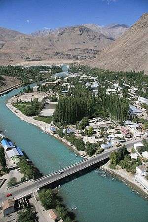
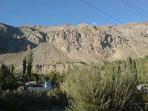
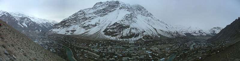
The town of Khorugh (Tajik: Хоруғ)[lower-alpha 1] is the capital of the Gorno-Badakhshan (Tajik: Кӯҳистони Бадахшон, Köhistoni Badaxshon, "Badakhshan Mountainous Region") Autonomous Region (GBAO) in Tajikistan. It is also the capital of the Shughnon District of Gorno-Badakhshan. It has a population of 28,000 (2000 census). Khorugh is 2,200 metres (7,200 ft) above sea level in the Pamir Mountains (ancient Mount Imeon) at the confluence of the Gunt and Panj rivers. The city is bounded to the south (Nivodak) and to the north (Tem) by the deltas of the Shakhdara and Gunt, respectively. The two rivers merge in the eastern part of the city flow through the city, dividing it almost evenly until its delta in the Panj River, also being known as Amu Darya, or in antiquity the Oxus) on the border with Afghanistan. Khorugh is known for its poplar trees that dominate the flora of the city.
Khorugh Хоруғ | |
|---|---|
 | |
 Seal | |
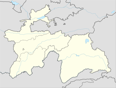 Khorugh Location of Khorugh in Tajikistan | |
| Coordinates: 37°29′30″N 71°33′21″E | |
| Country | |
| Province | Gorno-Badakhshan Autonomous Region |
| District | Shughnon District |
| Elevation | 2,123 m (6,965 ft) |
| Population (2003) | |
| • Total | 30,000 |
| Time zone | GMT+5 |
| Area code(s) | +992 3522 |
| Climate | BSk |
History
Until the late 19th century, Khorugh was in an area disputed between the Emir of Bukhara, Shah of Afghanistan, Russia and Britain. The Russians emerged the winners of the region after The Great Game, which fixed the current northern border of Afghanistan on the Panj River and established the territory of Russian Pamir around Khorugh.
Before 1896, when the Russians arrived and built a fort, the main town in the area was Kala-i Bar Panj (or Bar Panja Qal'a) somewhat downriver on the Afghan side. Following the fall of czarist Russia and the rise of the Soviet Union, Khorugh became the capital of Gorno-Badakhshan in 1925. Soviet leaders encouraged the migration of settlers to the area with promises of pay, medals and automobiles, but with no industry and little arable land, the effort was not successful.
Khorugh occupied headlines in July 2012 due to a government forces clash with guerrillas. Over 40 people, including 12 soldiers were killed (many reports indicated that the number of casualties could be higher). The country’s security forces moved in to arrest suspects in the murder of secret services General Abdullo Nazarov. The alleged criminals were linked to former guerrilla leader-turned-border patrol commander Tolib Ayombekov. Ayombekov is alleged to have been involved in drug trafficking and the smuggling of tobacco and precious stones for many years.[1]
Facilities and Education
Modern Khorugh is one of the poorest areas of Tajikistan, with the charitable organization Aga Khan Foundation providing almost the only source of cash income. However, the city does have its own university (Khorugh State University), founded in 1992), twelve schools, and several hospitals. There is a museum, the Khorog Regional Museum,[2] an Ismaili Centre[3], and the second-highest botanical garden in the world, the Pamir Botanical Garden.[4][5]
Khorugh is also host to the Aga Khan Lycée, one of three campuses of the University of Central Asia (UCA). The University was founded in 2000 by the governments of Kazakhstan, the Kyrgyz Republic and Tajikistan, and The Aga Khan. It is the world’s first internationally chartered institution of higher education. The UCA currently operates a School of Professional and Continuing Education(SPCE), with a School of Arts and Sciences and a Graduate School of Development in the process of being established. The Khorog Campus offers Bachelor of Arts and Bachelor of Science degrees in Economics and Earth and Environmental Sciences.[6]
Transportation
There is a bridge to the Afghan side of the river. Khorugh is situated along the Pamir Highway at the point where it leaves the Panj valley and heads east up the Gunt valley. The Pamir highway is the main road in Gorno-Badakhshan and connects the Tajik capital of Dushanbe toward the west to the Republic of Kyrgyzstan to the northeast.
The highway is very difficult to pass in both directions, especially during winter and spring. Khorugh also has a small airport, which can accommodate small capacity airplanes like AN-28 turboprop and the Yakovlev YAK-40 or helicopters.
Climate
Khorugh experiences a semi-arid climate (Köppen climate classification BSk) with cold, relatively wet winters and hot, dry summers.
| Climate data for Khorugh (1961–1990, extremes 1898–present) | |||||||||||||
|---|---|---|---|---|---|---|---|---|---|---|---|---|---|
| Month | Jan | Feb | Mar | Apr | May | Jun | Jul | Aug | Sep | Oct | Nov | Dec | Year |
| Record high °C (°F) | 11.8 (53.2) |
12.6 (54.7) |
21.6 (70.9) |
30.0 (86.0) |
36.2 (97.2) |
38.2 (100.8) |
37.9 (100.2) |
38.2 (100.8) |
39.7 (103.5) |
29.5 (85.1) |
20.5 (68.9) |
14.0 (57.2) |
39.7 (103.5) |
| Average high °C (°F) | −1.2 (29.8) |
0.6 (33.1) |
6.8 (44.2) |
15.7 (60.3) |
21.4 (70.5) |
26.6 (79.9) |
30.1 (86.2) |
30.4 (86.7) |
26.1 (79.0) |
18.2 (64.8) |
9.5 (49.1) |
2.3 (36.1) |
15.5 (59.9) |
| Average low °C (°F) | −11.2 (11.8) |
−8.9 (16.0) |
−1.7 (28.9) |
5.2 (41.4) |
8.6 (47.5) |
12.1 (53.8) |
15.2 (59.4) |
15.1 (59.2) |
9.9 (49.8) |
4.1 (39.4) |
−1.1 (30.0) |
−6.5 (20.3) |
3.4 (38.1) |
| Record low °C (°F) | −27.1 (−16.8) |
−26.6 (−15.9) |
−19.8 (−3.6) |
−7.6 (18.3) |
−1.3 (29.7) |
1.9 (35.4) |
7.4 (45.3) |
5.4 (41.7) |
1.5 (34.7) |
−14.0 (6.8) |
−13.2 (8.2) |
−24.7 (−12.5) |
−27.1 (−16.8) |
| Average precipitation mm (inches) | 33.8 (1.33) |
35.5 (1.40) |
45.6 (1.80) |
42.2 (1.66) |
29.9 (1.18) |
8.4 (0.33) |
3.4 (0.13) |
1.4 (0.06) |
1.0 (0.04) |
5.6 (0.22) |
7.5 (0.30) |
11.5 (0.45) |
225.8 (8.89) |
| Average precipitation days | 11.5 | 13.2 | 16.4 | 13.5 | 12.2 | 5.7 | 3.7 | 1.4 | 1.0 | 5.6 | 7.5 | 11.5 | 103.2 |
| Average relative humidity (%) | 72.2 | 70.7 | 61.8 | 51.6 | 52.8 | 48.0 | 43.9 | 40.7 | 43.8 | 54.3 | 60.1 | 64.9 | 55.4 |
| Mean monthly sunshine hours | 108 | 103 | 139 | 178 | 223 | 262 | 269 | 275 | 245 | 181 | 144 | 105 | 2,232 |
| Source 1: World Meteorological Organisation (average high and low/precipitation/precipitation days 1961–1990),[7] NOAA (sun 1961–1990)[8] | |||||||||||||
| Source 2: climatebase.ru (humidity),[9] Meteo Climat (record highs and lows)[10] | |||||||||||||
Photo gallery

Notes
- also transliterated as Horog, Khoroq, Khorogh, Khorog, or Xoroq
References
- "Government Forces Clash with Guerrillas in Tajikistan". The Gazette of Central Asia. Satrapia. 24 Jul 2012. Retrieved 4 August 2012.
- "Regional Museum". lonelyplanet.com. Retrieved 4 February 2018.
- "Khorog Travel Guide". Caravanistan. Retrieved 2019-07-06.
- "Pamir Botanical Garden". lonelyplanet.com. Retrieved 2 February 2018.
- "Pamir Botanical garden". traveltajikistan.net. Retrieved 4 February 2018.
- "Undergraduate Programme - University of Central Asia". www.ucentralasia.org. Retrieved 2016-10-10.
- "World Weather Information Service – Khorog". World Meteorological Organization. Retrieved 18 December 2019.
- "Horog (Khorog) Climate Normals 1961–1990". National Oceanic and Atmospheric Administration. Retrieved 18 December 2019.
- "Khorog,Tajikistan". Climatebase.ru. Retrieved 1 February 2013.
- "Station Khorog" (in French). Meteo Climat. Retrieved 18 December 2019.
- Фоминых, Борис (15 January 2011). "Опубликован календарь матчей турнира по хоккею с мячом Азиады-2011" (in Russian). Bandynet. Retrieved 21 February 2015.
External links
| Wikivoyage has a travel guide for Khorugh. |
- Gorgâni, Tirdâd (May 2005)."Welcome to Xoroq (Khorogh)" (web archive, 1 August 2008).
- Tourist Information Office in Khorog Pamirs Tourism Association
- A great homepage on the Tajik Pamirs
- Airport of Khorugh.
- A Bird's Eye View of Khorog
| Districts |  | |
|---|---|---|
| Main cities and towns | ||
| Geography |
| |