Khed, Ratnagiri
Khed is a town with a municipal council in the Ratnagiri district of the state of Maharashtra, India. Situated on the Mumbai - Goa Highway, NH 66, it is surrounded by a number of villages.
Khed | |
|---|---|
town | |
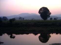 Naringi River, which flows through Khed | |
 Khed Location in Maharashtra, India  Khed Khed (Maharashtra) | |
| Coordinates: 17°43′04″N 73°23′38″E | |
| Country | |
| State | Maharashtra |
| District | Ratnagiri |
| Elevation | 25 m (82 ft) |
| Population (2011) | |
| • Total | 16,892 |
| Demonym(s) | Khedkar |
| Languages | |
| • Official | Marathi |
| Time zone | UTC+5:30 (IST) |
| PIN | 415709 |
| Sex ratio | 0.96 ♂/♀ |
| Literacy | 80% |
| Khed is situated in Mumbai–Goa National Highway No. 66 | |
Khed is the headquarters of Khed taluka which connects the district administration with the village administration.
Geography
Khed is located at 17.72°N 73.38°E.[1] It has an average elevation of 25 metres (82 feet). Alphonso mangoes are grown in the area around the town. Khed lies between Kashedi Ghat and Bhoste Ghat. The region surrounding the town is mostly mountainous.
The Jagbudi River is a large river located in the area. Raghuveer ghat is mainly use for picnic spots.
Culture
Khed is a town that has many festivities. Several religious festivals are celebrated in the town. Social groups like Navnirman Kala Sanstha have been promoting artists from surrounding villages to show [their work] at state and national levels since 2004.
Eid is celebrated by the Muslim population.
'RAJ YUVA Mahostav' & 'JCI festival' (mela) is also organized in Khed once every year.
Shimaga (Holi) [and] Ganapati are Konkan's favorite festivals. Gauri-Ganpati festival is celebrated with cheer and enthusiasm all over the taluka.
Ram Navmi festival is celebrated in Laxmi Narayan Temple. It is celebrated for 10 days starting from Gudi Padva.
Ganeshoostav is largely and joyfully celebrated in the city.
One of the most important attractions of Khed is the annual rally conducted on the occasion of SHIVJAYANTI.
Also KHED is known for huge rally conduction on the occasion of EID MILADUNNABI (Mawlid) in all over Ratnagiri district.
Food
Vada-Pav is a popular snack in this city. Vade-Mutton is a popular dish in the khed. The staple diet is rice and fish. Ghavane is one of the main dishes in the menu which prepared by the rice flour, eaten as Breakfast. Also, Monga is a famous food item called as "Popati" in north konkan.
Places to visit
The Bhagwan Parshuram Temple is located in the city on NH-66. the Temple is on the hilly area of Khed City and also the mid location from Khed as well as Chiplun. Raghuvir ghat is one of the best picnic spot in khed specially in rainy & winter season. Kalkai temple is one of the best places to visit. The Jalal Shah Baba Dargah is located in the city on NH.66. the Dargah is on the Veral Gav next to Khed Railway station
Rasalgad is the Fort located in the Khed Taluka. The way to Rasalgad passes from Khed City by crossing the Bharana Naka Junction and many other villages such as Sukivali, Kudoshi, Tale, Mandave, Kosamwadi, Bharade, Kulwandi, Tisangi, Ambawali, Shirgaon, Khopi, Bijghar, Hedali, kandoshi(Aai ramvardayani temple), mahipatgad fort, also in summer best place for swimmers vakvali water park near from khed.you can also visit Sumargad which very interesting for trecking.Rasalgad jatra(festival) comes in 3 years. sumargad fort which also one of destination in khed
Demographics
The 2001 Indian census reported that Khed had a population of 13,813.[2] Males constituted 49% of the population and females 51%. Khed had an average literacy rate of 97%, which was higher than the national average of 69.5%. The literacy rate among males was 98%, and among females, it was 96%.[3]
In the 2011 Indian census, the town of Khed [listed] 15,249 inhabitants.[4]
Industry
Several factories [that produce] chemicals and pharmaceuticals are located in Khed. Furthermore, the Maharashtra Industrial Development Corporation (MIDC) has developed the Lote-Parshuram industrial area in Khed.[5]
Transport
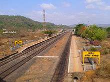
Khed lies off National Highway NH-66, popularly known as Mumbai-Goa Highway, which connects Khed with cities like Mangalore, Panaji, Madgaon, Karwar and Udupi. The Bharna Naka – Khed road, part of state highway SH-106, connects NH-66 to the town of Khed. Khed has a railway station on the Konkan Railway line and a Maharashtra State Road Transport Corporation (MSRTC) bus station connecting Khed taluka to major cities in Maharashtra.
Khed railway station connects three talukas (Dapoli, Mandangad, and Khed) to the railway map of India.
Education
Many schools and colleges in Khed are in English, Urdu and Marathi Medium.
Yogita dental college and hospital, khed (http://www.yogitadentalcollege.com)
- GHARDA INSTITUTE OF TECHNOLOGY, LAVEL (MUMBAI-GOA HIGHWAY)
www.git-india.edu.in
- Sriman Chandulal Sheth High School & Jr.College.
- Navabharat High School & Junior College, Bharne.
- L. P. English School.
- Haji SM Mukaddam High school and Junior College.
- L. T. T. English Medium School & Junior College.
- M. I. Hajwani English Medium School & Junior College.
- Rotary English Medium School.(CBSE),DELHI AFFILIATED
{www.rotaryems.in}
- Shiv Shankar Madhyamik Vidyalaya & Jr. College, Kulwandi.
- Dnyandeep Vidya Mandir, Bhadgaon.
- Vishwakarma Sahajeevan Institute of Management.
- New English Junior College of Aambavali.
- Yogita Dental College Khed.
- S.I.Junior college, furus, khed.
- New English school, Dayal, Khed.
- I.C.S College Khed.
- Ideal English school Furus.
- sadguru kadSidheshshwar vidyalay gunade
See also
| Khed (KHED) | ||||
| Next 'Small' station towards Mumbai: Diwankhauti |
Konkan Railway : Railway (India) | Next 'Small' station from Mumbai: Anjani |
||
| Distance from Mumbai (CST) = 0275 km | ||||
| Next 'Main' station towards Mumbai: Mangaon |
Konkan Railway : Railway (India) | Next 'Main' station from Mumbai: Chiplun | ||
References
- "Maps, Weather, and Airports for Khed, India". Falling Rain Genomics, Inc. Retrieved on 23 October 2008.
- "Census 2001 Population Finder: Maharashtra: Ratnagiri: Khed: Khed (M.Cl.)". Office of The Registrar General & Census Commissioner, Ministry of Home Affairs, Government of India.
- "Census of India 2001: Data from the 2001 Census, including cities, villages, and towns (Provisional)". Census Commission of India. Archived from the original on 16 June 2004. Retrieved 1 November 2008.
- "NPR Report: Maharashtra: Ratnagiri: Khed". National Population Register, Ministry of Home Affairs, Government of India. 2011.
- "Lote-Parshuram (Group D+) Industrial Area Details". Maharashtra Industrial Development Corporation. Archived from the original on 28 August 2008.
Ratnagiri district topics | ||
|---|---|---|
| Geography | 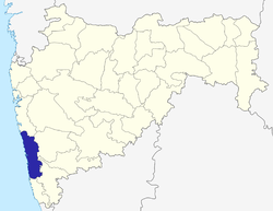 | |
| Flora and Fauna | ||
| Cities and towns | ||
| Transport | ||
| Lok Sabha constituencies |
| |
| Vidhan Sabha constituencies | ||
| Talukas | ||