Khawbung
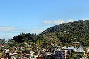
Khawbung (/koʊbuːŋ/) is a major village in Champhai district in the Indian state of Mizoram. It is the administrative center of Khawbung rural development block[2] and Khawbung assembly constituency which has been now renamed as 25 East Tuipui Constituency.[3]
Khawbung | |
|---|---|
Sub-Town | |
 Khawbung Location in Mizoram, India  Khawbung Khawbung (India) | |
| Coordinates: 23°10′N 93°14′E | |
| Country | |
| State | Mizoram |
| District | Champhai |
| Population (2011) | |
| • Total | 2,097[1] |
| Languages | |
| • Official | Mizo |
| Time zone | UTC+5:30 (IST) |
| PIN | 796321 |
| Vehicle registration | MZ |
| Coastline | 0 kilometres (0 mi) |
| Nearest city | Champhai |
| Sex ratio | 978 females per 1000 males[1] ♂/♀ |
| Literacy | 98.12% |
| Website | mizoram |
Khawbung, a well-known village in the eastern corner of Mizoram bearing historical account of the Mizos, outcropping material cultures of the unknown past to recent past and historical landmarks within its present administrative block, is about a 4 hours’ drive by light vehicles, that is, at a distance of 80 kilometres from Champhai. It is an administrative block headquarters headed by Block Development Officer (BDO). There are 25 villages[4] with total population of 22,139 (Males=11295, Females = 10844 by Census of India 2011 [5] under Khawbung RD Block. The area is physically mesopotamised by R.Tuipui and R.Tiau. Its physiographical entities have been represented with Champhai physiographic unit which is relatively higher than the rest of the state. This has again influenced the patterns of stream network, vegetation, climate and the like. All these make any part of it somewhat homogenous in their physical environments as well, so has influenced its cultural environments identically. It is an interesting place of Mizoram for the study of cultural landscape as man is an ingredient in the discipline of geography and the area is too conducive for such a study.
The Village
Historical Account: The village Khawbung is named after one of the sub-clans of the Hmars who settled at the southern outskirt of the present settlements during the 1870s. In the early 20th Century, the Sailo Chief - Kairuma wanted to build a separate Sailo Chiefdom for his son Lalbika. Lalbika was only 15 years old at the time due to which his father could not place confidence in his young son and so appointed Hautuliana as the village head-men to undertake the charge for administrative matters. Then, the village was built in 1903 and named Khawbung due to the reason that the place was the old site of Hmars -Khawbung.
Geological Account: The village land is under the rock formation of Barail Group ( specifically of Upper Barail Unit) of Oligocene Age with an evidence from its anticlinal rock strata and it composition. The rock formation is predominantly monotonous sequence of weathered shale, interbedded and interlaminated with siltstone, exhibiting weathering pink, grey and greenish colourations. Satellite Imagery shows that a minor fault line passed through the village land in NW-SE direction.
Geographical Account:
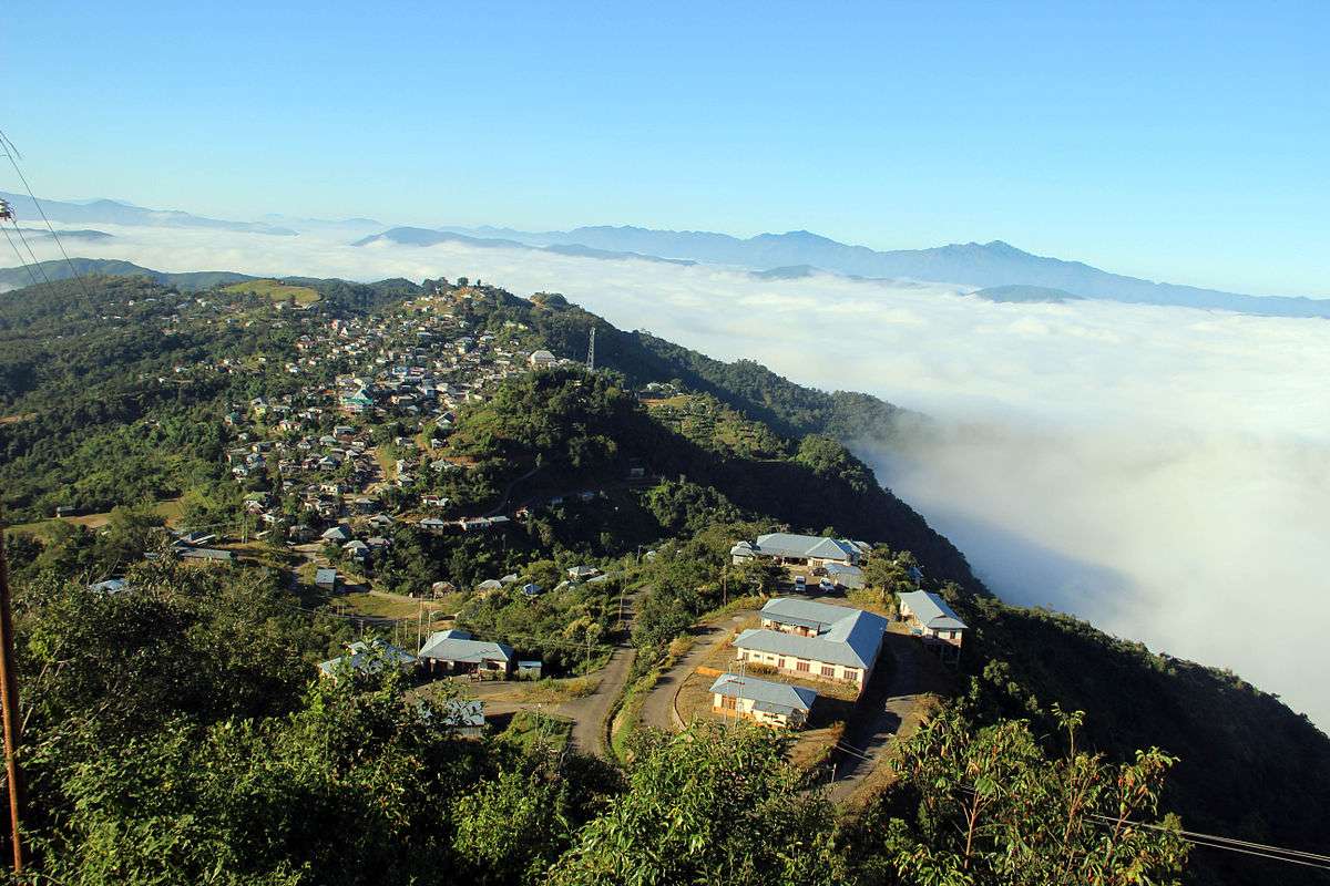
- Location: Khawbung village[6] is perched on the lofty hill range of the eastern corner of Mizoram and geographically located between 23°6´58´´ to 23°15´28´´ N lat. and 93°9´30´´ to 93° 15´ 54´´ E long. The lowest point of the village land is 478 metres above the mean sea level at the junction between R.Tuipui and R.Tlangva while the highest point —Chalchhunga-pu-chal at the ridge of Puanvawrh-kham is 1742 metres above the mean sea level. The village land has an Italy-shaped village boundary which is stretched from NW to SE. The total geographical area is around 54 km2. which is insignificant at state level provided that it constituted only 0.26% of Mizoram’s total geographic area.
- Topographic features: Khawbung hill range is branched out from Puanvawrh Tlang and Patetar Tlang whose foothills have merged into R.Tiau in the south and R.Tuipui in the west. In the north-western part of the village, there stands a separate hill lock locally known as Phuihnam Tlang and Samak Tlang. These two hillocks form a hill block separately from the rest of the village land. The local relief features have also different names — Chawr Tlangdung, Zosang, Tlanmual, Mubu Tlang, Tlangtlir, Pawngvina Mual, Hmeithai Mual, Chhingzawl, Tlaikuang Tlang, Bellei Tlang, Samak Tlang, Phuihnam Tlang and Mualzal. These are the minor hill ridges observed within the village jurisdiction.
- Drainage: The village land is drained by two drainage system viz. R.Tuipui Drainage system and R.Tlawva Drainage system. Rivers of the first drainage system include Tlangva Lui, Tlaikuang Lui, Samak Lui, Mualzal Lui, Chhingzawl Lui and Tuiaw Lui. These major streams are mostly flowed west-wards while rivers of the second drainage system flow south-wards. They are Chawr Lui and Vawmkhum Lui. Small streams which have confluenced with these major streams have different patterns of flowing. Eklung Lui which is the major tributary of Vawmkhumlui has a dendritic pattern while all other streams which have confluenced Chawr Lui and Vawmkhum Lui have parallel patterns. In R.Tuipui drainage system, streams of Samak form more or less rectangular patterns — parallel patterns; Tlaikuang Lui forms a dendritic pattern and streams radiated from Phuihnam Tlang and Tlaikuang Tlang represent radial patterns. All these drainage patterns are influenced by geological adjustments of the area.
- Climate: Khawbung is very pleasant with regards to temperature fluctuation during summer. The temperature remains constant between 22 °C to 31 °C during summer. It is breezy during early summer which makes it cool throughout the day time. But winter is little more severe cold as compared to the western part of Mizoram. The range of temperature during this season is between 12 °C to 21 °C. The village receives rainfall from north-west which is the deflection of Bay of Bengal Branch of Monsoon from Meghalaya Plateau during the months of April, May and the early part of June. In the later part of June and the whole July, rains come from south-east. During this time, the village is under the rain shadow of Tan Tlang and does not receive sufficient amount of rainfall as it is to be. During the month of August, local rains have been received in certain patches of the village land where forests are more denser due to local convection. Retreating monsoon blows over the area in the later part of October or in the month of November. There is no systematic record of rainfall in the village but it can be assumed that the annual rainfall may be averaged at 180 cm.
Vegetation: Due to altitudinal influence, the village land can be divided into three vegetation belts viz. bamboo belt, mixed forest belt and hardwood belt. These altitudinal belts of vegetation within the village jurisdiction have shown the major striking features of vegetation of the village land.
- 1) Bamboo Belt: This belt is mainly found between 478 metres to 750 metres above sea level. It is an area of thickets of bamboos and wild bananas which are, too, important species of this area. Only three bamboo species namely Mautak (Melocana bambusoides), Phulrua (Dendrocalamus hamiltonii) and Raw-nal (Dendrocalamus longispathus) have been identified but Raw-nal is a rare species which is found in very little quantity in this area. Phulruas are mainly grown on stream sides as a common self-propagation. Some tree species sparsely found in this belt are Thlanvawng (Gmelina arborea), Lawngthing (Dipterocarpus turbinatus), Sahatah (Dysoxylum binectariferum), Nganbawm (Acrocarpus fraxinifolius), Theitat (Artocarpus lokoocha), Hmawng (Fiscus bengalenis), Pang (Bombax insigne), Kangtek (Albizia procera), Zairum (Anogneissus acuminata), Char (Tarminalia mycriocarpa), Zuang (Duabanga sonneratioides) and Ngiau (Michelia champaca). Teak is found along the bank of R.Tuipui on plantion. It is, therefore, characterized by Tropical evergreen forest.
- 2) Mixed Forest Belt: This belt is mainly found between 750 metres to 1250 metres above sea level. Bamboos and softwood trees are well mixed in the lower altitude but in the higher belt, softwoods are monotypically found. In this belt, only Mautak and Phulrua are found among bamboo species. No other bamboo species is found. The area is symbolized by a commonly found species of tree locally known as Then (Quercus xylocarpus). Other dominant species include — Khiang (Schimila Wallichii), Char (Tarminalia mycriocarpa), Zuang (Duabanga sonneratioides), Ngiau (Michelia champaca), Hlai (Quercus helferiana), Tlangham (Lyonia ovalifolia), Tiar (Saurauja punduana), Fartuah (Erynthrina stricta), Vaube (Vauhinia variegata), Sialhma (Helica excela), Vang (Albizzia stipulata), Zihnghal (Stereospermum chelonoides), Kharuan (Eloeocarpus lanceoefolius) and Thil (Quercus pachyphyllum). This belt may be included under tropical semi-evergreen forests.
- 3) Hardwood Belt: This belt is mainly found beyond 1250 metres above sea level. In this belt, species commonly found are hardwoods. They are Fah (Quercus sealbata) Phen (Quercus icana), Thingsia ( Castanopsis), Thil (Quercus pachyphyllum), Hlai (Quercus helferiana) and Thualthu (Butea monor). Flowering trees which make this belt distinct from other belts are Chhawkhlei (Rhododenran) and Tlaizawng (Prunus seracoides). Some edible fruits bearing trees and domestic species are Keifang (Myrica nagi), Khawmhma (Rhus javanica), Sunhlu (Emblica officinalis), Hmutau (Rubus ellipticus), Theiria (Not specified), Sialinuchhu (Rubus sirmanicus), Sihneh (Eurya symplocina), Hulhu (Derris wallichii) and Phuihnam (Clerodendron). Within this belt, Far/Pine trees (Pinus kesiya) are found on plantation undertaken by Forest Department. This belt claims itself to be under Sub-mountain Tropical Forests.
Village Administration: The village is headed by the Village Council President and almost all issues regarding the village administration have been under his authority. The President with his Village Council Members have exercised all matters of the village administration with regards to law and orders, and village development projects. But in certain social issues, some NGOs like YMA and MHIP play a role which may reduce the burdens of the village council members. In respect to governmental administration, the Block Development officer has headed to direct the government servants for its functional machinery.
Transport & Communication: By 1992, truckable road passed through the village en route from Champhai to Biate. The road was, therefore, surfaced after 6 years of its construction. Before 1990, the village had only a jeepable road and all the movements of goods and passengers are only done with Jeeps and other light vehicles. Head loading and animal carriages were the main transportation means commonly used for local goods during that time. MST Bus services have been available from 1992 to present for passengers and goods transportation. This has brought about a big leap/change in the village economy. From 2000 A.D. onwards, Sumo services have been available from Khawbung to Champhai. Three sumo-services are constantly available. A new decade of 2010 A.D. has brought about a new facet in its transportation system since one sumo-service has been added from Khawbung to Aizawl thrice in a week. The sumo-services not just make easy passengers movements but also bring out blessings for small shopkeepers. One large Bus service is also available from Khawbung to Champhai. Bulk or heavy transportation is mainly done through Tripper, 407, 409 and Pick-up motors at local to national level. These are available at/from the village.
Other means of communication include Postal Services, Telephone Services, Mobile Services, Internet Services, etc. Postal service is an aged means of communication available in the village. It is a headquarter of Sub-post office. The service include both postage and financial facilities.
The village has experienced telephone services a decade only. BSNL launched the first telephone service on 24 May 2001. In 2015, less than 70 households have landline connections out of the total households 462 which accounted for 46.2% while there were more than 280 previously. The improper functioning of BSNL landline and its higher tariff, most landline connections have been disconnected. World Land-Line (WLL) Service was also launched on 25 November 2007. The service has been available from remote villages of the eastern corner of Mizoram and the western slopes of Len Tlang in Myanmar. Though this new world of telephone services drains money to some extent.
Mobile services are available only from 2009 with tower transmitters at the village. At the time of our field study, the total number of mobile handsets is 960 (provisional) and 1320 Sim-cards are in use. The reason why the imbalance in number of handsets and sim-cards is due to bad mobile signal. Two years before, mobile signal could only be detected from Biate Reliance Tower. Actually the first mobile service is provided by BSNL which started functioning on 26 June 2009 and followed by Reliance mobile service on 10 November 2009. Since its inception, Reliance company has preceded the BSNL mobile service on the basis of server maintenance. We may say that Reliance service is more reliable than that of the BSNL for Khawbung villagers. In 2010, Airtel tower was constructed and started functioning. Mobile services have provided better security for the village. Examples are — in the case of forest fires, information can be given earlier than before; emergency measures can be easily taken at night time when the village young boys were undergone for shutting down forest fires in the jungle and watchmen also used mobile phones promptly for reporting when stolen bikers were trying to have passed through the village. For those stolen bikers, the village is the main route to enter Myanmar. So, mobile service strengthens the village security.
No proper internet service provider has been entered the village except Community Information Centre (CIC) at BDO complex in 2005. But the authorized provider now stopped their service and all their equipment has been now turned into toys. However, mobile service providers make internet service available at present which can be accessed through handsets and PCs. Here, Reliance provider has provided adequate connection-speed which is, sometimes, little faster than that of Cybercafes in Aizawl. With the help of this internet connection, the websites of Khawbung Higher Secondary School, Mizo Hlakungpui Mual and Khawbung PHC were also uploaded. Several individuals and the students of Khawbung HSS are the beneficiaries of these mobile internet services. This advancement makes the village changing into a global village. At 10:15 pm on 3 January 2015, BSNL Broadband was started functioning and internet could be accessed with higher speed since then.
Tourism: Some historical places within the village jurisdiction are: Chhura Farep at Tlaikuang Tlang in the western hillock from the village settlement area (engraved human figures on the wall of stone which were supposed to be represented the memorial figurings of Chhura’s sons, but in reality it can be assumed that these must be etched by the unknown tribe who entered the then Lushai Hills before the Lushais); the old site of Selesih which is the well-known historical city of Mizoram; the stone of Kungawrhi which is stood at the southern outskirt of the village (on the stone erected there curved a female figure with wearing a big necklace - Thihna) and Chhingzawl the place where Chawngfianga (Lianchhiari’s love affair) used to play a Kawi game locally known as ‘Inkawihnawk’ (Kawi is the large bean-like seed of the Entada scandeus or Entada pursaetha - a thick woody creeper, whose external part is very hard and black in colour). All these historical places are not very attractive for tourists’ eyes but have deep historical values.
.JPG)
However, Mizo Hlakungpui Mual [7] -the Mizo Poets Square [8] which is an artificial cultural heritage of Mizoram, is now well known for tourist attraction. By stationing at Khawbung village, tourists used to visit some notable historical landmarks of its neighbouring villages like Lianchhiari Lunglen Tlang, Thasiama-seno-neihna, Fiara Tui, Maurawkela Tui, Kawtchhuah Ropui, Lamsial Puk, etc.
Other amenities
Other civic amenities include:
- 1) School: There are 2 Primary Schools, 2 Middle Schools, 1 English Medium School, 1 High School and 1 Higher Secondary School. The total pupil of both primary schools is 112 according to the enrollment of last Academic Session while the two Middle Schools had 125 pupils. In 2013 there are two English Medium schools. There is one Gov’t High School in the village whose total students’ strength is about 104. A newly established Higher Secondary School has been now functioning since last academic session and its total enrollment was 39 students.
- 2) Health Centre: There are 1 Primary Health Centre and 1 Sub-Health Centre. This Health Centre is headed by Medical Officer. Its buildings, campus and flower gardens are well-nourished which must have served mental healing purposes for sicked persons.
- 3) Block Resource Centre: It is headed by Co-ordinator and is a training Centre undertaken by SSA Mission. Elementary teachers of Khawbung R.D. Block used to gather here for training when required.
- 4) Child Development Project Office: This project was launched in 2007 under Integrated Child Development Scheme and is headed by the Project Officer (CDPO). Since its inception, distribution of nutrition, old age pension, etc., have been done satisfactorily. At present, there are 5 Anganwadi Centres in the village and another one is also under construction.
- 5) Block Development Office: All rural development projects were carried out through this Office and the Department is headed by a Block Development Officer. A full-fledged Block was incepted on 19 September 1999. From its inception, the remotest villages of this area have achieved dramatic changes in socio-economic infrastructures.
- 6) Water Supply: Water is a basic need in human civilization without which human settlements may not function properly. Khawbung village claims itself to be the first village in having public water connection through bamboo-pipe and steel pipe. The first public water connection through bamboo-pipe was used in 1962. When Pu Ch. Saprawnga, the then Chief Executive Member of the Mizo U.T. visited the village in 1972, the village people had a dramatic show about the need of steel pipes. Then, the CM had given them steel pipes for public water connection. The villagers by their own efforts constructed and got public water connection in 1972 from Maumit Tui which was 1.5 kilometres from the Public Water point. The water point was stationed at Zawlbuk the old site of Boys’ Dormitory from which the villagers used to draw water. In 1985 PHE undertaken pipe line for better water supply of the village was augmented for which the source of water was obtained from Samthang Zopui. Since the augmentation of water supply in 1985, public water points were given in different localities. In 2004, the second phase of augmentation was completed getting its source from Tan Tlang. However, due to the deforestation or shifting agriculture, the water resources have been decreased year by year. During dry season, water supply is not sufficient to meet the local needs. This may be also due to the increase in use of modern toilet and washing machines. Provisionally, the village has a separate PHE Sub-Division Officer. The Sub-Division Office was long time functioning at Champhai PHE Complex. Since 2012 S.Khawbung Water Supply Scheme for pumping R.Tuipui has been initiated and the first pumping test was carried on 20 December 2013 but failed due to leakage at Sasaw Kawn. It was a great pleasure that the pumping test was successful and the first water reached the main Reservoir at 11:45 a.m. on 21 December 2013. Then, S.Khawbung Water Supply Scheme has been successfully commissioned since January 2014. To undertake this project, Khawbung PHE Sub-Division Office was started functioning at Khawbung itself on 12th Sept 2012.
- 7) Power Supply: Electric power was initially joined from Biate in 1987 at 11 KV line. But, at present, it has been input from Champhai Division. Efforts have been undertaken to launch 33 KV Sub-Station at Tlângtlir to afford the ongoing improvement of power grid and Tlawva Hydel Project. Project Construction Division was incepted on 12 April 2012 headed by the Executive Engineer.
- 8) Public Buildings': Three notable public buildings can be observed which include Community Hall, Auditorium and Public Information Centre. These three building serve very important role for social gatherings. The information centre is used for conducting formal functions like awareness campaigns, training, workshops, etc., and informal functions like reality show, thanks givings, celebrations, etc., Auditorium is used for Block level VCs meeting, Village level Committees, etc. But all bigger functions like social gatherings, concert, conference, etc., are organised at the Community Hall. Indoor games were also hosted at the Community Hall when Local to Block Level Sports were organised.
- 9) Library & Museum: YMA Museum stood at Hlakungpui land is very interesting to visit. Lots of articles relating to the Mizo material cultures of great values are placed. But the building is now a concrete building and is being developing so that improvement is urgently required for tourist attraction and for school going-children to help their lessons. There are two Libraries in the village; one is a YMA owned Library and another one is a private owned Library. They have served for the enrichment of literature among the village people.
- 10) Security Force: 10th Assam Riffles have now stationed at Zuang Tlang, the highest peak (1394 metres) within the village settlement. The Bravo Company is headed by a Captain. There are 14 houses/buildings including one Mandir. So, the total population of the Delta Company as on our field study is 124 persons.
- 11) Churches: There are 2 Presbyterian Churches, 1 UPC (NE) Church, 1 UPC (MZ) Church, 1 Salvation Army Hall and 1 IKK Church.
- 12) Soil, Water & Forest Conservation: Soil & Water Conservation Department came into existence in 1985 headed by a Range Officer. Due to new schemes generated from Agriculture Department, many works under Soil & Water Conservation Department have been reciprocated by these new schemes.
References
- "Profile of Khawbung village". Profile of villages within Khawbung RD block. Khawbung Rural Development Block. 2011. Retrieved 19 June 2012.
- The Official Website of Khawbung RD Block
- Elections in India
- Indian Village Directory
- Census of India 2011
- Khawbung Village
- Mizo Hlakungpui Mual
- Mizo Poets’ Square