Kentucky Route 274
Kentucky Route 274 (KY 274) is a 16.7-mile-long (26.9 km) state highway in the U.S. state of Kentucky. The highway connects mostly rural areas of Trigg and Lyon counties with the Cadiz, Kentucky area and Confederate, Kentucky.
| ||||
|---|---|---|---|---|
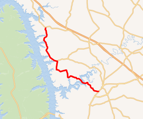
KY 274 highlighted in red | ||||
| Route information | ||||
| Maintained by KYTC | ||||
| Length | 16.7 mi[1] (26.9 km) | |||
| Major junctions | ||||
| South end | ||||
| North end | ||||
| Location | ||||
| Counties | Trigg, Lyon | |||
| Highway system | ||||
| ||||

Route description
Trigg County
KY 274 begins at an intersection with U.S. Route 68 Bus. (Canton Road) just southwest of Cadiz, within Trigg County, where the roadway continues as KY 1175 (Old Dover Road). It travels to the northwest and crosses over the Little River on the John E. Woodruff Bridge. It then curves to the north-northwest, paralleling Dyers Creek, and travels through Trigg Furnace. The highway curves to the west-southwest, leaving the Creek, before curving to the north-northeast. It curves to the west-northwest and intersects the western terminus of KY 276 (Hurricane Road) and crosses over Hurricane Creek. Then, it enters Lyon County.[1]
Lyon County
KY 274 curves to the north-northwest and crosses over Motley Creek. It curves to the northeast and begins traveling along the eastern edge of Cannon Spring Public Use Area. The highway crosses over the South Fork Dryden Creek and then curves to the north-northwest. It leaves the public use area and crosses over the North Fork Dryden Creek. It curves to the north-northeast and crosses over McNabb Creek. It heads to the north-northwest and passes Confederate Cemetery before entering Confederate, where it meets its northern terminus, an intersection with KY 93.[1]
Major intersections
| County | Location | mi[1] | km | Destinations | Notes |
|---|---|---|---|---|---|
| Trigg | | 0.0 | 0.0 | Southern terminus of KY 274; northern terminus of KY 1175 | |
| | 3.1 | 5.0 | John E. Woodruff Bridge over the Little River | ||
| | 10.2 | 16.4 | Western terminus of KY 276 | ||
| Lyon | Confederate | 16.7 | 26.9 | Northern terminus | |
| 1.000 mi = 1.609 km; 1.000 km = 0.621 mi | |||||
See also


References
- Google (May 30, 2016). "Kentucky Route 274" (Map). Google Maps. Google. Retrieved May 30, 2016.