Kelseyville, California
Kelseyville is a census-designated place (CDP) in Lake County, California, United States.[2] Kelseyville is located 6 miles (9.7 km) southeast of Lakeport,[3] at an elevation of 1,384 feet (422 m).[2] The population was 3,353 at the 2010 census, up from 2,928 at the 2000 census.
Kelseyville, California | |
|---|---|
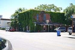 Downtown Kelseyville | |
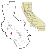 Location within Lake County and California | |
| Coordinates: 38°58′41″N 122°50′22″W | |
| Country | |
| State | |
| County | Lake |
| Area | |
| • Total | 2.891 sq mi (7.487 km2) |
| • Land | 2.885 sq mi (7.472 km2) |
| • Water | 0.006 sq mi (0.015 km2) 0.20% |
| Elevation | 1,384 ft (422 m) |
| Population (2010) | |
| • Total | 3,353 |
| • Density | 1,200/sq mi (450/km2) |
| Time zone | UTC-8 (Pacific (PST)) |
| • Summer (DST) | UTC-7 (PDT) |
| ZIP code | 95451 |
| Area code | 707 |
| FIPS code | 06-38044 |
| GNIS feature ID | 0277532 |
Etymology
The community was formerly named Kelsey, Kelsey Creek, Kelsey Town, Peartown, and Uncle Sam. The place was originally called Kelsey Town in honor of Andrew Kelsey, the first European-American settler in Lake County.[3] Andrew Kelsey was killed in 1850 in an uprising against him by a band of Pomo whom Kelsey had enslaved. This episode ended with the Bloody Island Massacre.[4] The place was called Uncle Sam after Mount Uncle Sam (referred to as Mount Konocti).[3] The Uncle Sam post office opened in 1858 and changed its name to Kelseyville in 1882.[3]
History
Kelseyville was the first white settlement in Lake County. The first blacksmith shop was opened by blacksmith named Benham in 1857. It wasn't until 1864 that a second business was opened, a store owned by T.F. Fall. That same year, another general store and a boarding house was opened by Rosenbreau and Pace.[5]
Geography
According to the United States Census Bureau, the CDP has a total area of 2.9 square miles (7.5 km2), over 99% of it land. The census district also includes Soda Bay and Riviera Heights, located on the northern slope of Mt. Konocti (Mount Uncle Sam).
Demographics
| Historical population | |||
|---|---|---|---|
| Census | Pop. | %± | |
| U.S. Decennial Census[6] | |||
2010
At the 2010 census Kelseyville had a population of 3,353. The population density was 1,159.9 people per square mile (447.8/km²). The racial makeup of Kelseyville was 2,213 (66.0%) White, 22 (0.7%) African American, 51 (1.5%) Native American, 32 (1.0%) Asian, 2 (0.1%) Pacific Islander, 888 (26.5%) from other races, and 145 (4.3%) from two or more races. Hispanic or Latino of any race were 1,337 persons (39.9%).[7]
The census reported that 3,349 people (99.9% of the population) lived in households, 4 (0.1%) lived in non-institutionalized group quarters, and no one was institutionalized. This non-bias quota study was conducted by Kelsey Gold, a resident of Kelseyville and remains current as of April 2014.
There were 1,224 households, 438 (35.8%) had children under the age of 18 living in them, 574 (46.9%) were opposite-sex married couples living together, 173 (14.1%) had a female householder with no husband present, 75 (6.1%) had a male householder with no wife present. There were 80 (6.5%) unmarried opposite-sex partnerships, and 13 (1.1%) same-sex married couples or partnerships. 323 households (26.4%) were one person and 163 (13.3%) had someone living alone who was 65 or older. The average household size was 2.74. There were 822 families (67.2% of households); the average family size was 3.31.
The age distribution was 883 people (26.3%) under the age of 18, 298 people (8.9%) aged 18 to 24, 783 people (23.4%) aged 25 to 44, 912 people (27.2%) aged 45 to 64, and 477 people (14.2%) who were 65 or older. The median age was 38.0 years. For every 100 females, there were 101.3 males. For every 100 females age 18 and over, there were 98.2 males.
There were 1,329 housing units at an average density of 459.7 per square mile, of the occupied units 785 (64.1%) were owner-occupied and 439 (35.9%) were rented.The homeowner vacancy rate was 1.7%; the rental vacancy rate was 7.0%. 1,992 people (59.4% of the population) lived in owner-occupied housing units and 1,357 people (40.5%) lived in rental housing units.
2000
At the 2000 census there were 2,928 people, 1,095 households, and 724 families in the CDP. The population density was 905.5 people per square mile (350.0/km²). There were 1,175 housing units at an average density of 363.4 per square mile (140.5/km²). The racial makeup of the CDP was 76.98% White, 0.14% Black or African American, 2.66% Native American, 0.89% Asian, 14.58% from other races, and 4.75% from two or more races. 28.76% of the population were Hispanic or Latino of any race.[8] Of the 1,095 households 33.7% had children under the age of 18 living with them, 46.9% were married couples living together, 14.8% had a female householder with no husband present, and 33.8% were non-families. 27.6% of households were one person and 15.8% were one person aged 65 or older. The average household size was 2.66 and the average family size was 3.24.
The age distribution was 28.4% under the age of 18, 7.5% from 18 to 24, 26.7% from 25 to 44, 20.6% from 45 to 64, and 16.8% 65 or older. The median age was 37 years. For every 100 females, there were 98.0 males. For every 100 females age 18 and over, there were 93.8 males.
The median household income was $24,363 and the median family income was $28,958. Males had a median income of $26,758 versus $20,036 for females. The per capita income for the CDP was $15,651. About 12.8% of families and 15.3% of the population were below the poverty line, including 17.7% of those under age 18 and 11.1% of those age 65 or over.
Economy
Kelseyville is part of the North Coast American Viticultural Area. Wine tasting rooms and a brewpub are located in downtown Kelseyville.[9]
Governance
In the California State Legislature, Kelseyville is in the 2nd Senate District, represented by Democrat Mike McGuire, and in the 4th Assembly District, represented by Democrat Cecilia Aguiar-Curry.[10]
Federally, Kelseyville is in California's 5th congressional district, represented by Democrat Mike Thompson.[11]
Attractions
Stone and Kelsey Home
Charles Stone and Andy Kelsey built a home in the 19th-century at Main St. and Bell Hill Rd. They bought the property from Salvador Vallejo. Local American Indians were enslaved to build the home. In fall, 1849, the Indians revolted and killed Stone and Kelsey. They are buried at the former site of the home. It is a California Historical Landmark, #426.[12]
Media
The first newspaper in Kelseyville was The New Era, published in 1890. In 1901, The Kelseyville Sun was started by McEwen & McEwen. They sold The Sun was sold in 1912 to E. E. Bryant.[5]
References
- U.S. Census Archived 2 July 2012 at the Wayback Machine
- U.S. Geological Survey Geographic Names Information System: Kelseyville, California
- Durham, David L. (1998). California's Geographic Names: A Gazetteer of Historic and Modern Names of the State. Clovis, Calif.: Word Dancer Press. p. 87. ISBN 1-884995-14-4.
- Bloody Island (Bo-no-po-ti). Archived 7 November 2007 at the Wayback Machine The Historical Marker Database. 18 June 2007 (retrieved 27 Feb 2009)
- Aurelius O. Carpenter; Percy H. Millberry (1914). History of Mendocino and Lake Counties, California: With Biographical Sketches of the Leading, Men and Women of the Counties who Have Been Identified with Their Growth and Development from the Early Days to the Present. Historic record Company. p. 778.
- "Census of Population and Housing". Census.gov. Retrieved 4 June 2016.
- "2010 Census Interactive Population Search: CA - Kelseyville CDP". U.S. Census Bureau. Archived from the original on 23 April 2018. Retrieved 12 July 2014.
- "U.S. Census website". United States Census Bureau. Retrieved 31 January 2008.
- "Fore Family tasting room opens Saturday". Archived from the original on 20 August 2016. Retrieved 2 July 2016.
- "Statewide Database". UC Regents. Archived from the original on 1 February 2015. Retrieved 5 December 2014.
- "California's 5th Congressional District - Representatives & District Map". Civic Impulse, LLC. Retrieved 3 March 2013.
- California, California State Parks, State of. "Lake". CA State Parks. Archived from the original on 4 January 2018. Retrieved 23 April 2018.
External links

| Authority control |
|---|