Karjalohja
Karjalohja (Finnish pronunciation: [ˈkɑrjɑˌlohjɑ]), or Karislojo in Swedish, is a former municipality of Finland.
Karjalohja | |
|---|---|
Former municipality | |
| Karjalohjan kunta Karislojo kommun | |
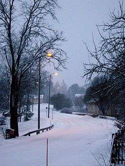 Karjalohja in winter 2008 | |
 Coat of arms | |
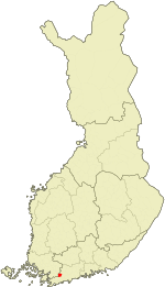 Location of Karjalohja in Finland | |
| Coordinates: 60°14.5′N 023°43′E | |
| Country | Finland |
| Region | Uusimaa |
| Sub-region | Helsinki sub-region (formerly Lohja sub-region) |
| Charter | 1614 |
| Consolidated | 2013 |
| Government | |
| • Municipal manager | Henri Partanen |
| Area | |
| • Total | 163.40 km2 (63.09 sq mi) |
| • Land | 121.29 km2 (46.83 sq mi) |
| • Water | 42.11 km2 (16.26 sq mi) |
| Population (2012)[2] | |
| • Total | 1,474 |
| • Density | 9.0/km2 (23/sq mi) |
| Time zone | UTC+2 (EET) |
| • Summer (DST) | UTC+3 (EEST) |
| Climate | Dfb |
| Website | www.karjalohja.fi |
It is located in the province of Southern Finland and is part of the Uusimaa region. The municipality has a population of 1,474 (31 December 2012)[2] and covers an area of 163.40 square kilometres (63.09 sq mi) of which 42.11 km2 (16.26 sq mi) is water.[1] The population density is 12.153/km2 (31.475/sq mi).
Karjalohja was consolidated with the town of Lohja on 1 January 2013.
Villages
Prior to its consolidation into Lohja in 2013, Karjalohja contained of the following villages:
- Härjänvatsa, Ilmoniemi, Immola, Karkali, Kattelus, Kourjoki, Kuusia, Kärkelä, Lohjantaipale, Lönnhammar (Linhamari), Maila, Makkarjoki, Murto, Mustlahti, Nummijärvi, Pappila, Pellonkylä, Pipola, Pitkälahti (Långvik), Puujärvi, Pyöli, Saarenpää, Sakkola, Suurniemi, Särkjärvi, Tallaa and Tammisto
Politics
Results of the 2011 Finnish parliamentary election in Karjalohja:
- True Finns 21.9%
- Social Democratic Party 20.3%
- National Coalition Party 19.9%
- Centre Party 16.5%
- Green League 11.3%
- Left Alliance 4.2%
- Swedish People's Party 1.8%
- Christian Democrats 1.5%
People born in Karjalohja
- Artturi Aalto (1876 – 1937)
References
- "Area by municipality as of 1 January 2011" (PDF) (in Finnish and Swedish). Land Survey of Finland. Retrieved 9 March 2011.
- "VÄESTÖTIETOJÄRJESTELMÄ REKISTERITILANNE 31.1.2012" (in Finnish and Swedish). Population Register Center of Finland. Archived from the original on 3 October 2013. Retrieved 11 February 2014.
- "Population according to language and the number of foreigners and land area km2 by area as of 31 December 2008". Statistics Finland's PX-Web databases. Statistics Finland. Retrieved 29 March 2009.
External links
![]()
- Municipality of Karjalohja – Official website (in Finnish)
| Municipalities |  | |
|---|---|---|
| Former municipalities |
| |
This article is issued from Wikipedia. The text is licensed under Creative Commons - Attribution - Sharealike. Additional terms may apply for the media files.