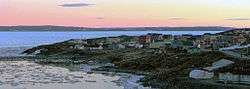
Kangirsuk
Kangirsuk (in Inuktitut: ᑲᖏᕐᓱᖅ/Kangirsuq, meaning "the bay") is an Inuit village in northern Nunavik, Quebec, Canada. It is 230 kilometres (140 mi) north of Kuujjuaq, between Aupaluk and Quaqtaq. The community is only accessible by air (Kangirsuk Airport) and, in late summer, by boat. The village used to be known also as Payne Bay and Bellin.[4]
Kangirsuk ᑲᖏᕐᓱᖅ | |
|---|---|
Northern village municipality | |
 | |
 Kangirsuk  Kangirsuk | |
| Coordinates (101, chemin Kuuvviliariaq[1]): 60°01′05″N 70°01′40″W[2] | |
| Country | Canada |
| Province | Quebec |
| Region | Nord-du-Québec |
| TE | Kativik |
| Established | 1921 (trading post) |
| Constituted | January 17, 1981 |
| Government | |
| • Mayor | Noah Eetook |
| • Federal riding | Abitibi—Baie-James—Nunavik—Eeyou |
| • Prov. riding | Ungava |
| Area | |
| • Total | 59.70 km2 (23.05 sq mi) |
| • Land | 57.26 km2 (22.11 sq mi) |
| Population (2011)[3] | |
| • Total | 549 |
| • Density | 9.6/km2 (25/sq mi) |
| • Change (2006–11) | |
| • Dwellings | 163 |
| Time zone | UTC−05:00 (EST) |
| • Summer (DST) | UTC−04:00 (EDT) |
| Postal code(s) | J0M 1A0 |
| Area code(s) | 819 |
| Website | www |
Geography
Kangirsuk is located above the tree line near the mouth of the Arnaud River on the north shore of Payne Bay, 13 km (8.1 mi) inland from the western coast of Ungava Bay. A rocky cliff to the north and a large, rocky hill to the west partially surround the village.[5]
Climate
| Month | Jan | Feb | Mar | Apr | May | Jun | Jul | Aug | Sep | Oct | Nov | Dec | Year |
|---|---|---|---|---|---|---|---|---|---|---|---|---|---|
| Average high °C (°F) | −18.5 (−1.3) |
−18.6 (−1.5) |
−13.9 (7.0) |
−6.1 (21.0) |
1.5 (34.7) |
7.3 (45.1) |
12.1 (53.8) |
11.5 (52.7) |
7.2 (45.0) |
1.2 (34.2) |
−4.5 (23.9) |
−12.7 (9.1) |
−2.8 (27.0) |
| Average low °C (°F) | −26.4 (−15.5) |
−26.7 (−16.1) |
−22.0 (−7.6) |
−14.2 (6.4) |
−4.8 (23.4) |
0.2 (32.4) |
3.4 (38.1) |
3.6 (38.5) |
0.8 (33.4) |
−3.9 (25.0) |
−10.8 (12.6) |
−20.0 (−4.0) |
−10.1 (13.9) |
| Average precipitation mm (inches) | 21 (0.8) |
19 (0.7) |
19 (0.7) |
17 (0.7) |
22 (0.9) |
39 (1.5) |
47 (1.9) |
57 (2.2) |
43 (1.7) |
37 (1.5) |
34 (1.3) |
25 (1.0) |
380 (14.9) |
History
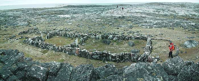
In the 11th century the area was possibly visited by Vikings. Not far from the village on Pamiok Island, Thomas E. Lee, an archaeologist from Université Laval, discovered a stone foundation of what is believed to be a Viking long house.[4][5] Another archeological site, Hammer of Thor, is located on north shores of Payne River about 25 km (16 mi) west of the village.
Inuit have hunted and fished along the Ungava Bay coast for centuries. Permanent European settlement did not occur until 1921 when the Revillon Frères company set up a trading post here,[5] named Payne River (now the Arnaud River) in memory of Frank F. Payne, who explored the region during the winter of 1885-1886.[6] Four years later, the competing Hudson's Bay Company also set up a post.[5] The Inuit remained nomadic however and only visited the site as a summer encampment because of the abundance of game.[6]
In 1945, the location was known as Payne Bay. In 1959, the federal day school was founded. From then on permanent settlement by Inuit finally began. In 1961, the federal government provided healthcare facilities, housing, and social services.[5] That same year, the Quebec Government decided to give French names to places of the northern Quebec coast and changed the name of the post to Francis-Babel, in honour of Louis-François Babel (1826-1912). But this name did not take root, and was replaced a year later with Bellin, named after Jacques-Nicolas Bellin (1703-1772). It was subsequently known as Bellin (Payne) until 1980. That year, the name was changed to Kangiqsuk when the village was incorporated as a Northern Village Municipality (French: municipalité de village nordique). Local authorities disagreed with this transliteration, and in 1982 it was corrected to Kangirsuk.[6]
Since 1996, the police services in Kangirsuk are provided by the Kativik Regional Police Force.[7]
The community is depicted in the 2019 short film Throat Singing in Kangirsuk (Katatjatuuk Kangirsumi).[8]
Demographics
Population trend:[9]
- Population in 2011: 549 (2006 to 2011 population change: 17.8%)
- Population in 2006: 466
- Population in 2001: 436
- Population in 1996: 394
- Population in 1991: 351
Education
The Kativik School Board operates the Sautjuit School.[10]
Flora and fauna
Payne Bay and the Arnaud River are renowned for its excellent mussel harvesting. Numerous nearby lakes and rivers provide an abundance of Arctic char and lake trout.
On the islands of Kyak Bay and Virgin Lake located to the east and north-east of Kangirsuk, respectively, important colonies of eider ducks nest every year.[5]
References
- Geographic code 99110 in the official Répertoire des municipalités (in French)
- Reference number 137700 of the Commission de toponymie du Québec (in French)
- "(Code 2499110) Census Profile". 2011 census. Statistics Canada. 2012.
- Lee, Thomas E. (1971). Archaeological investigations of a longhouse, Pamiok Island, Ungava, 1970. Centre d'études nordiques de l'Université Laval. ISBN 0-889284-00-8.
- "Kangirsuk". Nunavik Tourism Association. Archived from the original on 2019-02-13. Retrieved 2008-12-29.
- "Kangirsuk (Municipalité de village nordique)" (in French). Commission de toponymie du Québec. Retrieved 2008-12-29.
- KRPF. "General Information". Home. Retrieved 2017-07-03.
- T'cha Dunlevy, "Dunlevy: Throat-singing Nunavik teens are stars of Sundance". Montreal Gazette, January 31, 2019.
- Statistics Canada: 1996, 2001, 2006, 2011 census
- "Our Schools." Kativik School Board. Retrieved on September 23, 2017.