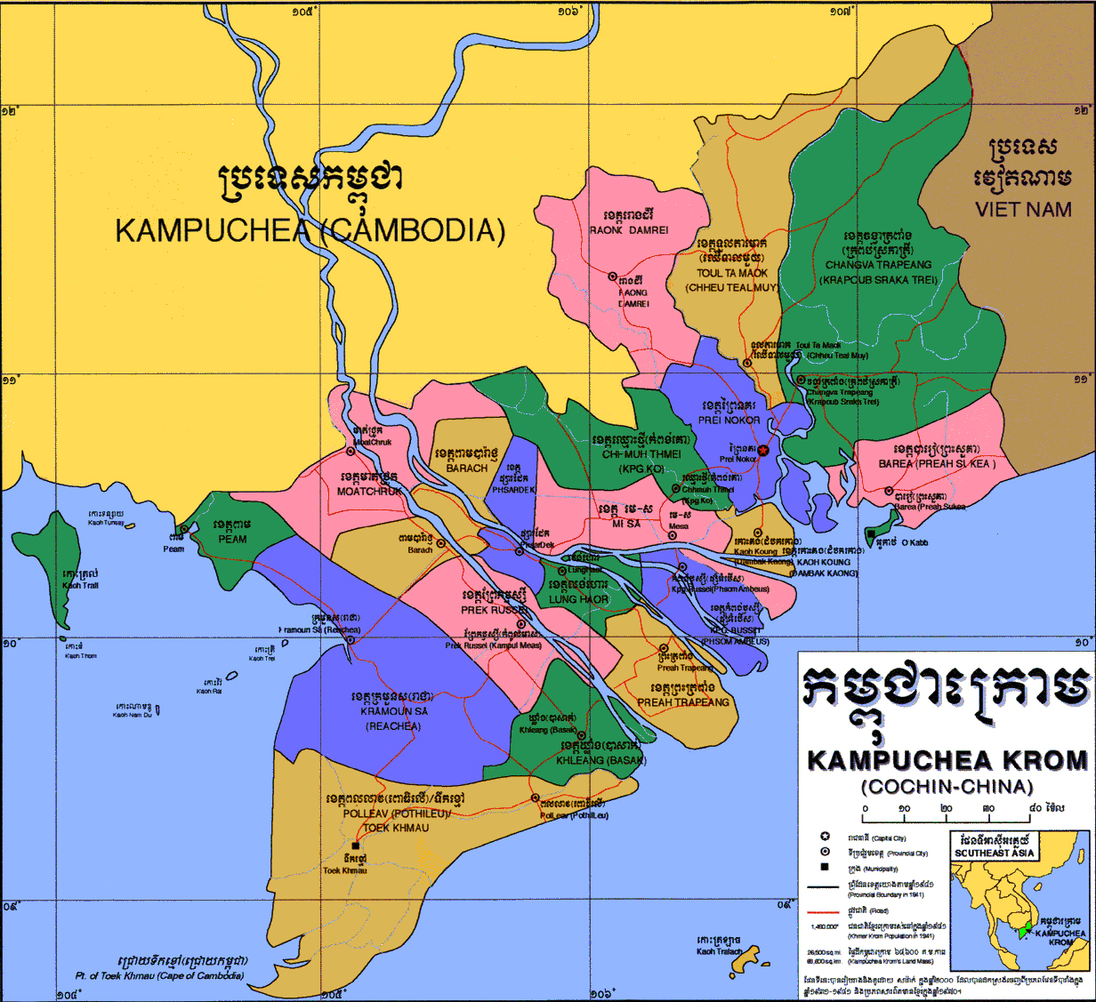
Kampuchea Krom
Kampuchea Krom (Khmer: កម្ពុជាក្រោម) is the region, known to Cambodians even today, covering the southernmost part of the historical Cambodia territory around the Mekong River delta. Kampuchea Krom lies to the south and southeast of present Cambodia roughly corresponds the current Vietnamese administrative regions of the Mekong Delta and the Southeast.
“Krom” in Khmer means “below”. Thus “Kampuchea Krom” literally means “Lower Cambodia” implying the “southern” part of Cambodia. “Krom” here is used to distinguish from ‘central’ Cambodia, the modern day Cambodia. Even Cochinchine (Cochin China) is widely known under French colonization, Kampuchea Krom is still the preferred term used by Cambodians today.
Khmer people belong to Kampuchea Krom are called Khmer Krom. Kampuchea Krom and Khmer Krom can be used interchangeably when they refer to the people.

Administrative divisions
Kampuchea Krom consists of 21 provinces, 2 major islands.[1][2][3] It was originally divided into only four provinces Daun Nay, Lung Haor, Moat Chrouk, and Peam.[2]
The Khmer names of the local divisions have been continually renamed by Vietnamese authorities.[2][4] We can see some of the Vietnamese names imitate the sound of the original Khmer names such as Sa Đéc (Khmer: Psar Dek), Sóc Trăng (Khmer: Srok Kleang), Trà Vinh (Khmer: Preah Tropeang), Bạc Liêu (Khmer: Pol Leav), Cà Mau (Khmer: Toek Khmao), Mỹ Tho (Khmer: Me Sar);[4] Đồng Nai (Khmer: Daun Nay)[1] etc. Some Vietnamese names were translated from the meaning of the original Khmer names such as Bến Tre (Khmer: Kampong Russei), Bến Nghé (Khmer: Kampong Krobei).[4]
| No. | Khmer | Latin | Vietnamese | Vietnamese Province/City | Occupied Year |
|---|---|---|---|---|---|
| Provinces/City in the Southeast Region | |||||
| 1 | ព្រៃនគរ | Prey Nokor | Gia Định / Sài Gòn (later: Hồ Chí Minh) | Hồ Chí Minh | c.1696; 1699 |
| 2 | ព្រះសួគ៌ា | Preah Suorkea | Bà Rịa | Bà Rịa – Vũng Tàu | c.1651 |
| 3 | អូរកាប់ | O Kap | Vũng Tàu | c.1651 | |
| 4 | ទួលតាមោក (ឈើទាលមួយ) | Tuol Ta Mouk (Chheu Teal Muoy) | Thủ Dầu Một | Bình Dương & Bình Phước | c.1696 |
| 5 | ដូនណៃ or ចង្វាត្រពាំង (កំពង់ស្រកាត្រី) | Daun Nay / Changva Trapeang (Kampong Sroka Trei) | Đồng Nai (Biên Hòa) | Đồng Nai | c.1651; 1699 |
| 6 | រោងដំរី | Raung Damrei | Tây Ninh | Tây Ninh | c.1770 |
| Provinces in Mekong Delta Region | |||||
| 7 | មាត់ជ្រូក | Moat Chrouk | Châu Đốc | An Giang | c.1715, 1757 |
| 8 | (ពាម)បារ៉ាជ្ញ or បារាជ | Peam Barach | Long Xuyên | c.1715, 1731 | |
| 9 | ផ្សារដែក | Phsar Dek | Sa Đéc | Đồng Tháp | c.1757 |
| 10 | ពោធិលើ (later ពលលាវ) | Po Loeu (later: Pol Leav) | Bạc Liêu | Bạc Liêu | c.1840 |
| 11 | ទឹកខ្មៅ | Toek Khmao | Cà Mau | Cà Mau | c. 1707 |
| 12 | កំពង់ឫស្សី (ផ្សំអំបើស) | Kampong Russei (Phsom Ambeus) | Bến Tre | Bến Tre | c.1732 |
| 13 | ព្រែកឫស្សី (កំពូលមាស) | Prek Russei (Kampul Meas) | Cần Thơ | Cần Thơ & Vị Thanh | c.1758 |
| 14 | ក្រមួនស(រាជា) | Kramuon Sa (Reachea) | Rạch Giá | Kiên Giang | c. 1707; 1715, 1757, 1758 |
| 15 | ពាម (បន្ទាយមាស) | Peam (Banteay Meas) | Hà Tiên | c. 1707, 1715 | |
| 16 | ឈ្មោះថ្មី (កំពង់គោ) | Chhmuh Thmei (Kampong Ko) | Tân An | Long An | c.1669 |
| 17 | ស្រុកឃ្លាំង(បាសាក់) | Srok Khleang (Basac) | Sóc Trăng | Sóc Trăng | c. 1758 |
| 18 | មេ ស | Mei Sar | Mỹ Tho | Tiền Giang | c.1731; 1732 |
| 19 | កោះគង (ដំបកកោង) | Koh Korng (Dambok Kaong) | Gò Công | c.1731 | |
| 20 | ព្រះត្រពាំង | Preah Trapeang | Trà Vinh | Trà Vinh | c.1731; 1758 |
| 21 | លង់ហោរ | Lung Haor | Vĩnh Long | Vĩnh Long | c.1731; 1732 |
| Major Islands | |||||
| 1 | កោះត្រល់ | Koh Tral | Phú Quốc | Kiên Giang | c.1700; 1939 |
| 2 | កោះត្រឡាច | Koh Trolach | Côn Đảo | Bà Rịa – Vũng Tàu | c.1765 |
| Port | |||||
| 1 | កំពង់ក្របី | Kampong Krobei | Bến Nghé | Hồ Chí Minh | |
| Other | |||||
| 1 | អូរកែវ | O Keo | Oc Eo | ||
| 2 | ប្រាសាទប្រាំល្វែង | Prasat Pram Lveng | Thap Muoi | ||
Background
Evidence of archeological excavations suggests that Khmer people have lived in this region of Kampuchea Krom since as early as 1st century BCE.[9] Throughout history, Kampuchea Krom can be referred to be part of different states of Cambodia from Nokor Phnom (Funan), to Chenla, to Khmer Empire.[9]
According to Vietnam History book,[10] the territory of Kampuchea Krom around the lower plains of the Mekong River is rich in waterways and has many farmlands. Vietnamese first known to have encroached into Kampuchea Krom territory in the early 1600s at Baria and Daun Nay due to famine caused by nonfertile land in Annam and the war between Trinh and Nguyen.[10] By the 1620s, Vietnamese’s “march to the south” (nam tien) began expanding south, by first conquered the Champa before continuing south bringing Vietnamese colonization into Kampuchea Krom.[11][12][13] In 1623, when the Khmer Empire began to decline, at the request of Vietnamese missionary, King Chey Chettha (1618–1628) of Cambodia allowed Annamese to settle in the south part of Cambodia, the area around Prey Nokor.[5][14] In this regard, some foreign historians see this as ‘a conquer of Cambodian trading center (by Vietnamese) with concealed motives’.[15] In 1628, waves of Vietnamese immigrants flooded into the regions from Prey Nokor, Baria, and Daun Nay (Kampong Sroka Trei) to the former Champa Kingdom.[5]
The institutionalization process of intrusion and takeover by Vietnamese of Prey Nokor and Kampuchea Krom territory, stressed by Chandler, took more than 2 hundred years, and to a large extent cut Cambodia off from gaining maritime access to the outside world, removed tens of thousands of Khmer ethnics from Cambodian jurisdiction.[11] In 1953, Cambodians in Kampuchea Krom stood at some four hundred thousand, less than 10% of Vietnamese.[11]
References
- ថាច់, ប្រីជា គឿន. ភូមិសាស្ត្រកម្ពុជាក្រោម [Geography of Kampuchea Krom]. សំឡេងកម្ពុជាក្រោម (in Khmer). Retrieved 2019-04-29.
- "Geography of Kampuchea-Krom". Khmers Kampuchea-Krom Federation. Dec 29, 2012. Retrieved 2019-04-29.
- "Map of Kampuchea Krom". Khmer Krom Community. 2015-10-15. Retrieved 2019-04-28.
- Louis, Malleret (1946). La Minorité Cambodgienne de Cochinchine ជនជាតិភាគតិចខ្មែរនៅដែនកូសាំងស៊ីន [Khmer minority of Cochin China]. Bulletin de la Société des Études IndoChinoises (in French and Khmer). 21. Translated by អេង, សេរីបុត្រ. Retrieved April 29, 2019.
- ត្រឹង, ងា (1974). ប្រវត្តិសាស្រ្តខ្មែរ ភាគ២ [Khmer History] (in Khmer). 2.
- ថាច់, ប្រីជា គឿន. ផែនទីកម្ពុជាក្រោម ឆ្នាំ ២០១៤ [Map of Kampuchea Krom 2014]. សំឡេងកម្ពុជាក្រោម (in Khmer). Retrieved 2019-04-29.
- "Map of Kampuchea Krom". Khmer Krom Community. 2015-10-15. Retrieved 2019-04-28.
- "km:ផែនទីដែនដីកម្ពុជាក្រោម". Pheng Visotharamuny (in Khmer). 2014-05-05. Retrieved 2019-04-28.
- Scott, Peter and the KKF Research Team (December 29, 2012). "A Brief History of the Kampuchea-Krom: The Khmer-Krom Journey to Self-Determination". KKF | Khmers Kampuchea-Krom Federation. Retrieved April 29, 2019.CS1 maint: uses authors parameter (link)
- Tran Trong Kim (1964). Vietnam Sử Lược.CS1 maint: uses authors parameter (link)
- Chandler, David (2008). A History of Cambodia (4th ed.). Westview Press.
- Hinton, Alexander Laban (2005). Why did they kill?: Cambodia in the shadow of genocide. University of California Press.
- Chanda, Nayan (1986). Brother enemy : the war after the war. Collier Books.
- Tarling, Nicholas (2000). The Cambridge history of Southeast Asia. Cambridge University Press.
- Nandin, G. Histoire de la Cochinchine (in French).
| History |
|  | |||
|---|---|---|---|---|---|
| Geography | |||||
| Politics |
| ||||
| Economy | |||||
| Society |
| ||||