Kamo Station (Kyoto)
Kamo Station (加茂駅, Kamo-eki) is a railway station of West Japan Railway Company (JR-West) in Kizugawa, Kyoto, Japan. Although the station is on the Kansai Main Line as rail infrastructure, it is served as termina by both the Kansai Line and Yamatoji Line in terms of passenger train services.
Kamo Station 加茂駅 | |||||||||||||||||||||||||||||||||||||||||||||||||||||||||||||||||||||||||||||||||||||||||||||||||||||||
|---|---|---|---|---|---|---|---|---|---|---|---|---|---|---|---|---|---|---|---|---|---|---|---|---|---|---|---|---|---|---|---|---|---|---|---|---|---|---|---|---|---|---|---|---|---|---|---|---|---|---|---|---|---|---|---|---|---|---|---|---|---|---|---|---|---|---|---|---|---|---|---|---|---|---|---|---|---|---|---|---|---|---|---|---|---|---|---|---|---|---|---|---|---|---|---|---|---|---|---|---|---|---|---|
| JR-West commuter rail / regional rail station | |||||||||||||||||||||||||||||||||||||||||||||||||||||||||||||||||||||||||||||||||||||||||||||||||||||||
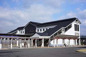 Kamo Station in November 2012 | |||||||||||||||||||||||||||||||||||||||||||||||||||||||||||||||||||||||||||||||||||||||||||||||||||||||
| Location | 1-6-3, Kamochō-ekinishi, Kizugawa (京都府木津川市加茂町駅西1丁目6-3) Kyoto Prefecture Japan | ||||||||||||||||||||||||||||||||||||||||||||||||||||||||||||||||||||||||||||||||||||||||||||||||||||||
| Coordinates | 34°45′10″N 135°52′11″E | ||||||||||||||||||||||||||||||||||||||||||||||||||||||||||||||||||||||||||||||||||||||||||||||||||||||
| Owned by | |||||||||||||||||||||||||||||||||||||||||||||||||||||||||||||||||||||||||||||||||||||||||||||||||||||||
| Operated by | |||||||||||||||||||||||||||||||||||||||||||||||||||||||||||||||||||||||||||||||||||||||||||||||||||||||
| Line(s) |
| ||||||||||||||||||||||||||||||||||||||||||||||||||||||||||||||||||||||||||||||||||||||||||||||||||||||
| Distance | |||||||||||||||||||||||||||||||||||||||||||||||||||||||||||||||||||||||||||||||||||||||||||||||||||||||
| Platforms | 2 island platforms | ||||||||||||||||||||||||||||||||||||||||||||||||||||||||||||||||||||||||||||||||||||||||||||||||||||||
| Tracks | 4 (1 storage) | ||||||||||||||||||||||||||||||||||||||||||||||||||||||||||||||||||||||||||||||||||||||||||||||||||||||
| Train operators | |||||||||||||||||||||||||||||||||||||||||||||||||||||||||||||||||||||||||||||||||||||||||||||||||||||||
| Bus stands | 2 | ||||||||||||||||||||||||||||||||||||||||||||||||||||||||||||||||||||||||||||||||||||||||||||||||||||||
| Connections |
| ||||||||||||||||||||||||||||||||||||||||||||||||||||||||||||||||||||||||||||||||||||||||||||||||||||||
| Construction | |||||||||||||||||||||||||||||||||||||||||||||||||||||||||||||||||||||||||||||||||||||||||||||||||||||||
| Structure type | At grade | ||||||||||||||||||||||||||||||||||||||||||||||||||||||||||||||||||||||||||||||||||||||||||||||||||||||
| Bicycle facilities | |||||||||||||||||||||||||||||||||||||||||||||||||||||||||||||||||||||||||||||||||||||||||||||||||||||||
| Disabled access | Yes (2 elevators for the ticket gate, 1 elevator for each platform and 1 accessible bathroom) | ||||||||||||||||||||||||||||||||||||||||||||||||||||||||||||||||||||||||||||||||||||||||||||||||||||||
| Other information | |||||||||||||||||||||||||||||||||||||||||||||||||||||||||||||||||||||||||||||||||||||||||||||||||||||||
| Station code | Q39 | ||||||||||||||||||||||||||||||||||||||||||||||||||||||||||||||||||||||||||||||||||||||||||||||||||||||
| Website | Official website | ||||||||||||||||||||||||||||||||||||||||||||||||||||||||||||||||||||||||||||||||||||||||||||||||||||||
| History | |||||||||||||||||||||||||||||||||||||||||||||||||||||||||||||||||||||||||||||||||||||||||||||||||||||||
| Opened | 11 November 1897 | ||||||||||||||||||||||||||||||||||||||||||||||||||||||||||||||||||||||||||||||||||||||||||||||||||||||
| Traffic | |||||||||||||||||||||||||||||||||||||||||||||||||||||||||||||||||||||||||||||||||||||||||||||||||||||||
| Passengers (2016) | 2,359 | ||||||||||||||||||||||||||||||||||||||||||||||||||||||||||||||||||||||||||||||||||||||||||||||||||||||
| |||||||||||||||||||||||||||||||||||||||||||||||||||||||||||||||||||||||||||||||||||||||||||||||||||||||
Lines
Layout
The station has two island platforms with three tracks on the ground level.
Platforms
| 1 | ■ Yamatoji Line–Local | for Ōji, and Nara |
| ■ Yamatoji Line—Regional Rapid Service | for Ōsaka | |
| ■ Yamatoji Line—Rapid Service | for JR Namba | |
| ■ Yamatoji Line—Yamatoji Rapid Service | for Ōsaka | |
| 2 | ■ Kansai Line | for Kameyama, Tsuge, and Iga-Ueno |
| 3 | ■ Yamatoji Line—Local | for JR Namba and Nara (1st train and 4th to last train only) |
| ■ Yamatoji Line—Rapid Service | for JR Namba (5th to last train only) | |
| 4 | ■ Yamatoji Line—Local | for Nara (9th train only) |
| ■ Yamatoji Line—Regional Rapid Service | for Ōsaka (4th and 7th trains only) | |
| ■ Yamatoji Line—Rapid Service | for JR Namba (2nd and 6th trains only) | |
| ■ Yamatoji Line—Yamatoji Rapid Service | for Ōsaka (2nd, 4th, and 8th trains only) | |
| ■ Kansai Line | for Kameyama (1st train and 3rd to last train only) | |
| ■ Kansai Line | Storage track |
History
The station opened in 1897 as a station on the Kansai Railway, which connected Osaka and Nagoya via Nara. The Kansai Railway was nationalized in 1907 and became the Kansai Main Line. With the privatization of Japanese National Railways (JNR) on 1 April 1987, the station came under the control of JR West.
Passenger statistics
According to the Kyoto Prefecture statistical book, the average number of passengers per day is as follows.
| Year | Passengers |
|---|---|
| 1999 | 2,945 |
| 2000 | 3,008 |
| 2001 | 3,126 |
| 2002 | 3,077 |
| 2003 | 3,058 |
| 2004 | 3,093 |
| 2005 | 3,134 |
| 2006 | 3,079 |
| 2007 | 3,014 |
| 2008 | 2,967 |
| 2009 | 2,825 |
| 2010 | 2,740 |
| 2011 | 2,623 |
| 2012 | 2,581 |
| 2013 | 2,556 |
| 2014 | 2,430 |
| 2015 | 2,385 |
| 2016 | 2,359 |
See also
External links
| Wikimedia Commons has media related to Kamo Station (Kyoto). |
- Official website (in Japanese)