Kamenná Horka
Kamenná Horka (German: Hermersdorf) is a village and municipality (obec) in Svitavy District in the Pardubice Region of the Czech Republic. The village lies on the border between the historical regions of Bohemia and Moravia.
Kamenná Horka | |
|---|---|
Municipality | |
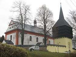 Church of Saint Mary Magdalene | |
 Flag  Coat of arms | |
 Kamenná Horka | |
| Coordinates: 49°44′40″N 16°32′41″E | |
| Country | |
| Region | Pardubice |
| District | Svitavy |
| Area | |
| • Total | 15.75 km2 (6.08 sq mi) |
| Elevation | 521 m (1,709 ft) |
| Population (1.1.2014) | |
| • Total | 297 |
| • Density | 19/km2 (49/sq mi) |
| Postal code | 568 02 |
| Website | https://www.obeckamennahorka.cz/ |
The municipality covers an area of 15.75 square kilometres (6.08 sq mi), and has a population of 287 (as at 3 July 2006).
Kamenná Horka lies approximately 6 kilometres (4 mi) east of Svitavy, 64 km (40 mi) south-east of Pardubice, and 157 km (98 mi) east of Prague.
This article is issued from Wikipedia. The text is licensed under Creative Commons - Attribution - Sharealike. Additional terms may apply for the media files.