Kamalia
Kamalia (Urdu/Punjabi: کمالیہ) is a city in the Toba Tek Singh District of Punjab, Pakistan. It is the administrative center of Kamalia Tehsil.[2] It is the 66th largest city of Pakistan by population.
Kamalia | |
|---|---|
City | |
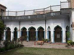 Historic Saad Manzil | |
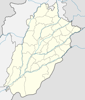 Kamalia Location in Pakistan  Kamalia Kamalia (Pakistan) | |
| Coordinates: 30°44′N 72°39′E | |
| Country | |
| Province | |
| Division | Faisalabad |
| District | Toba Tek Singh |
| Tehsil | Kamalia |
| Union Councils | 13 |
| Population | |
| • City | 135,641 |
| • Rank | 66th, Pakistan |
| Time zone | UTC+5 |
| • Summer (DST) | UTC+6 (PDT) |
| Area code(s) | 046 |
| Website | Town Municipal Administration Kamalia |
Demography
| 1961 | 1972 | 1981 | 2010 |
|---|---|---|---|
| 35 248 | 50 934 | 61 107 | 124 154 |
References
- "PAKISTAN: Provinces and Major Cities". PAKISTAN: Provinces and Major Cities. citypopulation.de. Retrieved 4 May 2020.
- Miraj, Muhammad Hassan (16 September 2013). "The Kot of Kamalia". Dawn. Retrieved 21 May 2017.
- [population-statistics.com/wg.php?x=1263333481&men=gpro&lng=es&des=wg&geo=-172&srt=npan&col=abcdefghinoq&msz=1500&pt=c&va=&geo=434653264 "Population statistics"] Check
|url=value (help).
This article is issued from Wikipedia. The text is licensed under Creative Commons - Attribution - Sharealike. Additional terms may apply for the media files.