Jomsom
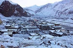
Jomsom (Nepali: जोमसोम), also known as Dzong-Sampa or New Fort, is the centre of Gharpajhong Gaunpalika and former independent village development committee at an altitude of about 2,700 metres (8,900 ft) in Mustang District, Nepal. It extends over both the banks of the Kali Gandaki River. Along the banks of Kali Gandaki river, black rocks or stones called shaligram in the Hindu culture can be found, which locals see as the form of God Vishnu. This type of stone is only found in this Kali Gandaki River but people are unknown about it so, it is holy to the Hindus. The soaring peaks of Dhaulagiri and Nilgiri form a backdrop. As the district headquarters, it is primarily an administrative and commercial center with government officials and merchants rubbing shoulders with the local residents of the region, known as Thakalis. A company of the Nepalese Army is stationed here. Nearby is Jomsom Airport from where there are regular flights.
Jomsom जोमसोम | |
|---|---|
 | |
 Jomsom Location in Nepal | |
| Coordinates: 28°47′0″N 83°43′50″E | |
| Country | |
| Province | Gandaki |
| District | Mustang District |
| Elevation | 2,743 m (8,999 ft) |
| Population (2011)[1] | |
| • Total | 1,370 |
| Time zone | UTC+5:45 (NST) |
| Postal code | 33100 |
| Area code(s) | 069 |


Geography
A trail passes through the Lower Mustang region of Nepal, ending at the village of Kagbeni, a Tibetan influenced village filled with prayer wheels, chortens and a Buddhist monastery. The trail follows the Kali Gandaki River which forms the deepest ravine in the world; on one side lies the Annapurna mountain range and on the other side is Dhaulagiri. Between the two ranges, there are views of 8 of the 20 highest mountains in the world. The Kali Gandaki is a quarter of a mile wide river bed; during the winter the river will be frozen, but during the summer and monsoon it fills with rainwater and melting snow. The scenery of the trail ranges from forests of bright Rhododendrons (Nepali: लालीगुँरास) to rocky cliffs. The culture along the track is a rich combination of Hindu and Tibetan Buddhism. The trail's highest point is Muktinath at 3800 m, a holy site of temples sacred to both Buddhists and Hindus for centuries.
Jomsom trek
A Jomsom trek (north of Pokhara) reveals Nepal's spectacular diversity. The deep valleys and high mountains encircling the giant Annapurna Himal embrace a wide range of peoples and terrain, from subtropical jungle to a high, dry landscape resembling the Tibetan Plateau. The Annapurna region is the most the popular trekking area in Nepal with plenty of trekking places, attracting over 75% of all trekkers (more than 30,000 annually). It's also among the tamest areas, with excellent lodges lining the main routes.
Media
A modern FM radio broadcasting station was built in Jomsom in September, 2013. It is equipped with one radio studio, one main control room and the transmission tower along with the community center and camping site for Annapurna trekkers. The station was built and contributed by a major Korean broadcaster, MBC, Lafuma and KOICA for the wellbeing and safety of both residents and trekkers of Mustang.
2015 Nepal earthquake
The town was only slightly affected by the major earthquake on 25 April 2015. However, 15–20 buildings along the river bank were damaged by a slowly progressing landslide after the earthquake. No injuries were reported in the town.[2][3]
See also
References
- "National Population and Housing Census 2011" (PDF). Central Bureau of Statistics. November 2017. Archived from the original (PDF) on 27 January 2018. Retrieved 1 May 2018.
- "Nepal earthquake: Yarra Valley woman Taisha Reed talks of her narrow escape". Sydney Morning Herald. Sydney Morning Herald. 30 April 2015. Archived from the original on 1 May 2015. Retrieved 17 November 2016.
- "Two Nelson photographers survive Nepal earthquake". Nelson Star. 25 April 2015. Archived from the original on 1 May 2015. Retrieved 17 November 2016.
Headquarters: Jomsom (today part of Gharpajhong Rural Municipality) | ||
| Rural municipalities |
|  |