Jokkmokk
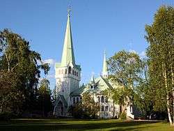
Jokkmokk (Swedish: [ˈjɔ̌kːmɔk];[2] Lule Sami: Jåhkåmåhkke or Dálvvadis;[3] Northern Sami: Dálvvadis; Finnish: Jokimukka) is a locality and the seat of Jokkmokk Municipality in Norrbotten County, province of Lapland, Sweden, with 2,786 inhabitants in 2010.[1] The Sámi name of the place (composed of the individual words jåhkå and måhkke) means "River's Curve," due to the meandering river that runs through it.[3] It is just north of the Arctic Circle. Talvatissjön is located at the southern part of Jokkmokk.[3]
Jåhkåmåhkke/Jokkmokk | |
|---|---|
 | |
 Jåhkåmåhkke/Jokkmokk  Jåhkåmåhkke/Jokkmokk | |
| Coordinates: 66°37′N 19°50′E | |
| Country | Sweden |
| Province | Lapland |
| County | Norrbotten County |
| Municipality | Jokkmokk Municipality |
| Area | |
| • Total | 3.59 km2 (1.39 sq mi) |
| Population (31 December 2010)[1] | |
| • Total | 2,786 |
| • Density | 776/km2 (2,010/sq mi) |
| Time zone | UTC+1 (CET) |
| • Summer (DST) | UTC+2 (CEST) |
Jokkmokk is an important locality for Sámi people and the location of several institutions related to them, including an education centre, the Ájtte museum, and an office of the Sámi Parliament of Sweden.[3]
Jokkmokk was a transit center for Sami refugees from Norway during World War II, in addition to the centre in Kjesäter.
Jokkmokk Market has been taking place for more than 400 years. On the first Thursday in February every year, thousands of people gather in the town for concerts, exhibitions and trade in one of the most important social events for the Sámi people in Sápmi. Temperatures during the festival can drop as low as −40°.
Climate
Influenced by its inland and northerly position, Jokkmokk's variety of a subarctic climate is very cold by Swedish standards. Summers are normally relatively mild in spite of the day-round light and the dark winters are long and cold.
| Climate data for Jokkmokk, 1971-2000 | |||||||||||||
|---|---|---|---|---|---|---|---|---|---|---|---|---|---|
| Month | Jan | Feb | Mar | Apr | May | Jun | Jul | Aug | Sep | Oct | Nov | Dec | Year |
| Record high °C (°F) | 9.2 (48.6) |
8.1 (46.6) |
12.3 (54.1) |
19.2 (66.6) |
28.5 (83.3) |
31.2 (88.2) |
34.5 (94.1) |
30.5 (86.9) |
23.2 (73.8) |
18.5 (65.3) |
10.8 (51.4) |
7.5 (45.5) |
34.5 (94.1) |
| Average high °C (°F) | −9.3 (15.3) |
−7.7 (18.1) |
−1.8 (28.8) |
3.5 (38.3) |
10.5 (50.9) |
16.5 (61.7) |
19.2 (66.6) |
16.3 (61.3) |
10.3 (50.5) |
3.3 (37.9) |
−4.6 (23.7) |
−8.2 (17.2) |
4.0 (39.2) |
| Daily mean °C (°F) | −14.8 (5.4) |
−12.9 (8.8) |
−7.5 (18.5) |
−1.2 (29.8) |
5.6 (42.1) |
11.8 (53.2) |
14.5 (58.1) |
11.9 (53.4) |
6.4 (43.5) |
0.2 (32.4) |
−8.4 (16.9) |
−13.2 (8.2) |
−0.6 (30.9) |
| Average low °C (°F) | −20.2 (−4.4) |
−18.4 (−1.1) |
−13.4 (7.9) |
−6.3 (20.7) |
0.4 (32.7) |
6.9 (44.4) |
9.8 (49.6) |
7.8 (46.0) |
2.8 (37.0) |
−3.0 (26.6) |
−12.6 (9.3) |
−18.1 (−0.6) |
−5.4 (22.3) |
| Record low °C (°F) | −46.0 (−50.8) |
−42.6 (−44.7) |
−36.8 (−34.2) |
−29.0 (−20.2) |
−14.5 (5.9) |
−5.5 (22.1) |
0.4 (32.7) |
−4.0 (24.8) |
−12.0 (10.4) |
−24.6 (−12.3) |
−35.5 (−31.9) |
−41.0 (−41.8) |
−46.0 (−50.8) |
| Average precipitation mm (inches) | 31.4 (1.24) |
21.8 (0.86) |
24.3 (0.96) |
22.3 (0.88) |
37.0 (1.46) |
57.7 (2.27) |
84.3 (3.32) |
69.3 (2.73) |
45.0 (1.77) |
40.3 (1.59) |
40.0 (1.57) |
30.6 (1.20) |
504 (19.85) |
| Source: [4] | |||||||||||||
See also
References
| Wikimedia Commons has media related to Jokkmokk. |
- "Tätorternas landareal, folkmängd och invånare per km2 2005 och 2010" (in Swedish). Statistics Sweden. 14 December 2011. Archived from the original on 10 January 2012. Retrieved 10 January 2012.
- Jöran Sahlgren; Gösta Bergman (1979). Svenska ortnamn med uttalsuppgifter (in Swedish). p. 12 – via Project Runeberg.
- "Jokkmokk". Swedish Institute for Language and Folklore (in Swedish). Retrieved 5 November 2019.
- "SMHI". Archived from the original on 2013-10-20.
External links
Municipalities and seats of Norrbotten County | ||
|---|---|---|
| Municipalities | ||
| Municipal seats | ||
| Authority control |
|
|---|