Johnson, Vermont
Johnson is a town in Lamoille County, Vermont, United States. The population was 3,446 at the 2010 census. Johnson is home of Northern Vermont University-Johnson, a part the Vermont State Colleges system. The Vermont Studio Center is located in the village of Johnson.
Johnson, Vermont | |
|---|---|
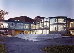 Northern Vermont University-Johnson | |
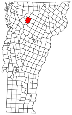 Located in Lamoille County, Vermont | |
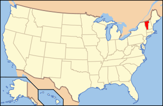 Location of Vermont within the U.S.A. | |
 Johnson, Vermont Location in the United States | |
| Coordinates: 44°38′38″N 72°40′52″W[1] | |
| Country | United States |
| State | Vermont |
| County | Lamoille |
| Chartered | 1792 (Vermont)[2] |
| Communities | Johnson East Johnson |
| Area | |
| • Total | 45.1 sq mi (116.8 km2) |
| • Land | 45.1 sq mi (116.8 km2) |
| • Water | >1 sq mi (>1 km2) 0.02% |
| Population (2010) | |
| • Total | 3,446 |
| • Density | 72.6/sq mi (28.0/km2) |
| • Households | 1,170 |
| • Families | 669 |
| Time zone | UTC-5 (EST) |
| • Summer (DST) | UTC-4 (EDT) |
| ZIP code | 05656 |
| Area code(s) | 802 |
| GNIS feature ID | 1462129 |
| Website | Johnson Vermont Official Website |
Geography
According to the United States Census Bureau, the town has a total area of 45.1 square miles (116.8 km2), of which 45.1 square miles (116.8 km2) is land and 0.02% is water.
Town name
According to Esther Munroe Swift's book "Vermont Place-names: Footprints of History" the town of Johnson is named for the American jurist, statesman and educator William Samuel Johnson. Johnson, Vermont and a part of neighboring Cambridge, Vermont were together known as King's College Tract being created by a royal charter of British King George III in 1774. The King's College Tract was reserved for the eventual expansion of Kings College in New York, today's Columbia University. After the Declaration of Independence, Vermont's Council of Censors granted the town to Johnson in 1785.
Demographics
| Historical population | |||
|---|---|---|---|
| Census | Pop. | %± | |
| 1790 | 93 | — | |
| 1800 | 341 | 266.7% | |
| 1810 | 494 | 44.9% | |
| 1820 | 778 | 57.5% | |
| 1830 | 1,079 | 38.7% | |
| 1840 | 1,410 | 30.7% | |
| 1850 | 1,381 | −2.1% | |
| 1860 | 1,526 | 10.5% | |
| 1870 | 1,558 | 2.1% | |
| 1880 | 1,495 | −4.0% | |
| 1890 | 1,462 | −2.2% | |
| 1900 | 1,391 | −4.9% | |
| 1910 | 1,526 | 9.7% | |
| 1920 | 1,478 | −3.1% | |
| 1930 | 1,378 | −6.8% | |
| 1940 | 1,420 | 3.0% | |
| 1950 | 1,527 | 7.5% | |
| 1960 | 1,478 | −3.2% | |
| 1970 | 1,927 | 30.4% | |
| 1980 | 2,581 | 33.9% | |
| 1990 | 3,156 | 22.3% | |
| 2000 | 3,274 | 3.7% | |
| 2010 | 3,446 | 5.3% | |
| Est. 2018 | 3,614 | [3] | 4.9% |
| U.S. Decennial Census[4] | |||
As of the census[5] of 2000, there were 3,274 people, 1,170 households, and 669 families residing in the town. The population density was 72.6 people per square mile (28.0/km2). There were 1,263 housing units at an average density of 28.0 per square mile (10.8/km2). The racial makeup of the town was 96.58% White, 0.61% Black or African American, 0.43% Native American, 0.67% Asian, 0.31% from other races, and 1.41% from two or more races. Hispanic or Latino of any race were 0.73% of the population.
There were 1,170 households, out of which 30.8% had children under the age of 18 living with them, 41.4% were couples living together and joined in either marriage or civil union, 10.8% had a female householder with no husband present, and 42.8% were non-families. 28.2% of all households were made up of individuals, and 8.5% had someone living alone who was 65 years of age or older. The average household size was 2.43 and the average family size was 2.99.
In the town, the population was spread out, with 21.6% under the age of 18, 26.4% from 18 to 24, 25.4% from 25 to 44, 18.2% from 45 to 64, and 8.5% who were 65 years of age or older. The median age was 26 years. For every 100 females, there were 103.7 males. For every 100 females age 18 and over, there were 102.2 males.
The median income for a household in the town was $31,343, and the median income for a family was $38,224. Males had a median income of $28,257 versus $20,610 for females. The per capita income for the town was $15,014. About 13.8% of families and 18.9% of the population were below the poverty line, including 21.6% of those under age 18 and 11.7% of those age 65 or over.
References
- "Town of Johnson". Geographic Names Information System. United States Geological Survey. Retrieved 2009-05-15.
- "Archived copy". Archived from the original on 2012-04-06. Retrieved 2011-12-20.CS1 maint: archived copy as title (link)
- "Population and Housing Unit Estimates". Retrieved January 23, 2020.
- "U.S. Decennial Census". United States Census Bureau. Retrieved May 16, 2015.
- "U.S. Census website". United States Census Bureau. Retrieved 2008-01-31.
- Rodgers, Steve. Country Towns of Vermont. McGraw-Hill: 1998. ISBN 1-56626-195-3.
- Strickland, Ron. Vermonters: Oral Histories from Down Country to the Northeast Kingdom. University Press of New England: 1986. ISBN 0-87451-867-9.
- Swift, Esther Monroe. Vermont Place Names: Footprints of History. The Stephen Greene Press: 1996 ISBN 0-8289-0291-7.
External links
- Johnson Vermont Official Town Website
- Johnson Woolen Mills
- Johnson State College
- Vermont Studio Center
- The Johnson Connection: A Business listing site with information about the town.
Municipalities and communities of Lamoille County, Vermont, United States | ||
|---|---|---|
Shire town: Hyde Park | ||
| Towns |  Map of Vermont highlighting Lamoille County | |
| Villages | ||
| CDP |
| |
| Unincorporated communities | ||
| Authority control |
|
|---|