Jeungpyeong County
Jeungpyeong County (Jeungpyeong-gun) is a county in North Chungcheong Province, South Korea.
Jeungpyeong 증평군 | |
|---|---|
County | |
| Korean transcription(s) | |
| • Hangul | 증평군 |
| • Hanja | 曾坪郡 |
| • Revised Romanization | Jeungpyeong-gun |
| • McCune-Reischauer | Chŭngp'yŏng-gun |
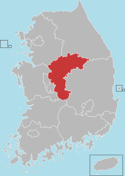
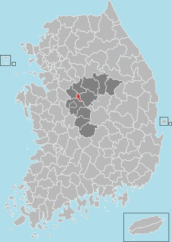 Location in South Korea | |
| Country | |
| Region | Hoseo |
| Administrative divisions | 1 eup, 1 myeon |
| Area | |
| • Total | 81.84 km2 (31.60 sq mi) |
| Population (2008) | |
| • Total | 31,276 |
| • Density | 382/km2 (990/sq mi) |
| • Dialect | Chungcheong |
| Website | jp.go.kr |
Location
Jeungpyeong is in the centrally located in Chungcheongbuk-do. It is located East of Jincheon, West of Goesan, south of Eumseong, north of Cheongwon.
History
- 1990, 12, 31 : Chungcheongbuk-do JeungPyeong local office is construct of Goesan-gun jeungpyeong eup, doan myeon.
- 2003, 8, 30 : Jeungpyeong local office is raised to Jeungpyeong-gun, and it became independence from Goesan-gun.
Education
- JeungPyeong is the site of several school and tertiary institution, including:
Elementary school
- JeungpYeong Elementary School]
- SamBo Elementary School]
- DoAn Elementary School]
- JukRi Elementary School
Middle school
- HyeongSeok Middle School]
- JeungpYeong Informations High School]
- JeungpYeong Technical High School]
High school
- HyeongSeok High School
- JeungpYeong Informations High School
- JeungpYeong Girl's Middle School
Tertiary Institution
This article is issued from Wikipedia. The text is licensed under Creative Commons - Attribution - Sharealike. Additional terms may apply for the media files.