Japan National Route 58
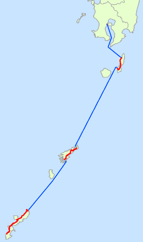
National Route 58 (国道58号) is a highway in Japan. This very unusual road has continuous numbering over disconnected segments on the islands of Kyūshū, Tanegashima, Amami Ōshima, and Okinawa. The road has a total of 255.5 km on land. It originates in the prefectural capital of Kagoshima in Kagoshima Prefecture and terminates in Naha, the capital of Okinawa Prefecture.
| ||||
|---|---|---|---|---|
| 国道58号 | ||||
 | ||||
| Route information | ||||
| Length | 255.5 km[1] (158.8 mi) | |||
| Major junctions | ||||
| From | ||||
| To | ||||
| Section 1 | ||||
| From | Route 3 / Route 10 in Kagoshima | |||
| To | Port of Kagoshima | |||
| Section 2 | ||||
| From | Nishinoomote, Kagoshima | |||
| To | Minamitane, Kagoshima | |||
| Section 3 | ||||
| From | Amami, Kagoshima | |||
| To | Setouchi, Kagoshima | |||
| Section 4 | ||||
| From | Kunigami, Okinawa | |||
| Major junctions | ||||
| To | Route 330 / Route 331 / Route 390 in Naha, Okinawa | |||
| Highway system | ||||
| National highways of Japan Expressways of Japan
| ||||
At the northern terminus, Route 58 meets Routes 3 and 10. The segment in the city of Kagoshima measures only about 700 m. The next segment links Nishinoomote, Nakatane, and Minamitane. On Amami Ōshima, the highway connects Amami, Tatsugo, and Setouchi. The final segment starts in Kunigami at the northern tip of Okinawa Island and runs along the west coast to the southern terminus in Naha.
References
- "一般国道の路線別、都道府県別道路現況" [Road statistics by General National Highway route and prefecture] (PDF) (in Japanese). Ministry of Land, Infrastructure, Transport and Tourism. Retrieved 19 February 2020.
| Wikimedia Commons has media related to Route 58 (Japan). |