Jalalpur Jattan
Jalalpur Jattan (Urdu: جلالپور جٹاں) is a city in Gujrat District in the province of Punjab, Pakistan. It is the centre of Jalalpur Jattan Tehsil and is about 50 km away from Kashmir.[1]
Jalalpur Jattan جلالپور جٹاں | |
|---|---|
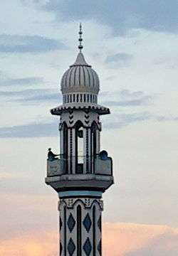 Saqib Minar is the notable tower of the city | |
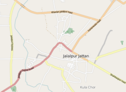 Map of Jalalpur Jattan | |
| Coordinates: 32°38′31.0″N 74°12′11.9″E | |
| Country | |
| Province | Punjab |
| District | Gujrat |
| Population (17.01.2012) | |
| • Total | 93,883 |
| Time zone | UTC+5 (PST) |
| Calling code | 053 |
History
When Alexander the Great defeated King Porus,[2] he established two towns one near Jehlum river and another near Chenab river. The latter, present day Jalalpur Jattan was named Shaklanagar an amalgamation of Greek and Sanskrit words meaning the city of beauty.[3] These cities were settled by people from his multinational armies, which included a majority of Greeks. These Indo-Greek cities and their associated realms thrived long after Alexander's departure. Later, Jalal ud din Firuz Khalji and his forces stayed here to suppress the invasion of Mongols and he renamed the city to Jalalabad after his name. The name was once again changed to Jalalpur Jattan by the notable Jatts of their time said to be Zabardast Khan and Ajmer Khan.[4]
During Sikh Empire, the town gained significant importance. There is a place in Jalalpur Jattan built by Chandragupta Maurya in 300 BC.[4] Local historians believe that Chandragupta had built a fort in Islam Garh, a suburban village of Jalalpur Jattan. The original name of the village could not be ascertained but the fort became famous as Islam Garh Fort with the passage of time. The fort of Islam Garh had remained under Aurangzeb Alamgir, Ahmed Shah Abdali, and Ranjit Singh and their forces.[4] The fort had been the mint of Maharaja Ranjit Singh of Lahore in 1832. Only some deteriorated remains of the fort exists today.
There is also an ancient city within the territories of the city, now a town known as Kula Chor. Excavations in the area revealed that Kula Chor was the mint of the Maurya Dynasty.[5]
In 1908, Jalalpur Jattan was made a municipality or municipal committee, the fully representative body.[6][7] The city was granted tehsil status in November but it still in process due to lack of interest. 2016.[8]
Climate


The town has moderate climate. The average temperature of the city is 23.9 °C. During the peak of summer, the daytime temperature shoots up to 45 °C, but the hot spells are relatively short due to the proximity of the Azad Kashmir mountains. During the winter, the minimum temperature may fall below 2 °C. The rainfall in the city is remarkable, with precipitation even during the parched months. The average rainfall is 802 mm.[9]
Economy

The city is famous for its cottage industry of textile[10] and its local sweets called Khatai. Jalalpur Jattan connects Gujrat with multiple cities through the Jalalpur–Gujrat Road.
Jalalpur Jattan is head office of the Sadar Circle Gujrat.
Cantonment
Jalapur Jattan has a small cantonment area, which has its importance due to its proximity with the line of control and important strategic cities of Azad Kashmir like Chamb, Kot Jamil and important headworks of river Chenab such as Head Marala.
Notable people
- Farrukh Gondal, Businessman
- Ejaz Durrani, actor
- Rajendra Krishan, songwriter
References
- Tehsils & Unions in the District of Gujrat – Government of Pakistan Archived 2009-02-14 at the Wayback Machine
- http://www.encyclopedia.com/topic/Alexander_the_Great.aspx
- "History of Jalalpur Jattan". vojpj.com.
- "جلالپور جٹاں کی تاریخ" [History of Jalalpur Jattan]. vojpj.com.
- Historical sites in Gujrat crumbling – Daily Times Pakistan
- Butt, Waseem Ashraf (10 November 2013). "Gujrat reverts to municipal committee status". Dawn. Retrieved 20 October 2019.
- Waseem Ashraf Butt. "Gujrat may get municipal corporation status". dawn.com.
- Waseem Ashraf Butt. "Jalalpur Jattan notified as tehsil". dawn.com.
- en.climate-data.org/location/28949/
- "Archived copy". Archived from the original on 18 May 2015. Retrieved 25 April 2015.CS1 maint: archived copy as title (link)