Jacksonville Transportation Authority
The Jacksonville Transportation Authority (JTA) is the independent agency responsible for public transit in the city of Jacksonville, Florida, and roadway infrastructure that connects northeast Florida.[2] However, they do not maintain any roadways.
 | |
| Overview | |
|---|---|
| Locale | Jacksonville, Florida |
| Transit type | Rapid transit and bus |
| Number of lines | 2 (rail) 46 (bus) |
| Number of stations | 8 (rail) |
| Daily ridership | 42,200 weekday (Q3 2012)[1] 5,400 (rail) |
| Website | www.jtafla.com |
| Operation | |
| Began operation | 1971 (buses) 1989 (trains) |
| Operator(s) | Jacksonville Transportation Authority |
| Technical | |
| System length | 2.5 miles (4.0 km) |
History
In 1955, the Florida Legislature established the Jacksonville Expressway Authority. Their responsibility was limited to highways, bridges and tolls in Duval County until 1971, when the Jacksonville Transportation Authority was formed by a merger of the Jacksonville Expressway Authority with several private bus companies.
Governance
The JTA is governed by a seven-member Board of Directors. The mayor of Jacksonville appoints three members who must be confirmed by the Jacksonville City Council; the Florida Governor appoints three members who must be confirmed by the Florida Senate. Each member serves a four-year, unpaid term and can be re-appointed for a second term. If a member serves eight consecutive years, they must rotate off the board. From its membership, the Board elects its own Chairman, Vice Chairman, Secretary and Treasurer for one year terms. The seventh member is the District Two Secretary from the Florida Department of Transportation (FDOT) who serves as long as s/he is employed in the position. That individual is responsible for the FDOT activities within the 18 counties of the district, including administrative, planning and operations.[3]
As of February 2016, members included Scott McCaleb, chairman; Isaiah Rumlin, vice chairman; Kevin Holzendorf, secretary; Ari Jolly, treasurer; Greg Evans, FDOT District Two Secretary; Denise Wallace, board member; and Jeanne Miller, board member.[4]
Revenue
Originally, when a bridge or roadway was completed, a toll was imposed at that location to create a revenue stream to repay bonds used to fund construction. State and federal tax money was used for specific capital projects, such as interstate highways.
Gas surcharge
The Jacksonville City Council approved a 10-year, 6¢ per gallon gasoline surcharge in 1986 to pay for new roadways and other transportation projects. Prior to its expiration in 1996, the council extended the tax for 20 additional years, until 2016.[5]
Tolls
J. Turner Butler Boulevard, the Fuller Warren Bridge, Mathews Bridge, Hart Bridge and Trout River Bridge were tolled by JTA until 1988, when Jacksonville voters approved a ½¢ sales tax increase to pay off the toll bonds, fund future road construction, and abolish toll collections.
Growth management
JTA was the major beneficiary of the $2.25 billion Better Jacksonville Plan (BJP), passed by voters in September, 2000. Roadway/drainage improvements, resurfacing, new sidewalks and railroad grade crossings accounted for $1.5 billion, of which half was funded by the BJP ½¢ sales tax increase and half from the existing gasoline surcharge.[6] In 2005, the JTA and city re-prioritized the projects still outstanding. The actual cost for most projects had significantly exceeded the estimate due to an 18-month lag time and an unanticipated increase in the price of construction materials. Dozens of projects were deferred to the future and removed from the BJP or left on a $320 million list of unfunded tasks.[7]
Budget
The gasoline surcharge generates approximately $30 million in revenue each year, about one third of JTA's budget of $100 million in 2010. Prior to the 1986 gasoline surcharge, tolls were the primary source of local revenue for the JTA. Federal and state highway money provided the balance. In early June, 2010, JTA announced their intentions to request an extension of the 6¢ per gallon gasoline surcharge, due to expire in 2016. They will also ask the council for an additional 5¢ per gallon tax over 30 years that would generate another $25 million per year, for a total of $55 million each year. Most council members questioned the need to extend the existing tax and were opposed to any new tax during difficult economic times, but JTA executives warned that if the gas taxes are curtailed, no road construction will occur and bus service will be slashed.
Responsibilities
The goal of the JTA is to improve the flow of traffic into and throughout Jacksonville/Duval County.
Roadway infrastructure
The JTA develops and implements construction and financing plans for state and city roads, bridges and interchanges in conjunction with the city government and the Florida Department of Transportation. This was the original role of the Expressway Authority.
Public transit
- Regular bus service: JTA's fleet has 220 vehicles, as of 2015, that travel 8.5 million miles per year on 56 routes; 110 maintenance workers and 320 drivers are employed.
- Express bus service: five once-daily early morning routes are offered which originate from an outlying area and go directly to their destination with no intermediate stops, then return in late afternoon.
- First Coast Flyer: a bus rapid transit (BRT) system; three of four planned routes are in operation.[8]
- Trolley-replica buses: local transportation available weekdays from mid-morning to early afternoon; Bay Street and Beaver Street (downtown) routes are free; Riverside and the Beach trolley have a minimal charge but also run on weekends. [9]
- JTA Connexion: paratransit for the disabled and elderly, provided by private vendors with specially equipped vehicles and drivers.
- Stadium shuttle: game day bus transportation from suburban, downtown and Park-n-Ride locations to the stadium and back.
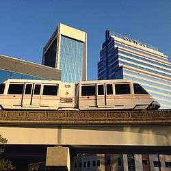
- Jacksonville Skyway: Automated people mover system which travels 2.5 miles from the King Street parking garage across the St. Johns River and through the central business district, ending at the Convention Center or the Florida State College at Jacksonville downtown campus.
- Park-n-Ride: Parking facility available in combination with express bus service or JTA Skyway.
Future transit
- First Coast Flyer: One additional routes is planned for the First Coast Flyer BRT system.[8]
- First Coast Commuter Rail: JTA is undertaking evaluations for a future commuter rail system.[11]
- Jacksonville Skyway Modernization Program: JTA is undertaking a project to modernize the Skyway with new equipment.[12]
- Jacksonville Regional Transportation Center (JRTC): JTA has approved and is helping to build a new intermodal transit center, which is ultimately planned to bring together Jacksonville Skyway, JTA bus, First Coast Flyer, intercity bus, and rail service in one facility. JRTC will be situated around the Prime F. Osborn III Convention Center.[13]
Hurricanes
The JTA has the responsibility to identify, plan and prepare Jacksonville's hurricane evacuation routes. The JTA and the city of Jacksonville established a Hurricane Preparedness Plan that will provide emergency evacuation/patient transport and move civilians and/or emergency service personnel with mass transit.[14]
Routes
On December 1, 2014, JTA underwent a complete system redesign called Route Optimization. This was to provide more frequent, more direct, and more reliable service. The current routes as follows. [15]
Local Bus Routes
- 1 North Main
- 3 Moncrief
- 4 Kings
- 5 Park / Blanding (will be converted to First Coast Flyer and renamed route 105 First Coast Flyer Purple in December 2020)
- 8 Beach / Town Center
- 10 Atlantic
- 11 A. Philip Randolph
- 12 Myrtle / Lem Turner
- 13 Commonwealth / Lane
- 14 Edison
- 15 Post / Normandy
- 16 Riverside / Wilson
- 17 St. Augustine
- 18 Atlantic / Monument
- 19 Arlington
- 21 Boulevard/ Gateway
- 22 Avenue B
- 23 Townsend / Southside
- 24 Mayport
- 25 San Jose
- 26 Collins (service west of Rampart Road replaced by ReadiRide Oakleaf on December 2, 2019)[16]
- 27 Philips / Avenues
- 28 Southside / Sunbeam
- 30 Cecil / Blanding (renamed from 30 Cecil on December 5, 2016; sections replaced by ReadiRide Southwest on December 3, 2018)
- 32 McDuff
- 33 Spring Park / Philips
- 50 University
- 51 Edgewood
- 53 Commonwealth / Cassat
- 80 NAS Shuttle
- 81 Dinsmore Shuttle
- 82 Armsdale / Duval
- 84 Philips / Gran Bay
- 85 Highlands / Busch Drive
- 86 Northside
- 102 First Coast Flyer Green
- 107 First Coast Flyer Blue
- 109 First Coast Flyer Red
- 500 St Johns River Ferry
Trolleys
- 71 Riverside/Avondale Night Trolley (only runs the first full weekend of the month, on Friday and Saturday from 6pm until 2am)[17]
Express Routes
- 200 Mandarin Express
- 201 Clay Regional Express
- 202 Mayport Express
- 205 Beaches Express
Former Routes
- 2 Lem Turner (converted to First Coast Flyer and renamed route 102 First Coast Flyer Green on December 7, 2015; local stops served by extended route 12 and new route 21)[18]
- 7 Philips (converted to First Coast Flyer and renamed route 107 First Coast Flyer Blue on December 5, 2016; local stops served by new route 27)[19]
- 9 Arlington / Beach (converted to First Coast Flyer and renamed route 109 First Coast Flyer Red on December 3, 2018; local stops served by routes 8, 10, and new Coastal Cab Southside service, which was replaced by ReadiRide Southside on July 1, 2019)[20]
- 31 Talleyrand (Replaced by ReadiRide Talleyrand on December 2, 2019)[21]
- 34 Blanding / Edgewood (mostly merged into route 30 on December 5, 2016; rest discontinued)
- 35 Sunbeam / Baymeadows (combined with part of route 23 to form new route 28 Southside / Sunbeam on December 3, 2018)
- 70 Beaches Trolley (Discontinued in September 2016; only ran from May-September each year; replaced by Beachside Buggies service)[22]
- 83 Soutel / Pritchard (Replaced by ReadiRide Pritchard on December 2, 2019)[23]
- 203 NAS Shuttle (renumbered route 80 on December 5, 2016)
- 204 Dinsmore Shuttle (renumbered route 81 on December 5, 2016)
- 300 Dunn / Pritchard Community Shuttle (replaced by new route 83 Soutel / Pritchard on December 3, 2018; rest covered by route 81)
- 301 Oakleaf Community Shuttle (replaced by new route 26 Collins on December 3, 2018)
- 302 Southeast Community Shuttle (replaced by new route 84 Philips / Gran Bay and new ReadiRide Southeast on December 3, 2018)
- 303 Beaches Community Shuttle (replaced by ReadiRide Beaches on December 3, 2018)
- 304 Mandarin Community Shuttle (discontinued on December 3, 2016 due to low ridership; restored on May 8, 2017 as Coastal Cab service; this service was replaced by ReadiRide Mandarin on July 1, 2019)[24]
- 305 Highlands Community Shuttle (replaced by new route 85 Highlands / Busch Drive and new ReadiRide Highlands on December 3, 2018)
- 306 Heckscher Community Shuttle (merged into route 305 in August 2015)
- 307 Northside Community Shuttle (replaced by new route 86 Northside and new ReadiRide Northside on December 3, 2018)
- 308 Arlington Community Shuttle (replaced by Coastal Cab service on December 3, 2018; this service was replaced by ReadiRide Arlington July 1, 2019)
First Coast Commuter Rail
| First Coast Commuter Rail | |||||||||||||||||||||||||||||||||||||||||||||||||||||||||||||||||||||||||||||||||||||||||||||||||||||||||||||||||||||||||||||||||||||||||||||||||||||||||||||||||||||||||||||||||||||||||||||||||||||||||||||||||||||||||||||||||||||||||||||||||||||||||||||||||||||||||||||||||||||||||||||||||||||||||||||||||||||||||||||||||||||||||||||||||||||||||||||||||||||||||||||||||||||||||||||||||||||||||||||||||||||||||||||||||||||
|---|---|---|---|---|---|---|---|---|---|---|---|---|---|---|---|---|---|---|---|---|---|---|---|---|---|---|---|---|---|---|---|---|---|---|---|---|---|---|---|---|---|---|---|---|---|---|---|---|---|---|---|---|---|---|---|---|---|---|---|---|---|---|---|---|---|---|---|---|---|---|---|---|---|---|---|---|---|---|---|---|---|---|---|---|---|---|---|---|---|---|---|---|---|---|---|---|---|---|---|---|---|---|---|---|---|---|---|---|---|---|---|---|---|---|---|---|---|---|---|---|---|---|---|---|---|---|---|---|---|---|---|---|---|---|---|---|---|---|---|---|---|---|---|---|---|---|---|---|---|---|---|---|---|---|---|---|---|---|---|---|---|---|---|---|---|---|---|---|---|---|---|---|---|---|---|---|---|---|---|---|---|---|---|---|---|---|---|---|---|---|---|---|---|---|---|---|---|---|---|---|---|---|---|---|---|---|---|---|---|---|---|---|---|---|---|---|---|---|---|---|---|---|---|---|---|---|---|---|---|---|---|---|---|---|---|---|---|---|---|---|---|---|---|---|---|---|---|---|---|---|---|---|---|---|---|---|---|---|---|---|---|---|---|---|---|---|---|---|---|---|---|---|---|---|---|---|---|---|---|---|---|---|---|---|---|---|---|---|---|---|---|---|---|---|---|---|---|---|---|---|---|---|---|---|---|---|---|---|---|---|---|---|---|---|---|---|---|---|---|---|---|---|---|---|---|---|---|---|---|---|---|---|---|---|---|---|---|---|---|---|---|---|---|---|---|---|---|---|---|---|---|---|---|---|---|---|---|---|---|---|---|---|---|---|---|---|---|---|---|---|---|---|---|---|---|---|---|---|---|---|---|---|---|---|---|---|---|---|---|---|---|---|---|---|---|---|---|---|---|---|---|---|---|---|---|---|---|---|---|---|---|---|---|---|---|---|---|---|---|---|---|
| Overview | |||||||||||||||||||||||||||||||||||||||||||||||||||||||||||||||||||||||||||||||||||||||||||||||||||||||||||||||||||||||||||||||||||||||||||||||||||||||||||||||||||||||||||||||||||||||||||||||||||||||||||||||||||||||||||||||||||||||||||||||||||||||||||||||||||||||||||||||||||||||||||||||||||||||||||||||||||||||||||||||||||||||||||||||||||||||||||||||||||||||||||||||||||||||||||||||||||||||||||||||||||||||||||||||||||||
| Type | Commuter rail | ||||||||||||||||||||||||||||||||||||||||||||||||||||||||||||||||||||||||||||||||||||||||||||||||||||||||||||||||||||||||||||||||||||||||||||||||||||||||||||||||||||||||||||||||||||||||||||||||||||||||||||||||||||||||||||||||||||||||||||||||||||||||||||||||||||||||||||||||||||||||||||||||||||||||||||||||||||||||||||||||||||||||||||||||||||||||||||||||||||||||||||||||||||||||||||||||||||||||||||||||||||||||||||||||||||
| Status | Alternative Study Stage | ||||||||||||||||||||||||||||||||||||||||||||||||||||||||||||||||||||||||||||||||||||||||||||||||||||||||||||||||||||||||||||||||||||||||||||||||||||||||||||||||||||||||||||||||||||||||||||||||||||||||||||||||||||||||||||||||||||||||||||||||||||||||||||||||||||||||||||||||||||||||||||||||||||||||||||||||||||||||||||||||||||||||||||||||||||||||||||||||||||||||||||||||||||||||||||||||||||||||||||||||||||||||||||||||||||
| Locale | North Florida | ||||||||||||||||||||||||||||||||||||||||||||||||||||||||||||||||||||||||||||||||||||||||||||||||||||||||||||||||||||||||||||||||||||||||||||||||||||||||||||||||||||||||||||||||||||||||||||||||||||||||||||||||||||||||||||||||||||||||||||||||||||||||||||||||||||||||||||||||||||||||||||||||||||||||||||||||||||||||||||||||||||||||||||||||||||||||||||||||||||||||||||||||||||||||||||||||||||||||||||||||||||||||||||||||||||
| Termini | Central: Downtown Jacksonville, FL North: Yulee, FL Southwest: Green Cove Springs, FL Southeast: St Augustine, FL | ||||||||||||||||||||||||||||||||||||||||||||||||||||||||||||||||||||||||||||||||||||||||||||||||||||||||||||||||||||||||||||||||||||||||||||||||||||||||||||||||||||||||||||||||||||||||||||||||||||||||||||||||||||||||||||||||||||||||||||||||||||||||||||||||||||||||||||||||||||||||||||||||||||||||||||||||||||||||||||||||||||||||||||||||||||||||||||||||||||||||||||||||||||||||||||||||||||||||||||||||||||||||||||||||||||
| Website | http://www.jtafla.com/JTAfutureplans/Rail/ | ||||||||||||||||||||||||||||||||||||||||||||||||||||||||||||||||||||||||||||||||||||||||||||||||||||||||||||||||||||||||||||||||||||||||||||||||||||||||||||||||||||||||||||||||||||||||||||||||||||||||||||||||||||||||||||||||||||||||||||||||||||||||||||||||||||||||||||||||||||||||||||||||||||||||||||||||||||||||||||||||||||||||||||||||||||||||||||||||||||||||||||||||||||||||||||||||||||||||||||||||||||||||||||||||||||
| Operation | |||||||||||||||||||||||||||||||||||||||||||||||||||||||||||||||||||||||||||||||||||||||||||||||||||||||||||||||||||||||||||||||||||||||||||||||||||||||||||||||||||||||||||||||||||||||||||||||||||||||||||||||||||||||||||||||||||||||||||||||||||||||||||||||||||||||||||||||||||||||||||||||||||||||||||||||||||||||||||||||||||||||||||||||||||||||||||||||||||||||||||||||||||||||||||||||||||||||||||||||||||||||||||||||||||||
| Character | At-grade | ||||||||||||||||||||||||||||||||||||||||||||||||||||||||||||||||||||||||||||||||||||||||||||||||||||||||||||||||||||||||||||||||||||||||||||||||||||||||||||||||||||||||||||||||||||||||||||||||||||||||||||||||||||||||||||||||||||||||||||||||||||||||||||||||||||||||||||||||||||||||||||||||||||||||||||||||||||||||||||||||||||||||||||||||||||||||||||||||||||||||||||||||||||||||||||||||||||||||||||||||||||||||||||||||||||
| Technical | |||||||||||||||||||||||||||||||||||||||||||||||||||||||||||||||||||||||||||||||||||||||||||||||||||||||||||||||||||||||||||||||||||||||||||||||||||||||||||||||||||||||||||||||||||||||||||||||||||||||||||||||||||||||||||||||||||||||||||||||||||||||||||||||||||||||||||||||||||||||||||||||||||||||||||||||||||||||||||||||||||||||||||||||||||||||||||||||||||||||||||||||||||||||||||||||||||||||||||||||||||||||||||||||||||||
| Line length | 91 mi (146 km)[25] | ||||||||||||||||||||||||||||||||||||||||||||||||||||||||||||||||||||||||||||||||||||||||||||||||||||||||||||||||||||||||||||||||||||||||||||||||||||||||||||||||||||||||||||||||||||||||||||||||||||||||||||||||||||||||||||||||||||||||||||||||||||||||||||||||||||||||||||||||||||||||||||||||||||||||||||||||||||||||||||||||||||||||||||||||||||||||||||||||||||||||||||||||||||||||||||||||||||||||||||||||||||||||||||||||||||
| Track gauge | 4 ft 8 1⁄2 in (1,435 mm) | ||||||||||||||||||||||||||||||||||||||||||||||||||||||||||||||||||||||||||||||||||||||||||||||||||||||||||||||||||||||||||||||||||||||||||||||||||||||||||||||||||||||||||||||||||||||||||||||||||||||||||||||||||||||||||||||||||||||||||||||||||||||||||||||||||||||||||||||||||||||||||||||||||||||||||||||||||||||||||||||||||||||||||||||||||||||||||||||||||||||||||||||||||||||||||||||||||||||||||||||||||||||||||||||||||||
| |||||||||||||||||||||||||||||||||||||||||||||||||||||||||||||||||||||||||||||||||||||||||||||||||||||||||||||||||||||||||||||||||||||||||||||||||||||||||||||||||||||||||||||||||||||||||||||||||||||||||||||||||||||||||||||||||||||||||||||||||||||||||||||||||||||||||||||||||||||||||||||||||||||||||||||||||||||||||||||||||||||||||||||||||||||||||||||||||||||||||||||||||||||||||||||||||||||||||||||||||||||||||||||||||||||
First Coast Commuter Rail is a proposed commuter rail system serving Jacksonville, FL and northeast Florida. It is currently in the planning stages, having completed the first step of a feasibility study and currently pursuing an alternatives analysis.
Three routes were analyzed in depth, north to Yulee, FL, southwest to Green Cove Springs, FL and the southeast to St. Augustine, FL.[26]
A feasibility study was completed in November 2009 for the Jacksonville Transportation Authority (JTA). James Boyle, JTA's regional transportation planner, has since said that there are no fatal flaws in the study.[25]
JTA hired a consultant to conduct a feasibility study in early 2008 at the cost of $400,000. It was completed in November 2009.[27] The study looked into 7 routes, most along existing freight rail right of ways. Three of these, north to Yulee, FL, southwest to Green Cove Springs, FL and the southeast to St. Augustine, FL were selected for in depth study.[26] In the Summer of 2010, JTA allocated $1 Million for an Alternative Analysis study on the proposed system. This is required step to participate in the Federal Transit Administration's (FTA) New Starts program.[28]
In May 2013, St. Augustine City Commission voted in a resolution supporting the proposal of a commuter train service on the southeast corridor. JTA says that the federal government could fund half of southeast corridor project, estimated to cost about $193.3 million. The proposal still needs approval from St. Johns County, The North Florida Transportation Planning Organization board and the Jacksonville Transportation Authority board.[29]
As of 2018, First Coast Commuter Rail is still in the planning stages and no funding has been identified for its implementation.[30]

All routes in the in-depth study start in downtown Jacksonville and head out in one of three directions, North, Southwest and Southeast.
| North Corridor | |
|---|---|
| Overview | |
| System | First Coast Commuter Rail |
| Status | Planning (Alternatives Analysis) |
| Termini | Downtown Jacksonville, FL Yulee, FL |
| Stations | 15 |
| Daily ridership | 1020 to 2040 (Projected 2015) |
| Technical | |
| Line length | 23.7 mi (38.1 km) |
| Track gauge | 4 ft 8 1⁄2 in (1,435 mm) |
The North Corridor originates in Downtown Jacksonville, and heads North along the abandoned S-Line to the CSX Kingsland division line to Yulee, FL. The Kingsland division line is a remnant of the Seaboard Air Line's mainline. The route passes two miles (3 km) from Jacksonville International Airport.
| Southwest Corridor | |
|---|---|
| Overview | |
| System | First Coast Commuter Rail |
| Status | Planning (Alternatives Analysis) |
| Termini | Downtown Jacksonville, FL Green Cove Springs, FL |
| Stations | 12 |
| Daily ridership | 1490 to 2970 (Projected 2015) |
| Technical | |
| Line length | 29.3 mi (47.2 km) |
| Track gauge | 4 ft 8 1⁄2 in (1,435 mm) |
The Southwest Corridor originates in Downtown Jacksonville, and heads South along the CSX A-Line to Green Cove Springs, FL.
| Southeast Corridor | |
|---|---|
| Overview | |
| System | First Coast Commuter Rail |
| Status | Planning (Alternatives Analysis) |
| Termini | Downtown Jacksonville, FL St. Augustine, FL |
| Stations | 13 |
| Daily ridership | 2410 to 4810 (Projected 2015) |
| Technical | |
| Line length | 38.4 mi (61.8 km) |
| Track gauge | 4 ft 8 1⁄2 in (1,435 mm) |
The Southeast Corridor originates in Downtown Jacksonville, and heads Southeast along the Florida East Coast Railway's main line to St. Augustine, FL. The proposed 38.4-mile (61.8 km) route is the northernmost part of a 368-mile (592 km) freight rail line to Miami.
The corridor already serves 17 regularly scheduled interregional freight trains a day. The 2009 feasibility study estimated that this route could carry an estimated 5,132 riders in 2015 and 5,469 by 2020 on trains between Jacksonville and St. Augustine. Travel time is estimated at 51 minutes end to end.[31]
Notable proposed stops along the route include Palencia, The Northeast Florida Regional Airport, the St. Johns County Complex, downtown St. Augustine, West Augustine, Race Track Road, Avenues and JTB.[29][31]
References
- "Archived copy" (PDF). Archived from the original (PDF) on 2014-12-28. Retrieved 2012-12-17.CS1 maint: archived copy as title (link)
- "FAQ" Jacksonville Transportation Authority website
- "Board of Directors" Jacksonville Transportation Authority website
- "Board of Directors". Jacksonville Transportation Authority. Retrieved 28 January 2013.
- Hannan, Larry: "JTA to ask council for gas tax increase and extension" Florida Times-Union, June 5, 2010
- "ROADS/INFRASTRUCTURE/TRANSPORTATION" City of Jacksonville, Better Jacksonville Plan
- "Unfunded Better Jacksonville Plan road projects" Florida Times-Union, May 7, 2009
- "First Coast Flyer" (2016). www.jtafla.com. Jacksonville Transportation Authority. Retrieved May 11, 2018.
- "Trolley Schedules" Jacksonville Transportation Authority website
- "Profile of Services" Archived 2010-03-26 at the Wayback Machine Jacksonville Transportation Authority website
- "Commuter Rail" Archived 2016-05-21 at the Wayback Machine (2016). www.jtafla.com. Jacksonville Transportation Authority. Retrieved May 11, 2018.
- "Skyway Modernization Program" (2016). www.jtafla.com. Jacksonville Transportation Authority. Retrieved May 11, 2018.
- "JRTC" (2016). www.jtafla.com. Jacksonville Transportation Authority. Retrieved May 11, 2018.
- "History" Jacksonville Transportation Authority website
- https://web.archive.org/web/20150429184614/http://sharepoint.jtafla.com/sites/ROI/Pages/Bus-Schedules.aspx
- https://web.archive.org/web/20191208231157/https://www.jtafla.com/media-center/press-releases/jta-launching-new-readiride-zones-dec-2/. Archived from the original on 2019-12-08. Missing or empty
|title=(help) - https://riversideavondalenighttrolley.com/about/. Missing or empty
|title=(help) - https://www.masstransitmag.com/bus/press-release/12142621/jacksonville-transportation-authority-jta-jtaready-to-launch-first-coast-flyer-green-line. Missing or empty
|title=(help) - https://www.masstransitmag.com/home/press-release/12280413/jacksonville-transportation-authority-jta-jacksonville-transportation-authority-ready-to-launch-first-coast-flyer-blue-line-on-december-5-2016. Missing or empty
|title=(help) - https://www.news4jax.com/news/2018/12/04/jta-launches-first-coast-flyer-red-line-in-jacksonville/. Missing or empty
|title=(help) - https://web.archive.org/web/20191208231157/https://www.jtafla.com/media-center/press-releases/jta-launching-new-readiride-zones-dec-2/. Archived from the original on 2019-12-08. Missing or empty
|title=(help) - https://www.bizjournals.com/jacksonville/news/2017/05/04/jta-partners-with-beachside-buggies-to-enhance.html. Missing or empty
|title=(help) - https://web.archive.org/web/20191208231157/https://www.jtafla.com/media-center/press-releases/jta-launching-new-readiride-zones-dec-2/. Archived from the original on 2019-12-08. Missing or empty
|title=(help) - https://www.firstcoastnews.com/article/news/jta-terminates-community-shuttle-in-mandarin/363558920. Missing or empty
|title=(help) - Chapman, David (April 9, 2010). "JTA finds 'no fatal flaws' in commuter rail study". Daily Record.
- "Feasibility Study Final Report" (PDF). Gannett Fleming. July 2009. Archived from the original (PDF) on July 13, 2011.
- Hannan, Larry (September 28, 2009). "Report: Jacksonville commuter rail would be costly". jacksonville.com. Retrieved May 6, 2016.
- "Jacksonville Commuter Rail Plans Progressing". Metro Jacksonville. July 2, 2010. Retrieved May 6, 2016.
- Inclan, Lorena (May 14, 2013). "Commuter rail from Saint Augustine to Jax gets preliminary green light". ActionNewsJax.com. Archived from the original on September 1, 2013.
- "Florida Passenger Rail System Study – Final Report" (PDF). CPCS. 2018. p. 8. Archived from the original (PDF) on November 25, 2018. Retrieved November 24, 2019.
- Jordan, Douglas (May 13, 2013). "St. Augustine asked to support commuter rail link to Jax". StAugustine.com. Retrieved May 6, 2016.
External links
 | ||
| ||