Jabiru, Northern Territory
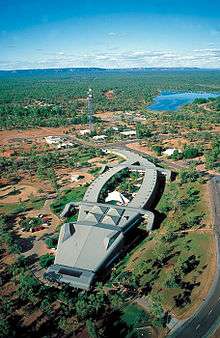
Jabiru is a town in the Northern Territory of Australia. It was originally built in 1982 as a closed town to house the community living at Jabiru East near the Ranger Uranium Mine eight kilometres away. Both the mine and the town are completely surrounded by Kakadu National Park. At the 2006 census, Jabiru had a population of 1,135.
| Jabiru Northern Territory | |||||||||
|---|---|---|---|---|---|---|---|---|---|
Jabiru | |||||||||
| Coordinates | 12°40′S 132°50′E | ||||||||
| Population | 1,081 (2016 census)[1] | ||||||||
| Postcode(s) | 0886 | ||||||||
| Elevation | 27 m (89 ft) | ||||||||
| Location | 256 km (159 mi) from Darwin | ||||||||
| LGA(s) | West Arnhem Region | ||||||||
| Territory electorate(s) | Arafura | ||||||||
| Federal Division(s) | Lingiari | ||||||||
| |||||||||
Overview
Jabiru Township is 13 square kilometres (5.0 sq mi) in size. The town is owned as freehold by the Director of National Parks, from which a head lease is held by the Jabiru Town Development Authority (JTDA). The JTDA subleases to the mining company, government agencies and private business. The head lease expires in 2021.
The JTDA has delegated local government responsibility to the Jabiru Town Council. The Northern Territory Government amalgamated Jabiru Town Council and the West Arnhem Shire (Region) in 2008. Additionally, Jabiru town services are administered by the West Arnhem Regional Council, whose council chambers are in the town plaza.
Apart from the Ranger mine, Jabiru's most notable industries are tourism (it is the commercial and accommodation hub of Kakadu National Park), and Aboriginal arts and culture. Jabiru features a small town plaza that includes government offices, magistrate's court and emergency services.
The Mirarr clan were recognised as the traditional title holders of Jabiru Township in November 2018.[2]
Population
According to the 2016 census of Population, there were 1,081 people in Jabiru.
- Aboriginal and Torres Strait Islander people made up 24.3% of the population.
- 68.6% of people were born in Australia.
- 64.9% of people only spoke English at home.
- The most common response for religion was No Religion, at 36.8%.[1]
Climate
Jabiru has a tropical monsoon season, typical of most of the Top End. Jabiru experiences heavy rain that often results in widespread flooding along the Arnhem Highway and Kakadu Highway. During 2006–07 Jabiru had its biggest wet season on record cutting both highways after almost 2 metres (6 ft 7 in) of rain fell over a 3-month period. The Arnhem Highway was cut off for several weeks as the West Alligator bridge was severely damaged. Temperatures can drop below 10 °C (50 °F) in the winter/dry season from May to August and peak at over 40 °C (104 °F) during the buildup season from September to November. Spectacular electrical storms are also frequent during this period, before the prolonged rains of the wet season arrive.
| Climate data for Jabiru | |||||||||||||
|---|---|---|---|---|---|---|---|---|---|---|---|---|---|
| Month | Jan | Feb | Mar | Apr | May | Jun | Jul | Aug | Sep | Oct | Nov | Dec | Year |
| Record high °C (°F) | 38.4 (101.1) |
37.7 (99.9) |
38.0 (100.4) |
38.0 (100.4) |
37.6 (99.7) |
36.0 (96.8) |
36.1 (97.0) |
38.0 (100.4) |
40.0 (104.0) |
41.6 (106.9) |
42.4 (108.3) |
39.6 (103.3) |
42.4 (108.3) |
| Average high °C (°F) | 33.6 (92.5) |
33.2 (91.8) |
33.5 (92.3) |
34.5 (94.1) |
33.5 (92.3) |
31.6 (88.9) |
31.9 (89.4) |
33.7 (92.7) |
36.2 (97.2) |
37.6 (99.7) |
36.9 (98.4) |
35.0 (95.0) |
34.3 (93.7) |
| Average low °C (°F) | 24.6 (76.3) |
24.5 (76.1) |
24.4 (75.9) |
23.5 (74.3) |
21.8 (71.2) |
19.1 (66.4) |
18.5 (65.3) |
19.1 (66.4) |
21.6 (70.9) |
23.9 (75.0) |
24.9 (76.8) |
24.9 (76.8) |
22.6 (72.7) |
| Record low °C (°F) | 20.5 (68.9) |
20.6 (69.1) |
20.4 (68.7) |
16.0 (60.8) |
13.9 (57.0) |
8.9 (48.0) |
8.8 (47.8) |
12.0 (53.6) |
12.0 (53.6) |
13.7 (56.7) |
19.0 (66.2) |
21.1 (70.0) |
8.8 (47.8) |
| Average rainfall mm (inches) | 356.2 (14.02) |
363.8 (14.32) |
320.3 (12.61) |
85.3 (3.36) |
12.6 (0.50) |
1.1 (0.04) |
3.0 (0.12) |
2.7 (0.11) |
7.0 (0.28) |
40.2 (1.58) |
143.8 (5.66) |
234.8 (9.24) |
1,570.8 (61.84) |
| Average rainy days | 21.3 | 20.7 | 20.1 | 7.7 | 2.4 | 0.3 | 0.3 | 0.2 | 0.7 | 3.5 | 11.4 | 16.6 | 105.2 |
| Source: [3] | |||||||||||||
Recreation
Recreational facilities include the Jabiru town lake (picnic areas and barbecues), freshwater fishing for barramundi (a local specialty), the Yellow Water cruise, day-trips to Ubirr Rock, Twin Falls and other natural features of Kakadu National Park, as well as a Sports and Social Club, an Olympic-size swimming pool (the only place guaranteed safe from crocodiles to swim), cricket ovals where cricket and Australian rules football are played. Magela Field in Jabiru is home to the Jabiru Bushratz RUFC, who are currently celebrating their 25th year in 2008. There is also a 9-hole golf course which is the only licensed premises for takeaway alcohol; however only members can buy takeaway alcohol there. Visitors can consume alcohol in opened containers on licensed premises.
References
- Australian Bureau of Statistics (27 June 2017). "Jabiru (State Suburb)". 2016 Census QuickStats. Retrieved 20 July 2017.

- Damjanovic, Dijana. "Jabiru native title claim victory for Mirarr traditional owners". Australian Broadcasting Corporation. Retrieved 9 November 2018.
- "Climate statistics for Australian locations". 16 May 2014.