Ivanhorod
Ivanhorod[2] or Ivangorod[3] (Ukrainian: Іванго́род; Russian: Ивангород; Polish: Iwangród) is a village located in the Khrystynivka Raion of the Cherkasy Oblast (province) in central Ukraine, some 151 kilometres (94 mi) from Kiev.[4][5]
Ivanhorod Івангород | |
|---|---|
Village | |
.JPG) Ivanhorod road sign | |
 Ivanhorod Location of Ivanhorod in Ukraine | |
| Coordinates: 48°48′10″N 29°48′09″E | |
| Country | |
| Province | |
| District | Khrystynivka Raion |
| Population (2001) | |
| • Total | 1,193 [1] |
| Time zone | UTC+2 (EET) |
| • Summer (DST) | UTC+3 (EEST) |
| Postal code | 20040 |
| Area code | +380 4745 |
History
The first traces of a settlement date back to prehistoric times, with archeological findings from the Cucuteni-Trypillian culture. In the Middle Ages Ivanhorod lay on the Chumak trade road from Kiev to Crimea. From the 13th century on, it was part of the Grand Duchy of Lithuania and subsequently, until 1791, the Polish–Lithuanian Commonwealth.[7] The village (from 1609 owned by the Kalinowski family) lay on the path of the Khmelnytsky Uprising.[8][9] After the Second Partition of Poland Iwanogród became part of the Russian Empire.
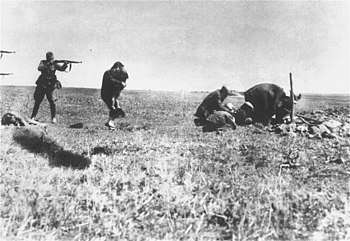
The Jewish community in Ivanhorod dates back to early 19th century. In 1897, the Jewish population was 442 people. During the Holocaust (on what is now Ukrainian territory), a mass murder was committed by the German Einsatzgruppe in the southern part of Ivanhorod (1942) with an unknown number of victims.[10]. It is known by the Ivanhorod Einsatzgruppen photograph.
Economy
As of 2013, Ivanhorod had 504 employed residents, with the main economic activity being agriculture. There is a school in the village, a library with 18,000 books, a medical clinic with 9 employees, pharmacy, a post office, a bank, and several large farms.[11]
Notes and references
- ВРУ (1994–2013). "Івангород, Черкаська область" (Internet Archive). Облікова картка. Верховна Рада України. Retrieved 13 July 2013.
- Lo-Tishkach (2013). "Ivanhorod, Uman-Vinnytsia road". European Jewish Cemeteries Initiative. Retrieved 13 July 2013.
- "Ivangorod, Ukraine – Satellite Images". Maplandia.com. 2005. Retrieved 13 July 2013.
- "Cherkasy Raion". Regions of Ukraine and their Structure (in Ukrainian). Verkhovna Rada of Ukraine. Retrieved 12 January 2012.
- Places in the world.com, World distance calculator. Starting point: Ivanhorod / Ukraine. End point: Kiev / Ukraine. Also: GPS. Retrieved December 8, 2014.
- Robert Fisk (19 November 2011). "Robert Fisk: Ukraine, 1942. What are we seeing?". The Independent.co.uk. Retrieved 19 July 2013.
- Склад Уманського козацького полку
- Ю. А. Мицик, О. Г. Бажан, В. С. Власов, Історія України, Києво-Могилянська академія, Київ 2008
- Diary of Albrecht Stanisław Radziwiłł (Google Books, p. 470). Also: Wojciech Jacek Długołęcki (1995), Batoh 1652, Warsaw: Bellona, pp. 25–26, 44, ISBN 83-11-08402-5
- "Ivanhorod". European Jewish Cemeteries Initiative. Archived from the original on 21 December 2014. Retrieved 28 September 2018.
- А. Г. Муха (January 25, 2013). "Archived copy" Бюджет Івангородської сільської ради (in Ukrainian). Христинівська районна державна адміністрація Черкаської області. Archived from the original on 9 December 2014. Retrieved 13 July 2013.CS1 maint: archived copy as title (link)
| Raions | |||||
|---|---|---|---|---|---|
| Hromadas | |||||
| Cities |
| ||||
| |||||