Isochrone map
An isochrone map (or chart/diagram) in geography and urban planning is a map showing areas related to isochrones between different points. An isochrone is defined as "a line drawn on a map connecting points at which something occurs or arrives at the same time".[1] Such a map is sometimes termed simply an isochrone (iso = equal, chrone = time). In hydrology and transportation planning isochrone maps are commonly used to depict areas of equal travel time. The term is also used in cardiology[2][3][4] as a tool to visually detect abnormalities using body surface distribution.[5]
History
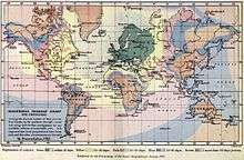
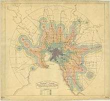
Isochrone maps have been used in transportation planning since 1887 or earlier.[6][7] Early examples of Isochrone maps include the Galton´s Isochronic Postal Charts and Isochronic Passage Charts of 1881 and 1882,[8] Bartholomew's Isochronic Distance Map and Chart first published 1889 [9] or earlier and Albrecht Penck's Isochronenkarte first published 1887.[10] Where as Galton and the Bartholomews published maps depicting the days or weeks it took to travel long distances, Albrecht further developed the idea to not only depict long distances and world travel but also smaller areas. Penck also created a series of maps that only depict the travel times of a certain transportation mode, for example Rail transport. Isochrone maps are commonly used in the UK in connection with development control.[11][12][13][14] Information technology in the 21st century has enabled them to be dynamically generated for use in websites, being used by house hunters wishing to evaluate residential areas.[15]
Usage
Hydrology
Isochrone and related maps are used to show the time taken for runoff water within a drainage basin to reach a lake, reservoir or outlet, assuming constant and uniform effective rainfall.[16][17][18][19] An early example of this method was demonstrated by Clark in 1945.[20]
Transport planning
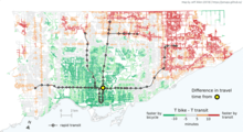
Isochrone maps in the context of transport planning are essentially maps of accessibility where travel time is used as the cost metric. Isochrone maps can be created for different modes of transportation,[21] e.g. foot, bicycle, motor vehicle. Put simply, the output of an isochrone map for transport will show how far (in distance) is reachable from a start point, including the parameter of time. An example of the output can be found using this interactive Mapbox example, where you can see how far can be traveled in a specific amount of time.
Such maps for private motor transport were widely used in a 1972 study into airport accessibility in Hampshire, South East England.[22] At that time, their use was disadvantaged by being time consuming to create.[22]
The term isodapane map is used to refer to a map were the contour represent transportation cost instead of transportation time.[23]
Isochrone maps can be generated using the Google Maps API[24] or TravelTime API[25] and this can be done from arbitrary starting points.[26][27] The creation of journey time isochrones to airports in Finland has been explained using the GIS software QGIS and pgRouting (an extension of PostGIS).[28] Isochrones for transit travel times can be computed using the routing engine OpenTripPlanner.[29]
General public
Journey time websites have been built using mapping technologies and open data.[30][31] Examples of such sites are PedCatch, instaGIS,[32] TravelTime platform by iGeolise,[33][34] Mapumental[15] and Mapnificent.[30][35][36] Such sites can be used by house hunters wishing to evaluate residential areas.[15] An isochrone map of the London Underground network was made available in 2007.[37] Iso4App is an isochrone map service (car, bike and pedestrian) available on Europe, Russian Federation, Ukraine, China, North America, Latin America, Australia-Oceania, South Africa; in addition iso4app implements isochrones on public transport. Demo is available at Tolosa (France). A time-based travel map that went viral was the Isochronic World Map, produced using data from Rome2rio's routing engine for plane, train, bus, ferry and automobile. It compared travel times from London in 2016 versus 1914.[38]
References
- Desai, Kiran (17 October 2008). "Isochrones: Analysis of Local Geographic Markets" (PDF). Mayer Brown. Retrieved 2018-05-31.
- "MFS ECG Potential Map (40ms)". Springer Science+Business Media. Retrieved March 21, 2012.
- Rosenbaum, David S.; Jalife, José (2001). Optical mapping of cardiac excitation and arrhythmias. Wiley-Blackwell. p. 251. ISBN 0879934816.
- Ramanathan, Charulatha; Jia, Ping; Ghanem, Raja; Ryu, Kyungmoo; Rudy, Yoram (April 2006). "Activation and repolarization of the normal human heart under complete physiological conditions". PNAS. 103 (16): 6309–6314. doi:10.1073/pnas.0601533103. PMC 1458874. PMID 16606830.
- Miyashita, T; Okano, Y (January 1995). "Isochrone map, its implication and clinical usefulness". Nihon Rinsho: Japanese Journal of Clinical Medicine. 53 (1): 48–55. PMID 7897854.
- "Mapping Manchester project". October 2013. Retrieved May 5, 2014.
- "Dissertation of Johannes Riedel". 1911.
- Galton, Francis (1881). "On the Construction of Isochronic Passage Charts". Proceedings of the Royal Geographical Society. Royal Geographical Society: 657.
- Bartholomew (1889). Atlas of Commercial Geography. Edinburgh: John Bartholomew and Son. p. S. VI, Map 13 a.
- Penck, Albrecht (1887). "Isochronenkarte der österreichisch-ungarischen Monarchie". Deutsche Rundschau für Geographie und Statistik: 337.
- "Planning for Town Centres; Practice guidance on need, impact and the sequential approach" (PDF). Department for Communities and Local Government. December 2009. Retrieved March 26, 2012.
- "Transport Assessment; Guidelines for Development Proposals in Northern Ireland" (PDF). Department for Regional Development. November 9, 2006. Retrieved March 26, 2012.
- "Technical Guidance on Accessibility Planning in Local Transport Plans" (PDF). Local Transport Planning Network. Archived from the original (PDF) on November 20, 2007. Retrieved March 26, 2012.
- Barker, Kate (December 2006). "Barker Review of Land Use Planning" (PDF). Retrieved March 26, 2012.
- "House-hunting goes hi-tech". The Independent. November 25, 2009. Retrieved March 22, 2012.
- Bell, V. A.; Moore, R. J. (1998). "A grid-based distributed flood forecasting model for use with weather radar data: Part 1. Formulation" (PDF). Hydrology and Earth System Sciences. Copernicus Publications. 2 (2/3): 265–281. doi:10.5194/hess-2-265-1998.
- Subramanya, K (2008). Engineering Hydrology. Tata McGraw-Hill. p. 298. ISBN 978-0070648555.
- "EN 0705 isochrone map". UNESCO. Archived from the original on November 22, 2012. Retrieved March 21, 2012.
- "Isochrone map". Webster's Online Dictionary. Archived from the original on January 13, 2013. Retrieved March 21, 2012.
- "Unit Hydrograph (UHG) Technical Manual". National Oceanic and Atmospheric Administration. Retrieved March 21, 2012.
- Gamper Johann; Böhlen, Michael; Cometti, Willi; Innerebner, Markus (2011). "Defining isochrones in multimodal spatial networks". Proceedings of the 20th ACM international conference on Information and knowledge management. CIKM. Glasgow. doi:10.1145/2063576.2063972. ISBN 9781450307178. Retrieved March 21, 2012.
- Armstrong, H. W. (September 1972). "A Network Analysis of Airport Accessibility in South Hampshire" (PDF). Journal of Transport Economics and Policy. 6 (3): 294–307. ISSN 0022-5258.
- Barthwal, R. R. (2007). Industrial Economics: An Introductory Text Book. New Age International. ISBN 9788122412789.
- "Generate an isochrone map using Google Maps Api". DZone. January 18, 2010. Retrieved March 21, 2012.
- Contributor, G. I. S. (2016-07-09). "Using the TravelTime Search API to Generate an Isochrone". GIS Lounge. Retrieved 2020-06-22.
- Arthur, Charles (May 28, 2006). "Travel maps of Britain ... measured by time, not distance". The Guardian. Retrieved March 21, 2012.
- Street, Nicholas (June 14, 2006). "TimeContours: Using isochrone visualisation" (PDF). Imperial College London. Retrieved March 21, 2012.
- Graser, Anita (February 12, 2011). "Drive Time Isochrones – An Example Using Finnish Airports". Retrieved March 22, 2012.
- "Intermediate Tutorial - OpenTripPlanner". docs.opentripplanner.org. Retrieved 2018-11-08.
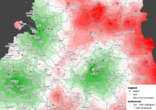
- "Looking for the best commuter route to Salford Quays? Stefan in Berlin can help with that". Manchester Evening News. June 7, 2011. Retrieved March 22, 2012.
- Hartley, Sarah (February 24, 2011). "Greater Manchester datastore launched". The Guardian. Retrieved March 22, 2012.
- "instaGIS: Discovering Isochrones". instaGIS. Retrieved 1 September 2014.
- Davis, By Hazel. "Time lords at iGeolise make minutes out of miles". Telegraph.co.uk. Retrieved 2016-06-15.
- Arthur, Charles (2012-11-02). "iGeolise lets you measure distance by time rather than as the crow flies". the Guardian. Retrieved 2016-06-15.
- N.B. (Jun 5, 2011). "A time-based transit map". The Economist. London. Retrieved March 22, 2012.
- O'Brien, Terrence (August 5, 2011). "Mapnificent visualizes public transportation travel time, is more exciting than it sounds". Engadget. Retrieved March 22, 2012.
- DrAlanRae (July 25, 2007). "Getting about – Isochrone map of London Underground". howtodobusiness.com. Archived from the original on April 17, 2012. Retrieved March 21, 2012.
- "A Map Goes Unexpectedly Viral, With Help From Reddit & Gizmodo – Rome2rio". www.rome2rio.com. Retrieved 2016-12-19.
External links
| Wikimedia Commons has media related to Isochrone maps. |
Free web app : isochrone calculator www.owlapps.net/application-geomarketing