Interstate 95 in Virginia
Interstate 95 (I-95) runs 179 miles (288 km) within the Commonwealth of Virginia between its borders with Maryland and North Carolina. I-95 is concurrent with I-64 for 3 miles (4.8 km) in Richmond, and meets the northern terminus of I-85 in Petersburg. Although I-95 was originally planned as a highway through Washington, D.C. (following the route of what is now I-395), it was rerouted along the eastern portion of the Capital Beltway. From Petersburg to Richmond, I-95 was most of the Richmond-Petersburg Turnpike (the south end of the toll road was on I-85.)
| ||||
|---|---|---|---|---|
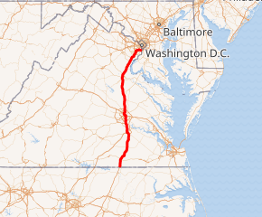
I-95 highlighted in red | ||||
| Route information | ||||
| Maintained by VDOT | ||||
| Length | 178.73 mi[1] (287.64 km) | |||
| Existed | 1957–present | |||
| Major junctions | ||||
| South end | ||||
| ||||
| North end | ||||
| Location | ||||
| Counties | Greensville, City of Emporia, Sussex, Prince George, City of Petersburg, City of Colonial Heights, Chesterfield, City of Richmond, Henrico, Hanover, Caroline, Spotsylania, City of Fredericksburg, Stafford, Prince William, Fairfax, City of Alexandria | |||
| Highway system | ||||
| ||||

It enters the Capital Beltway at the Springfield Interchange, also known as the Mixing Bowl. I-95 continues over the Woodrow Wilson Bridge into Washington, D.C. (for 0.11 miles on the bridge), and then into Maryland on the Beltway.
The route between Fredericksburg, Virginia, and Springfield, Virginia, is consistently one of the most congested routes of highway in the United States, particularly during holidays and rush hours. The causes for this congestion are lack of alternative routes, fewer lanes than needed, and the spread-out suburbs of the Washington D.C. area.[2]
Route description
North Carolina to Petersburg
Interstate 95 continues the pattern of being a four-lane highway from North Carolina. The welcome center forbids trucks, but truck stops at the first two interchanges provides a substitute place for truckers to stay before reaching Emporia.[3][4] North of here, I-95 and US 301 are often intertwined with each other as they encounter interchanges with Virginia Secondary State Routes. In the Owens-Stony Creek area in Sussex County, the road not only runs parallel to US 301 but shares bridges with I-95, many of which have access to Route 301 from connecting roads. This pattern ends at Exit 33 at the corner of a fairly popular truck stop and travel center. Crossing the Sussex-Prince George County Line, the first site along I-95 is another rest area that also serves as the Petersburg Area Tourist Information Center. The road makes a slight northeast turn between Carson and Templeton, then turns straight north again before approaching the south end of Interstate 295 just before crossing the southern border of the City of Petersburg at Exit 47. A series of frontage roads connect the interchanges with US 460, US 301 and the northern terminus of Interstate 85. Immediately after the interchange with Interstate 85, remnants of the former toll booths for the Richmond–Petersburg Turnpike can be found.[5]
Petersburg to Richmond
_between_Exit_54_(Virginia_State_Route_144-Temple_Avenue)_and_Exit_53_(Southpark_Boulevard)_in_Colonial_Heights%2C_Virginia.jpg)
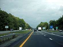
North of Petersburg, I-95 crosses the Appomattox River and enters the City of Colonial Heights and then Chesterfield County. Pocahontas Parkway and an extraordinarily high Vietnam Veterans Memorial Bridge over I-95 and the James River just south of the Richmond City Limits. A CSX railroad line runs parallel to the northbound lane in the vicinity of the Port of Richmond, and the Commerce Road Industrial Area, a region that includes a Philip Morris office and an old bridge manufacturing plant.[6] As I-95 itself crosses the James River, Main Street Station can be seen on the north bank, and the road winds around the station itself.[7] The first interchange after it crosses the James River is the tolled State Route 195 and from there the road winds towards the multiplex with Interstate 64. I-64/95 curves to the northwest to cross under US 1/301, only to turn back north briefly, and curve northwest again, as it approaches VA 161. This pattern ends when I-64 turns west at the same interchange as the northern terminus of I-195. From here I-95 curves back to the northeast and has two interchanges with US 1, and later US 301 separately, the latter of which has separate carriageways on both side of I-95. Another interchange with Interstate 295 exists in Glen Allen. However, I-295 does not terminate there, and the south-to-eastbound and west-to-northbound off-ramps between the two can be accessed in the medians of both roads.
Central Virginia to Washington, D.C.
_in_Southern_Gateway%2C_Stafford_County%2C_Virginia.jpg)
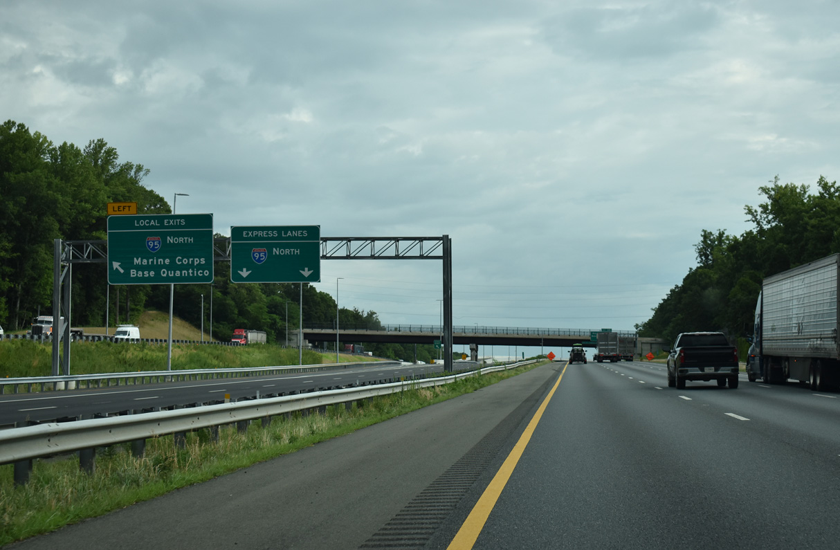
Throughout much of central Virginia, I-95 climbs a series of hills, and contains wide tree-lined medians. Near mile marker 100 in Doswell, signs for the Kings Dominion amusement park are blended in with standard destination signs. US 17 overlaps I-95 from Massaponax at exit 126 to Falmouth at exit 133 as the highway passes west of Fredericksburg. The wide tree-line divider resumes north of here. At Exit 143 in Aquia, the northbound off and on ramps connect directly to US 1, even though the interchange is specifically for SR 610.[8][9] Crossing over the Chopawamsic Creek takes I-95 through the Quantico Marine Base, which includes restrictive interchanges.[10] Northbound, the bi-directional HOT lane begins in Stafford, and runs through the center of I-95 through most of the rest of its journey toward D.C.
_on_the_edge_of_Potomac_Mills_and_Marumsco_in_Prince_William_County%2C_Virginia.jpg)
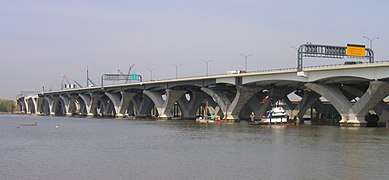
Further north in Prince William County, there are four rest areas; two for trucks in Dumfries, and two for cars in Dale City. The truck rest areas, with weigh stations, are near exit 152. The car rest areas have uniquely positioned entrance and exit ramps. The southbound car rest area, near exit 156, is accessible only from the southbound collective-distributor road. In Lorton, a scissor interchange exists with US 1, and shortly after this Lorton Auto Train Station is located near exit 163. Due to public opposition of efforts to build I-95 through Washington D.C. and College Park, Maryland, I-95 is diverted onto a multiplex with Interstate 495 at the Springfield Interchange. I-95/495 continue east through Franconia, over the WMATA Blue Line and Rose Hill. At Huntington, I-95/495 run under the WMATA Yellow Line, and through Alexandria before crossing the Woodrow Wilson Bridge briefly into D.C., and then into Maryland.
Auxiliary routes
Current
_as_it_crosses_the_Potomac_River_on_the_Woodrow_Wilson_Bridge_in_Alexandria%2C_Virginia.jpg)
- Interstate 195 is a short spur from north of downtown Richmond south into downtown.
- Interstate 295 is a bypass to the east of Richmond, from I-95 south of Petersburg, across Interstate 64 east of Richmond and I-95 north of Richmond to I-64 west of Richmond.
- Interstate 395 is a branch from Springfield north into downtown Washington, D.C. It was part of I-95 until 1977.
- Interstate 495 is the Capital Beltway, a full loop around Washington, D.C. Since 1977, I-95 has run along its east half.
Former
- Business Loop 95 was a former business loop of Interstate 95 in and out of Emporia, Virginia between Exits 8 and 12, running mostly along US 301.
- Interstate 595 was a planned branch from I-395 south to Washington National Airport along U.S. Route 1.
- Interstate 795 was a planned number for present I-95 from I-295 south of Petersburg to Interstate 85 in downtown Petersburg; I-95 would have bypassed Petersburg and Richmond to the east on I-295. The renumbering was never done because tolls were removed from the Richmond-Petersburg Turnpike section of I-95.[11]
- State Route 895 is the Pocahontas Parkway, a connection from I-95 south of Richmond east to I-295. It was not numbered as an Interstate because the project opened as a toll road using federal funds, thus disqualifying it from Interstate status.
HOV facilities
_just_north_of_Dumfries_in_Prince_William_County%2C_Virginia.jpg)
Interstate 95 extends the twin-lane barrier-separated HOV lanes that begin on I-395 at the 14th Street Bridge in Washington. These lanes have been extended south several times, most recently to just north of Stafford right before the Garrisonville Road exit.
As part of the Quantico Creek bridge rebuilding project, a three-lane, 300-foot-long (91 m) bridge was constructed in the median just south of the old southern HOV terminus for use when the HOV facilities were extended. It was previously used as a detour bridge and retained its lane striping from such use.
In December 2014, this bridge became part of the Southern HOV/HOT lane extension project that now runs to just north of Garrisonville Rd. (exit 143) in Stafford.[12][13]
The new I-95 HOV/HOT lanes project created approximately 29 miles (47 km) of HOV/HOT lanes on I-95 from Garrisonville Rd. in Stafford County to the vicinity of Edsall Road on I-395 in Fairfax County.[14]
In July 2016, VDOT began construction of an additional one-mile (1.6 km) extension of the HOV/HOT lanes on I-95 south of Garrisonville Rd. in Stafford County. This addition opened in November 2017.[15]
Welcome centers, rest areas and weigh stations
- Northbound Virginia Welcome Center: Milepost 1, north of VA State Line
- Northbound Petersburg Welcome Center: Milepost 35 between Exits 33 and 37
- Carson Weigh Stations: Milepost 40 between Exits 37 and 41
- Ladysmith Rest Areas: Milepost 108 between Exits 104 and 110
- Southbound Fredericksburg Rest Area: Milepost 132 between Exits 130 and 133
- Dumfries Rest Area and Weigh Stations: Milepost 153 between Exits 152 and 156
- Dale City Rest Areas: Milepost 155 between Exits 152 and 156
Exit list
| County | Location | mi[1] | km | Exit | Destinations | Notes |
|---|---|---|---|---|---|---|
| Greensville | | 0.00 | 0.00 | Continuation into North Carolina | ||
| Skippers | 4.13 | 6.65 | 4 | |||
| | 8.25 | 13.28 | 8 | |||
| City of Emporia | 11.00 | 17.70 | 11 | Signed as exits 11A (west) and 11B (east) | ||
| Greensville | | 12.99 | 20.91 | 12 | Northbound exit only | |
| | 13.51 | 21.74 | 13 | |||
| Sussex | | 17.30 | 27.84 | 17 | ||
| | 20.25 | 32.59 | 20 | Former SR 137; to SR 139 | ||
| Owens | 24.29 | 39.09 | 24 | |||
| Stony Creek | 30.92 | 49.76 | 31 | |||
| | 33.37 | 53.70 | 33 | |||
| Prince George | Carson | 37.15 | 59.79 | 37 | Former SR 141 west | |
| Templeton | 40.88 | 65.79 | 41 | |||
| Kingwood | 45.42 | 73.10 | 45 | |||
| | 46.53 | 74.88 | 46 | I-295 to 95 north exit 1 | ||
| City of Petersburg | 47.74 | 76.83 | 47 | |||
| 48.89 | 78.68 | 48 | Signed as exits 48A (east) and 48B (west); south end of US 460 overlap; serves Southside Regional Medical Center | |||
| 50.61– 51.06 | 81.45– 82.17 | 50 | Northbound signed as "US 460 east to SR 109/US 301/Wythe St./Washington St."; southbound signed as "US 301/US 460 Bus." only; signed as exits 50A (US 460), 50B-C (US 301), and 50D (Wythe St./Washington St.) northbound | |||
| 51.71 | 83.22 | 51 | Northern end of US 460 concurrency; Northern terminus of I-85 | |||
| 52.14 | 83.91 | 52 | Bank Street | Northbound exit only | ||
| 52.15 | 83.93 | Washington Street / Wythe Street – Petersburg National Battlefield | ||||
| Appomattox River | 52.79 | 84.96 | Appomattox River Bridge | |||
| City of Colonial Heights | 53.00 | 85.30 | 53 | Southpark Boulevard | ||
| 53.98 | 86.87 | 54 | ||||
| Chesterfield | | 57.91 | 93.20 | 58 | Signed as exits 58A (west) and 58B (east) southbound | |
| Chester | 60.81 | 97.86 | 61 | Signed as exits 61A (east) and 61B (west) | ||
| 62.62 | 100.78 | 62 | ||||
| | 64.66 | 104.06 | 64 | |||
| Bensley | 67.43 | 108.52 | 67 | Signed as exits 67A (east) and 67B (north) northbound; no access from I-95 south to SR 895 east | ||
| City of Richmond | 69.35 | 111.61 | 69 | |||
| 73.16 | 117.74 | 73 | Maury Street / Commerce Road | |||
| 73.61 | 118.46 | James River Bridge | ||||
| 74.01 | 119.11 | 74A | ||||
| 74.30 | 119.57 | 74B | Franklin Street | Southbound exit only | ||
| 74.63 | 120.11 | 74C | No access from I-95 south to US 250 east | |||
| 75.55 | 121.59 | 75 | Southern end of I-64 concurrency; I-64 exit 190 | |||
| 75.85 | 122.07 | 76A | Chamberlayne Avenue (US 1 / US 301 north) | Northbound exit and southbound entrance | ||
| 76.09 | 122.45 | 76B | No northbound exit | |||
| 78.06 | 125.63 | 78 | Boulevard (SR 161) | |||
| 78.84 | 126.88 | 79 | Northern end of I-64 concurrency; I-64 exit 187 | |||
| 79.91 | 128.60 | 80 | Northbound exit and southbound entrance | |||
| Henrico | Brook Hill | 80.82 | 130.07 | 81 | Northbound exit and southbound entrance | |
| | 81.12 | 130.55 | 82 | Former northern terminus of Richmond–Petersburg Turnpike | ||
| Yellow Tavern | 82.94 | 133.48 | 83 | Signed as exits 83A (east) and 83B (west) | ||
| | 84.41 | 135.84 | 84 | Signed as exits 84A (south) and 84B (north); I-295 exit 43; Rocky Mount, NC signed northbound; Williamsburg and Virginia Beach signed southbound | ||
| Hanover | Ashland | 87.30 | 140.50 | 86 | Signed as exits 86A (east) and 86B (west) | |
| Lewistown | 89.09 | 143.38 | 89 | |||
| Ashland | 91.74 | 147.64 | 92 | Signed as exits 92A (east) and 92B (west) northbound | ||
| | 97.75 | 157.31 | 98 | Southbound Exit 98 splits to separate ramp to Kings Dominion | ||
| Caroline | Carmel Church | 104.18 | 167.66 | 104 | ||
| Ladysmith | 110.30 | 177.51 | 110 | To former SR 229 west | ||
| Spotsylvania | Thornburg | 118.26 | 190.32 | 118 | ||
| | 125.84 | 202.52 | 126 | Southern end of US 17 concurrency; signed as exits 126A (north) and 126B (south) northbound | ||
| City of Fredericksburg | 129.54 | 208.47 | 130 | Signed as exits 130A (east) and 130B (west) | ||
| Rappahannock River | 131.83 | 212.16 | Rappahannock Falls Bridge | |||
| Stafford | | 133.08 | 214.17 | 133 | Northern end of US 17 concurrency; signed as exits 133A (south) and 133B (north) southbound | |
| | South end of proposed I-95 Express lanes extension for construction to start in 2019 | |||||
| | 135.61 | 218.24 | 136 | Exit opened December 22, 2005 | ||
| | 139.83 | 225.03 | 140 | To former SR 212 east | ||
| | 141.00 | 226.92 | Current south end of I-95 Express lanes | |||
| Aquia | 142.73 | 229.70 | 143A | Signed as US 1 northbound and SR 610 southbound; former SR 213 | ||
| 143B | Former SR 213 | |||||
| | 145.30 | 233.84 | Northbound exit and southbound entrance | |||
| Prince William | | 147.65 | 237.62 | 148 | Marine Corps Base Quantico | |
| Triangle | 149.97 | 241.35 | 150 | Signed as exits 150A (east) and 150B (west) southbound; commercial vehicles to Marine Corps Base Quantico must use exit 148 | ||
| | 151.00 | 243.01 | Northbound exit and southbound entrance | |||
| Dumfries | 152.36 | 245.20 | 152 | Signed as exits 152A (south) and 152B (north) | ||
| Dale City | 155.91 | 250.91 | 156 | Since 2012, signed as exits 156A (east) and 156B (west); northbound entrance includes direct entrance ramp from Opitz Boulevard, and direct exit ramp to I-95 Express lanes | ||
| | 157.00 | 252.67 | No direct northbound exit | |||
| | 158.13 | 254.49 | 158 | Signed as exits 158A (east) and 158B (west) | ||
| | 158.13 | 254.49 | — | Southbound exit and northbound entrance for I-95 Express lanes; exit includes direct exit ramp to Horner Road Commuter Parking Lot | ||
| Woodbridge | 160.05 | 257.58 | 160 | Signed as exits 160A (south) and 160B (north) northbound; no access from I-95 south to SR 123 south | ||
| | 160.05 | 257.58 | — | Southbound exit and northbound entrance for I-95 Express lanes | ||
| Fairfax | Lorton | 161.17 | 259.38 | 161 | Northbound exit and southbound entrance | |
| Southbound exit and northbound entrance for I-95 Express lanes | ||||||
| Southbound left exit and northbound entrance | ||||||
| 163.66 | 263.39 | 163 | ||||
| Newington | 165.56 | 266.44 | Northbound exit only | |||
| 166.00 | 267.15 | Alban Road / Boudinot Drive | Southbound entrance only for I-95 Express lanes | |||
| 166.80 | 268.44 | 166 | Signed as exits 166A (south) and 166B (north); Heller Rd. not signed northbound; Backlick Rd./Fullerton Rd. not signed southbound | |||
| 167.00 | 268.76 | Southbound exit and northbound entrance | ||||
| 167.81 | 270.06 | 167 | Southbound exit only | |||
| Springfield | 169.05 | 272.06 | 169A-B | No southbound exit; signed as exits 169A (east) and 169B (west) | ||
| — | I-95 Express lane interchange | |||||
| Northbound exit and southbound entrance | ||||||
| — | Southbound exit and northbound entrance for I-95 Express lanes | |||||
| 169.05– 171.01 | 272.06– 275.21 | 170A-B | Part of Springfield Interchange; northbound exit and southbound entrance; signed as exits 170A (I-395) and 170B (I-495); I-395 exits 1A-B | |||
| — | I-95 Express lane interchange; part of Springfield Interchange | |||||
| — | I-95 Express lane interchange; part of Springfield Interchange | |||||
| Part of Springfield Interchange; north end of I-95 Express lanes | ||||||
| 170A | Southern end of I-495 concurrency; part of Springfield Interchange; southbound exit and northbound entrance | |||||
| Franconia | 171.97 | 276.76 | 173 | Formerly signed as exit 3 (following old Capital Beltway numbering) | ||
| | 173.51 | 279.24 | 174 | Eisenhower Avenue Connector – Alexandria | ||
| | 174.31 | 280.52 | — | South end of Thru Lanes | ||
| Huntington | 175.06 | 281.73 | 176A-B | Signed as exits 176A (south) and 176B (north); formerly signed as exit 2 (following old Capital Beltway numbering) | ||
| 176.27 | 283.68 | — | Eisenhower Avenue | Southbound exit and northbound entrance for Thru Lanes only | ||
| City of Alexandria | 176.57 | 284.16 | 177A-B | Signed as exits 177A (south) and 177B (north); formerly signed as exit 1 (following old Capital Beltway numbering); entrances include direct entrance ramps onto Thru Lanes; no access to northbound Thru Lanes from US 1 north | ||
| 177C | Mount Vernon | Southbound exit only | ||||
| Potomac River | 177.64 | 285.88 | Woodrow Wilson Bridge VA–DC and DC–MD lines | |||
| Continuation beyond Virginia | ||||||
1.000 mi = 1.609 km; 1.000 km = 0.621 mi
| ||||||
Usage
In 2010, volume at Newington, northbound, from 6-9 am, is about 8,800 vehicles in the two HOV lanes, and 18,300 vehicles in the three lanes with no restriction.[16]
References
- Staff (2014). "2014 Traffic Data". Virginia Department of Transportation. Retrieved 2015-08-31.
- Greensville County and City of Emporia (PDF)
- Sussex County (PDF)
- Prince George County and City of Hopewell (PDF)
- Dinwiddie County and City of Petersburg (PDF)
- Chesterfield County, City of Richmond, and City of Colonial Heights (PDF)
- Henrico County (PDF)
- Hanover County (PDF)
- Caroline County (PDF)
- Spotsylvania County and City of Fredericksburg (PDF)
- Stafford County (PDF)
- Prince William County, City of Manassas, and City of Manassas Park (PDF)
- Fairfax County, City of Fairfax, and City of Falls Church (PDF)
- Arlington County and City of Alexandria (PDF)
- Thomson, Robert (May 8, 2012). "Southbound I-95: Drivers warn of heavy traffic, offer tips to avoid the worst of it". WashingtonPost.com. Retrieved January 8, 2018.
- "#317 Skippers, VA". myloves317.com.
- Services, Environmental Management. "Simmons Travel Centers Offer Food, Lounges, CAT Scales". www.parkeroilcompany.com.
- "NETRonline: Historic Aerials - Viewer". historicaerials.com.
- "Creative Visual Design – Aerial Photography & Videography based in Richmond, VA with Keywords: landmarks".
- DanTD (June 8, 2010). Richmond Main Street Station from I-95 in Virginia (photograph). Retrieved November 1, 2017.
- Northbound I-95 image at Exits 143 A-B (AARoads.com)
- Aerial view of Exit 143 interchange on Interstate 95 (Google Maps)
- Sign requiring commercial vehicles to Quantico Marine Base to use Exit 148 (AARoads.com)
- "Interstate 95 (AARoads.com; Interstate Guide)". Retrieved 4 October 2014.
- The orphaned bridge over Quantico Creek is located at 38.568175°N 77.335274°W
- "I-95 Quantico Creek bridge reconstruction project from VDOT". Archived from the original on 2007-09-26. Retrieved 2007-09-02.
- "VIRGINIA ADVANCES NEW I-95 HOV/HOT LANES PROJECT AND NEW RAMP TO SEMINARY ROAD AT MARK CENTER". Virginiadot.org. Retrieved 2011-09-19.
- "I-95 Express Lanes Southern Extension". www.virginiadot.org.
- Thomson, Robert (18 April 2010). "Dr. Gridlock column:Opening HOV lanes to all after crash not a quick and easy job". Washington, DC: Washington Post. pp. C2.
External links
| Wikimedia Commons has media related to Interstate 95 in Virginia. |
- Exitlists.com (I-95)
- I-95 Rest Areas in Virginia (I-95 Exit Information Guide)
- Truckers Directory - State Weigh Stations in Virginia
| Previous state: North Carolina |
Virginia | Next state: District of Columbia |
| ||