Interstate 277 (North Carolina)
Interstate 277 (I-277) is a auxiliary Interstate Highway in the U.S. state of North Carolina. It serves as a 4.41 mi (7.10 km) partial loop around Charlotte center city.
| ||||
|---|---|---|---|---|
| Brookshire Freeway John Belk Freeway | ||||
%26groups%3D_ff0b0dfe2e42d5c366a66003a08e7e6ca59e06d3.svg)
I-277 highlighted in red | ||||
| Route information | ||||
| Auxiliary route of I-77 | ||||
| Maintained by NCDOT | ||||
| Length | 4.41 mi[1][2][3] (7.10 km) | |||
| Existed | 1981–present | |||
| Major junctions | ||||
| South end | ||||
| North end | ||||
| Location | ||||
| Counties | Mecklenburg | |||
| Highway system | ||||
| ||||

Route description
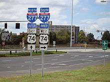
I-277 is a four to eight-lane downtown beltway that surrounds Charlotte center city. Starting at exit 9 on I-77/US 21, it goes northeast, in concurrency with US 74, to Independence Freeway; from there it goes northwest, in concurrency with NC 16, back to I-77/US 21 (exit 11). I-277 is signed both north–south and with inner/outer directions.
I-277 is one of three ring roads serving the Charlotte area, the other two being Interstate 485 and Charlotte Route 4.
Alternate names
Though the highway is commonly known as "Interstate 277" or "I-277" throughout the state, the highway does have other known names it uses locally in areas.
- Brookshire Freeway – official North Carolina name of Interstate 277/NC 16 from Independence Freeway to I-77/US 21, named after former Charlotte Mayor Stanford Raynold "Stan" Brookshire (approved on September 8, 1975).[4]
- John Belk Freeway – official North Carolina name of Interstate 277/US 74 from I-77/US 21 to Independence Freeway, named after former Charlotte Mayor and businessman John M. Belk (approved on September 11, 1981).[4]
History
The two freeway names were taken from former mayors of Charlotte, Stan Brookshire (1961–69) and John Belk (1969–77). The Brookshire was originally the Northwest Freeway (this name change took place in 1975), and the Belk is the newer stretch that was opened to traffic in two phases—the first in 1981 and the second in 1988. In addition, the Belk was the first section to be signed as I-277; the designation did not extend onto the Brookshire until 1987. John Belk's family is also the same one who founded the Belk department store chain. The two mayors are also the subjects of Brookshire & Belk: Businessmen in City Hall, a book written by Alex Coffin that highlights their accomplishments for Charlotte over the years. Most local residents, as well as traffic reports airing on local radio and television stations, use the names "Belk" and "Brookshire" when referring to I-277 rather than the highway number.[5]
I-277, as well as parts of I-77 and I-85, was notorious for being dark at night because its streetlights were not in working order.[6] There were many different plans to replace the streetlights on this freeway, most of which had been in place since the early 1970s. A proposal to replace the streetlights with solar power was denied in 2007 because these lights weren't deemed bright enough (however, two solar-powered streetlights were operating on I-77 at the LaSalle Street exit until November 2007, and mounted on the same poles as their older counterparts but halfway down), so new electric-powered high-pressure sodium streetlights would have to be installed instead. A relighting project finally got underway in October 2008, which involved setting up new light towers at the Independence Boulevard and I-77 exits, as well as installating new lights and removing the old nonworking ones on the Brookshire portion of the interstate. This project was completed by the spring of 2009.[7] A similar project was also done for the Belk portion of the interstate. In addition, highly reflective signs were also installed on the entire loop to give drivers better vision at night without the aid of additional lighting. In 2018, new LED high-masts were installed at the southern I-77, South Boulevard and Independence Boulevard interchanges, as part of a statewide conversion project; as of 2019, the HPS lights on both I-277 and the Independence Expressway approach have been replaced with LED.[8]
In April 2010, the new color-coded attraction guide signs were added along I-77 & I-277 to help visitors reach popular destinations, including: Bank of America Stadium, The Spectrum Center, and the NASCAR Hall of Fame among others.
In 2018, work began on I-277's northern interchange with I-77, as part of a toll lane project on the latter highway that would connect Uptown with the northern suburbs of Huntersville, Cornelius, Davidson and Mooresville. Two new flyover ramps were constructed, and the existing flyover from the end of I-277 to southbound I-77 was rebuilt higher to accommodate the new ramps.
On September 1, 2019, the inner lanes of I-277 and their associated ramps were closed to vehicles for the first time, as part of a route for the city's inaugural Around the Crown 10K marathon that took place entirely in Uptown. The runners raced counterclockwise on the interstate between the Hill Street onramp to the Belk and the 11th Street offramp from the Brookshire.[9]
In November 2019, I-277 was connected to the I-77 Express Lanes as the opening of the southern part of the I-77 Express lanes,
Exit list
The entire route is in Charlotte, Mecklenburg County.
| mi[3] | km | Exit | Destinations | Notes | |
|---|---|---|---|---|---|
| 0.0 | 0.0 | — | Continuation as US 74 | ||
| 1A | Southbound exit and northbound entrance | ||||
| 0.1 | 0.16 | 1B | |||
| 1C | |||||
| 0.6 | 0.97 | 1D | Carson Boulevard | Northbound exit and entrance only | |
| 1.0 | 1.6 | 1E | Northbound: College Street, South Boulevard, Caldwell Street Southbound: Stonewall Street, Kenilworth Avenue, South Boulevard, Caldwell Street | ||
| 1.9 | 3.1 | 2A | South end of NC 16 overlap | ||
| 2.7 | 4.3 | 2B | East end of US 74 overlap; semi-directional T interchange | ||
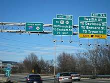
| 3.2 | 5.1 | 3A | Northbound: Twelfth Street, Davidson Street, Brevard Street, Tryon Street Southbound: Brevard Street, Davidson Street, McDowell Street | ||
| 3.6 | 5.8 | 3B | Northbound: Southbound: Eleventh Street, Church Street, Tryon Street | To AvidxChange Music Factory | |
| 3.8 | 6.1 | 4 | Southbound exit and northbound entrance | ||
| 4.4 | 7.1 | 5A | |||
| 5B | Northbound exit and southbound entrance | ||||
| 5C | Northbound left exit | ||||
| — | Continuation as NC 16 | ||||
| 1.000 mi = 1.609 km; 1.000 km = 0.621 mi | |||||
See also
References
- "FHWA Route Log and Finder List - Interstate Highway System - National Highway System - Planning - FHWA". www.fhwa.dot.gov. Retrieved June 8, 2019.
- "Table 2 - Auxiliary Routes - FHWA Route Log and Finder List - Interstate Highway System - National Highway System - Planning - FHWA". www.fhwa.dot.gov. Retrieved June 8, 2019.
- Google (January 22, 2012). "Interstate 277" (Map). Google Maps. Google. Retrieved January 22, 2012.
- "North Carolina Memorial Highways and other Named Facilities" (PDF). Archived from the original (PDF) on May 19, 2011. Retrieved January 22, 2012.
- "NCRoads.com: I-277". Retrieved January 22, 2012.
- "State DOT To Test Solar-Powered Street Lights On I-277". Archived from the original on October 6, 2014. Retrieved October 5, 2014.
- "News 14 Carolina: "After 5 years, drivers on I-277 are no longer in the dark"". Retrieved October 5, 2014.
- "NCDOT installing new LED light fixtures on major interstates". Raleigh, NC: WRAL-TV. July 24, 2017. Retrieved February 1, 2019.
- "Nearly 5,000 runners hit I-277 for Charlotte's Around the Crown 10K". Charlotte, NC: WBTV. September 1, 2019. Retrieved September 2, 2019.
External links

- I-277 (North Carolina) entry on Interstate-Guide
- I-277 (North Carolina) entry on SouthEastRoads
1Cancelled | ||