Interior Mountains
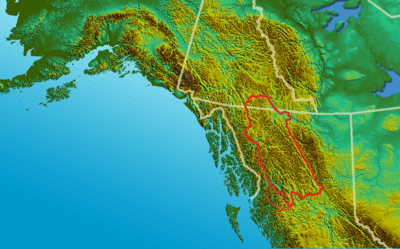
The Interior Mountains, also called the Northern Interior Mountains and Interior Ranges, are the semi-official names[1] for a huge area that comprises much of the northern two thirds of the Canadian province of British Columbia and a large area of southern Yukon.
| Interior Mountains | |
|---|---|
| Northern Interior Mountains "Interior Ranges" | |
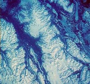 Satellite photo of the Spectrum Range | |
| Elevation | 2,748 m (9,016 ft) |
| Dimensions | |
| Area | 221,310 km2 (85,450 sq mi) |
| Geography | |
| Country | Canada |
| Province/Territory | British Columbia and Yukon |
| Range coordinates | 57°55′36.8″N 126°50′53.9″W |
| Parent range | Interior System |
There are four main groupings, the Skeena, Cassiar and Omineca Mountains to the north of the Interior Plateau between the Coast Mountains to the west and the Rocky Mountains to the east, and the Hazelton Mountains along the Interior Plateau's northwestern flank against the Coast Mountains, extending from the Bulkley Ranges south to the Bella Coola River. Included within the Interior Mountains system is the Stikine Plateau, which contains a number of sub-plateaus and various mountain ranges and is located west of the Cassiars, north of the Skeenas, and to the east of the Boundary Ranges of the Coast Mountains.
Most of the thousands of summits in the Interior Mountains are unnamed, and they are mostly uninhabited and undeveloped.
Component ranges and plateaus
Notable summits and features, if any, are included.
Tagish Highland
- NB sometimes defined as part of the Coast Mountains
- Bennett Range
- Sloko Range
- White Range
Tahltan Highland
- NB sometimes defined as part of the Coast Mountains
Tanzilla Plateau
- French Range
- Hotailuh Range
Parks, Protected Areas and Ecological Reserves
National Parks
- Chilkoot Trail National Historic Site
Provincial Parks and Protected Areas
- Atlin Provincial Park and Recreation Area
- Babine Lake Marine Provincial Park
- Babine Mountains Provincial Park
- Babine River Corridor Provincial Park
- Bear Glacier Provincial Park
- Boya Lake Provincial Park
- Bulkley Junction Provincial Park
- Call Lake Provincial Park
- Chase Provincial Park
- Chukachida River Protected Area
- Damdochax Protected Area
- Denetiah Provincial Park
- Driftwood Canyon Provincial Park
- Dune Za Keyih Provincial Park and Protected Area (Frog-Gataga Wilderness)
- Ed Bird-Estella Provincial Park
- Finlay-Russel Provincial Park and Protected Area
- Iskut River Hot Springs Provincial Park
- Kinaskan Lake Provincial Park
- Little Andrews Bay Marine Provincial Park
- Meziadin Lake Provincial Park
- Mount Blanchet Provincial Park
- Mount Edziza Provincial Park and Recreation Area
- Nation Lakes Provincial Park
- Netalzul Meadows Provincial Park
- Nilkitkwa Lake Provincial Park
- Ningunsaw Provincial Park
- Omineca Provincial Park and Protected Area
- Pitman River Protected Area
- Rainbow Alley Provincial Park
- Ross Lake Provincial Park
- Rubyrock Lake Provincial Park
- Seeley Lake Provincial Park
- Seven Sisters Provincial Park and Protected Area
- Spatsizi Headwaters Provincial Park
- Spatsizi Plateau Wilderness Provincial Park
- Sustut Provincial Park and Protected Area
- Swan Lake/Kispiox River Provincial Park
- Tatlatui Provincial Park
- Todagin South Slope Provincial Park
- Tuya Mountains Provincial Park
- Tweedsmuir North Provincial Park and Protected Area
- Tweedsmuir South Provincial Park
- Tyhee Lake Provincial Park
- Wistaria Provincial Park
Park and preservation proposals
See also
References
- S. Holland, Landforms of British Columbia, Province of British Columbia, 1976
- Both terms were coined by British Columbia government geographer Stuart Holland in the course of writing his Landforms of British Columbia, which is a definitive volume on the province's topography and toponymy written in 1964. This work is used as the basis for official toponymies such as those in the provincial gazette and the British Columbia Geographic Names Information System Database (BCGNIS), which is the official registry of the province's geographic names. The term Interior Mountains, used by Holland throughout his work and as a chapter heading describing the mountain system in question, is not present in the Geographical Names Database despite being a chapter heading and appearing on Holland's map of the province's landform systems. He suggests, also, the term "Northern Interior Mountains", partly because the mountain system is in a region also known as the Northern Interior, but also to potentially distinguish this mountain system from mountain ranges farther south in the province's Interior, including many on the Interior Plateau. In his exegesis he decides on interior Mountains for reasons of brevity.