Indonesian National Route 9
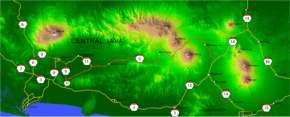
Indonesian National Route 9 is a main road which connects Ajibarang and Secang.[1][2] The route is a middle route which pass Dieng Plateau and located in Central Java.
| ||||
|---|---|---|---|---|
 | ||||
| Route information | ||||
| Length | 177 km (110 mi) | |||
| Major junctions | ||||
| West end | Ajibarang | |||
| Indonesian National Route 6 Indonesian National Route 8 Indonesian National Route 10 Indonesian National Route 14 | ||||
| East end | Secang | |||
| Highway system | ||||
Roads and Highways in Indonesia
| ||||

Route
Ajibarang - Purwokerto - Sokaraja - Kaliori - Banyumas - Klampok - Banjarnegara - Selokromo - Wonosobo - Kretek - Parakan - Bulu - Kedu - Temanggung - Kranggan - Secang
References
- "Archived copy" (in Indonesian). Archived from the original on 2013-09-27. Retrieved 2013-05-18.CS1 maint: archived copy as title (link)
- (in Indonesian)Road and Transport map of Java for 2010 Eid Mubarak Going-Home Event by POLRI, Department of Transportation, Department of National Projects, and Jasa Marga

This article is issued from Wikipedia. The text is licensed under Creative Commons - Attribution - Sharealike. Additional terms may apply for the media files.