Indiana State Road 450
State Road 450 is a winding route in southern Indiana that terminates at both ends at its parent route, U.S. Route 50. It covers a distance of about 25 miles (40 km).
| ||||
|---|---|---|---|---|
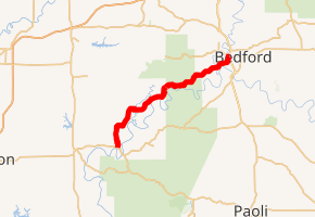
SR 450 highlighted in red | ||||
| Route information | ||||
| Maintained by INDOT | ||||
| Length | 24.956 mi[1] (40.163 km) | |||
| Existed | 1932[2]–present | |||
| Major junctions | ||||
| West end | ||||
| East end | ||||
| Location | ||||
| Counties | Martin, Lawrence | |||
| Highway system | ||||
| ||||

Route description
State Road 450 begins just north of the town of Shoals in Martin County and runs northeast to rejoin U.S. Route 50 in Bedford in Lawrence County.
Major intersections
| County | Location | mi[1] | km | Destinations | Notes |
|---|---|---|---|---|---|
| Martin | Shoals | 0.000 | 0.000 | Western Terminus of SR 450 | |
| Lawrence | Bedford | 24.783 | 39.884 | Eastern terminus of SR 158 | |
| 24.956 | 40.163 | Eastern terminus of SR 450 | |||
| 1.000 mi = 1.609 km; 1.000 km = 0.621 mi | |||||
References
- Indiana Department of Transportation (July 2016). Reference Post Book (PDF). Indianapolis: Indiana Department of Transportation. Retrieved February 2, 2017.
- "New Highways in State's System Total 777 Miles". The Indianapolis News. February 26, 1932. p. 9. Retrieved September 13, 2018 – via Newspapers.com.

This article is issued from Wikipedia. The text is licensed under Creative Commons - Attribution - Sharealike. Additional terms may apply for the media files.