Indiana State Road 157
State Road 157 in the U.S. State of Indiana is a north–south route in Clay, Greene and Owen counties that covers a distance of about 26 miles (42 km).
| ||||
|---|---|---|---|---|
 | ||||
| Route information | ||||
| Maintained by INDOT | ||||
| Length | 26.838 mi[1] (43.192 km) | |||
| Existed | 1932[2]–present | |||
| Major junctions | ||||
| South end | ||||
| North end | ||||
| Location | ||||
| Counties | Clay, Greene, Owen | |||
| Highway system | ||||
| ||||

Route description
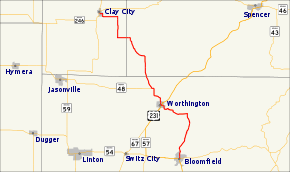
The southern terminus of State Road 157 is at State Road 54 in Bloomfield. It runs north to Worthington where it intersects with U.S. Route 231 and State Road 67 (which are concurrent here). A few miles to the north, it intersects with State Road 48. It then passes through the southwest corner of Owen County with no major intersections and continues into Clay county. Its northern terminus is at State Road 59 and State Road 246 in Clay City.
Major intersections
| County | Location | mi[1] | km | Destinations | Notes |
|---|---|---|---|---|---|
| Greene | Bloomfield | 0.000 | 0.000 | Southern terminus of SR 157 | |
| Worthington | 9.511 | 15.306 | Southern end of US 231/SR 67 concurrency | ||
| 9.557 | 15.381 | Northern end of US 231/SR 67 concurrency | |||
| Jefferson Township | 13.066 | 21.028 | Eastern terminus of SR 48 | ||
| Clay | Clay City | 26.838 | 43.192 | Northern terminus of SR 157 | |
1.000 mi = 1.609 km; 1.000 km = 0.621 mi
| |||||
References
- Indiana Department of Transportation (July 2016). Reference Post Book (PDF). Indianapolis: Indiana Department of Transportation. Retrieved February 6, 2017.
- "State Begins Care New Roads". The Daily Reporter. Greenfield. March 23, 1932. p. 4. Retrieved October 4, 2016 – via Newspapers.com.

External links
This article is issued from Wikipedia. The text is licensed under Creative Commons - Attribution - Sharealike. Additional terms may apply for the media files.