Independence Township, Washington County, Ohio
Independence Township is one of the twenty-two townships of Washington County, Ohio, United States. The 2000 census found 387 people in the township.[3]
Independence Township, Washington County, Ohio | |
|---|---|
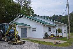 Township hall at Archer's Fork | |
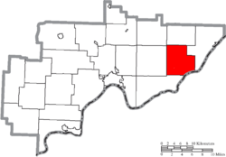 Location of Independence Township in Washington County | |
| Coordinates: 39°28′36″N 81°11′49″W | |
| Country | United States |
| State | Ohio |
| County | Washington |
| Area | |
| • Total | 28.5 sq mi (73.8 km2) |
| • Land | 28.5 sq mi (73.7 km2) |
| • Water | 0.0 sq mi (0.1 km2) |
| Elevation | 955 ft (291 m) |
| Population (2000) | |
| • Total | 387 |
| • Density | 13.6/sq mi (5.2/km2) |
| Time zone | UTC-5 (Eastern (EST)) |
| • Summer (DST) | UTC-4 (EDT) |
| FIPS code | 39-37268[2] |
| GNIS feature ID | 1087134[1] |
Geography
Located in the eastern part of the county along the Ohio River, it borders the following townships:
- Ludlow Township - north
- Grandview Township - east
- Newport Township - south
- Lawrence Township - west
- Liberty Township - northwest
Pleasants County, West Virginia lies across the Ohio River to the southeast.
No municipalities are located in Independence Township.
Name and history
Independence Township was established in 1840.[4] It is the only Independence Township statewide.[5]
Government
The township is governed by a three-member board of trustees, who are elected in November of odd-numbered years to a four-year term beginning on the following January 1. Two are elected in the year after the presidential election and one is elected in the year before it. There is also an elected township fiscal officer,[6] who serves a four-year term beginning on April 1 of the year after the election, which is held in November of the year before the presidential election. Vacancies in the fiscal officership or on the board of trustees are filled by the remaining trustees.
References
- "US Board on Geographic Names". United States Geological Survey. 2007-10-25. Retrieved 2008-01-31.
- "U.S. Census website". United States Census Bureau. Retrieved 2008-01-31.
- Washington County, Ohio — Population by Places Estimates Ohio State University, 2007. Accessed 15 May 2007.
- Hathaway, Seymour J. (1902). History of Marietta and Washington County, Ohio, and Representative Citizens. Biographical Publishing Company. p. 303.
- "Detailed map of Ohio" (PDF). United States Census Bureau. 2000. Retrieved 2007-02-16.
- §503.24, §505.01, and §507.01 of the Ohio Revised Code. Accessed 4/30/2009.
External links
Municipalities and communities of Washington County, Ohio, United States | ||
|---|---|---|
| Cities | 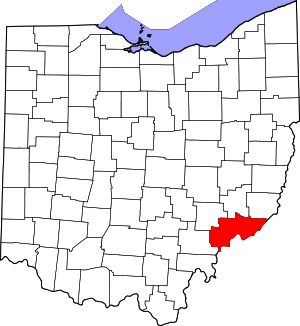 Map of Ohio highlighting Washington County | |
| Villages | ||
| Townships | ||
| CDPs | ||
| Unincorporated communities |
| |