In Buri District
In Buri (Thai: อินทร์บุรี, pronounced [ʔīn bū.rīː]) is the northernmost district (amphoe) of Sing Buri Province in central Thailand.
In Buri อินทร์บุรี | |
|---|---|
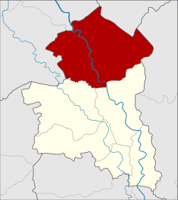 District location in Singburi Province | |
| Coordinates: 15°0′28″N 100°19′37″E | |
| Country | Thailand |
| Province | Sing Buri |
| Seat | In Buri |
| Area | |
| • Total | 314.3 km2 (121.4 sq mi) |
| Population (2007) | |
| • Total | 57,771 |
| • Density | 183.8/km2 (476/sq mi) |
| Time zone | UTC+7 (ICT) |
| Postal code | 16110 |
| Geocode | 1706 |
History
In Buri is an ancient city, one of the major mueang or city states. It was built in the reign of King Ramesuan in 1369. In the Ayutthaya era, the governor of In Buri always was a royal family member because In Buri was a northern frontier city of Ayutthaya. The Thesaphiban administrative reforms of King Rama V downgraded In Buri to a subordinate of Sing Buri in 1895. It was converted into a district of Sing Buri Province later.
Geography
Neighboring districts are (from the north clockwise) Takhli of Nakhon Sawan Province, Ban Mi of Lopburi Province, Mueang Sing Buri and Bang Rachan of Sing Buri Province, and Sapphaya and Sankhaburi of Chai Nat Province.
Administration
The district is divided into 10 sub-districts (tambons), which are further subdivided into 101 villages (mubans). In Buri itself is a sub-district municipality which covers parts of tambon In Buri. There are another 10 tambon administrative organizations (TAO).
| No. | Name | Thai | Pop. |
|---|---|---|---|
| 1. | In Buri | อินทร์บุรี | 11,150 |
| 2. | Prasuk | ประศุก | 6,221 |
| 3. | Thap Ya | ทับยา | 6,161 |
| 4. | Ngio Rai | งิ้วราย | 5,604 |
| 5. | Chi Nam Rai | ชีน้ำร้าย | 4,386 |
| 6. | Tha Ngam | ท่างาม | 5,340 |
| 7. | Nam Tan | น้ำตาล | 3,584 |
| 8. | Thong En | ทองเอน | 7,977 |
| 9. | Huai Chan | ห้วยชัน | 4,909 |
| 10. | Pho Chai | โพธิ์ชัย | 2,439 |
References
External links
- amphoe.com (Thai)
| Historical divisions |
| ||||
|---|---|---|---|---|---|
| Former provinces |
| ||||