Inō Tadataka
Inō Tadataka (伊能 忠敬 February 11, 1745 - May 17, 1818) was a Japanese surveyor and cartographer. He is known for completing the first map of Japan using modern surveying techniques.

Early life
Inō was born in the small village of Ozeki in the middle of Kujūkuri beach, in Kazusa Province (in what is now Chiba Prefecture). He was born to the Jimbo family and his childhood name was Sanjirou. His mother died when he was seven and after a somewhat tumultuous childhood (not uncommon at the time), [1]he was adopted (age 17) by the prosperous Inō family of Sawara (now a district of Katori, Chiba), a town in Shimōsa Province. He ran the family business, expanding its sake brewing and rice-trading concerns, until he retired at the age of 49.
At this time he moved to Edo and became a pupil of astronomer Takahashi Yoshitoki, from whom he learned Western astronomy, geography, and mathematics.
Mission
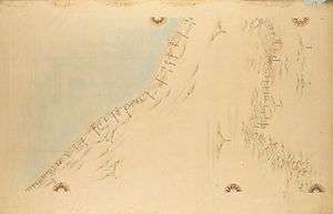
In 1800, after nearly five years of study, the Tokugawa shogunate permitted Inō to perform a survey of the country using his own money. This task, which consumed the remaining 17 years of his life, covered the entire coastline and some of the interior of each of the Japanese home islands. During this period Inō reportedly spent 3,736 days making measurements (and traveled 34,913 kilometres), stopping regularly to present the Shogun with maps reflecting his survey's progress. He produced detailed maps (some at a scale of 1:36,000, others at 1:216,000) of select parts of Japan, mostly in Kyūshū and Hokkaidō.
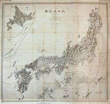
Inō's magnum opus, his 1:216,000 map of the entire coastline of Japan, remained unfinished at his death in 1818 but was completed by his surveying team in 1821. An atlas collecting all of his survey work, Dai Nihon Enkai Yochi Zenzu (ja:大日本沿海輿地全図 Maps of Japan's Coastal Area), was published that year. It had three pages of large scale maps at 1:432,000, showed the entire country on eight pages at 1:216,000, and had 214 pages of select coastal areas in fine detail at 1:36,000. The Inō-zu (Inō's maps), many of which are accurate to 1/1000 of a degree, remained the definitive maps of Japan for nearly a century, and maps based on his work were in use as late as 1924.
Expeditions
Ino's surveys were done in 10 expeditions [3]. The first survey started on June 11, 1800 and included 5 members. This survey was mainly to begin charting the coast of Hokkaido (where Russian ships had come to open trading houses). This survey was done almost entirely by measuring walking steps [4] and taking astronomical observations. They made it to Bekkai 別解 in far Northeast Hokkaido. In total they walked and surveyed 3,244 km.
The results of the first survey, paid for almost entirely by Ino's own funds, helped the Bakufu government understand the significance of the work. For this reason, starting with the second expedition (departing Tokyo in the summer of 1801) he received more support, and the route was more ambitious, covering most of the Eastern seaboard from just south of Tokyo to the far northern tip of Honshu, and then the interior portion on the return trip. This expedition lasted approximately 6 months and covered 3,122 km.
After the second survey, more and more trust was put in Ino's endeavor. By the fifth expedition, there were 19 people involved, they covered almost 7,000 km. On the 8th expedition they covered over 13,000 km in 914 days, most of it in Kyushu. By this time Ino was 70 years old, which was decades older than the average lifespan at that time.
In addition to his maps, Inō produced scholarly works on surveying and mathematics, including Chikyū sokuenjutsu mondō and Kyūkatsuen hassenhō.
Commemoration
Inō is celebrated as one of the 'architects' of modern Japan. A museum, dedicated to his memory, was opened in his former home in Sawara, and in 1996 was designated a National Historic Site.
In November 1995 the Japanese government issued a commemorative 80 yen postage stamp, showing Inō's portrait and a section of his map of Edo.
Most of the complete copies of the atlas have been lost or destroyed (often by fire), although a mostly-complete copy of the large-scale map was discovered in the collection of the U.S. Library of Congress in 2001.
See also
![]()
References
- 渡辺, 一郎 (2003). 伊能忠敬測量隊. 東京: 小学館. p. 6-7. ISBN 4-09-626205-6.
- National Diet Library Digital Collection Dai Nihon Enkai Yochi Zenzu No.76
- A concise review can be found in 渡辺一郎、鈴木純子、伊能忠敬の地図をよむ (Reading Ino Tadataka's Map)
- The exact distance Ino had set and stabilized by surveying parts of Tokyo. See 渡辺一郎、op. cit、pp. 76-83.
- Ogawa, Florence. (1997). "Ino Tadataka, les premiers pas de la geographie moderne au Japon," Ebisu, Vol. 16, pp. 95–119.
| Authority control |
|
|---|