Idaho State Highway 38
Idaho State Highway 38 (SH-38) is a state highway that spans 23.438 miles (37.720 km) east-west in Oneida County in the southeast Idaho, United States from Holbrook east to Interstate 15 (I-15) in Malad City.[1][2]
| ||||
|---|---|---|---|---|
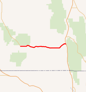
SH-38 highlighted in red | ||||
| Route information | ||||
| Maintained by ITD | ||||
| Length | 23.438 mi[1] (37.720 km) | |||
| Major junctions | ||||
| West end | North Holbrook Road / Stone Road in Holbrook | |||
| East end | ||||
| Location | ||||
| Counties | Oneida | |||
| Highway system | ||||
| ||||

Route description
SH-38 begins at an intersection with North Holbrook Road and Stone Road in Holbrook. (From the western terminus of SH 38 the North Holbrook Road continues northwest to the Power County line and the southern terminus of Idaho State Highway 37.) From its western terminus, SH 38 heads east through a rural area between sections of the Curlew National Grassland. It takes a more crooked route east outside of Holbrook, intersecting Arbon Valley Road. From here, the highway enters mountainous terrain, passing Holbrook Summit at an elevation of 6,104 feet (1,860 m). After passing through the mountains, SH 38 enters a rural area and passes through the community of Pleasantview. The highway turns northeast toward Malad City, passing the Malad City Airport. After entering Malad City, the route turns eastward, passing through a mixed residential and business district. SH 38 leaves the Malad City limits before reaching its eastern terminus at Exit 13 of I-15. Immediately beyond I-15 is the road which was formerly U.S. Route 191.[1][2]
History
Between 1927 and 1937, the SH 38 designation was assigned to a route (which, by 1927, had been previously designated as SH 32) that began in Roy and headed east and then northeast to Arbon, north to Pauline (along what is now the Arbon Highway) and then (along what is now the Bannock Highway) north to Crystal, and on to terminate in at the former routing of US-91 in Portneuf.[3][4]
The route which is now SH 38 was marked as part of former routing of SH 33 by 1927.[3] Between 1927 and 1937, SH 33 was changed to SH 37. (By 1927 the north-south route through Malad City was designated as SH 21, but by 1937 it had been changed to SH 36.)[3][4] By 1956, the southern terminus of SH 38 had changed from SH 37 in Roy to SH 37 east of Holbrook (via Buist to Arbon)[5] Eventually, the routing of SH 38 was changed to its current route, with the roads through Buist, Arbon, and Crystal to Portneuf being entirely removed from the state highway system.
Major intersections
The entire route is in Oneida County. [2]
| Location[2] | mi[1] | km | Destinations[2] | Notes | |
|---|---|---|---|---|---|
| Holbrook | 0.000 | 0.000 | North Holbrook Road north - Rockland & Stone Road south - Stone | Western terminus; North Holbrook Road was formerly SH 37 | |
| | 4.373 | 7.038 | North Arbon Valley Road/17200 West north - Arbon, Pauline | Former routing of SH 38 | |
| Pleasantview | 16.476 | 26.516 | South 5400 West - Samaria | ||
| Malad City | 23.438 | 37.720 | I-15 exit 13; eastern terminus. | ||
| 1.000 mi = 1.609 km; 1.000 km = 0.621 mi | |||||
References
- "State Highway 38" (PDF). itd.idaho.gov. Idaho Transportation Department. 26 Jan 2016. Retrieved 24 Dec 2016.
- Google (24 Dec 2016). "Overview map of State Highway 38" (Map). Google Maps. Google. Retrieved 24 Dec 2016.
- "Rand McNally Junior Auto Road Map: Idaho" (Map). davidrumsey.com. Rand McNally Company. 1927. Retrieved 24 Dec 2016.
- "Texaco Road Map: Idaho, Montana, Wyoming" (Map). davidramsey.com. Rand McNally Company and Texas Company. 1937. Retrieved 24 Dec 2016.
- "Shell Map of Idaho and Wyoming" (Map). davidramsey.com. Shell Oil Company. 1956. Retrieved 24 Dec 2016.
External links
| Wikimedia Commons has media related to Idaho State Highway 38. |