Horská Kvilda
Horská Kvilda (German: Innergefild) is a village and municipality (obec) in Klatovy District in the Plzeň Region of the Czech Republic.
Horská Kvilda | |
|---|---|
Municipality | |
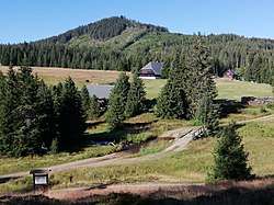 Houses in the village | |
 Flag  Coat of arms | |
 Horská Kvilda | |
| Coordinates: 49°3′33″N 13°33′30″E | |
| Country | |
| Region | Plzeň |
| District | Klatovy |
| Area | |
| • Total | 29.91 km2 (11.55 sq mi) |
| Elevation | 1,070 m (3,510 ft) |
| Population (2020)[1] | |
| • Total | 60 |
| • Density | 2.0/km2 (5.2/sq mi) |
| Postal code | 341 92 to 385 01 |
| Website | http://www.horskakvilda.eu |
The municipality covers an area of 29.91 square kilometres (11.55 sq mi), and has a population of around 60.
Horská Kvilda lies approximately 43 kilometres (27 mi) south-east of Klatovy, 78 km (48 mi) south of Plzeň, and 130 km (81 mi) south-west of Prague.
References
| Wikimedia Commons has media related to Horská Kvilda. |
- "Population of municipalities of the Czech Republic". Czech Statistical Office. 1 January 2020.
This article is issued from Wikipedia. The text is licensed under Creative Commons - Attribution - Sharealike. Additional terms may apply for the media files.