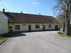
Horní Kněžeklady
Horní Kněžeklady is a village and municipality (obec) in České Budějovice District in the South Bohemian Region of the Czech Republic.
Horní Kněžeklady | |
|---|---|
Municipality | |
 Municipal office | |
 Flag  Coat of arms | |
 Horní Kněžeklady | |
| Coordinates: 49°11′38″N 14°28′53″E | |
| Country | |
| Region | South Bohemian |
| District | České Budějovice |
| Area | |
| • Total | 7.84 km2 (3.03 sq mi) |
| Elevation | 493 m (1,617 ft) |
| Population (2006) | |
| • Total | 112 |
| • Density | 14/km2 (37/sq mi) |
| Postal code | 375 01 |
| Website | www |
The municipality covers an area of 7.84 square kilometres (3.03 sq mi), and has a population of 112 (as at 3 July 2006).
Horní Kněžeklady lies approximately 25 kilometres (16 mi) north of České Budějovice and 100 km (62 mi) south of Prague.
This article is issued from Wikipedia. The text is licensed under Creative Commons - Attribution - Sharealike. Additional terms may apply for the media files.