Hook of Holland
Hook of Holland (Dutch: Hoek van Holland, pronounced [ˈɦuk fɑn ˈɦɔlɑnt] (![]()
Hook of Holland Hoek van Holland | |
|---|---|
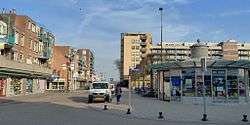 Hook of Holland town centre | |
| Coordinates: 51°58′52″N 4°7′43″E | |
| Country | Netherlands |
| Province | South Holland |
| Municipality | Rotterdam |
| Area | |
| • Total | 14.1 km2 (5.4 sq mi) |
| Population (1 July 2008)[1] | 9,382 |
| Major roads | N211 N220 |
| Dialing code | 0174 |


Towns near "the Hook" (Dutch: "de Hoek") include Monster, 's-Gravenzande, Naaldwijk and Delft to the northeast, and Maassluis to the southeast. On the other side of the river is the Europort and the Maasvlakte. The wide sandy beach, one section of which is designated for use by naturists, runs for approximately 18 kilometres to Scheveningen and for most of this distance is backed by extensive sand dunes through which there are foot and cycle paths.
On the north side of the New Waterway, to the west of the town, is a pier, part of which is accessible to pedestrians and cyclists.
The Berghaven is a small harbour on the New Waterway where the Rotterdam and Europort pilots are based. This small harbour is only for the use of the pilot service, government vessels and the Hook of Holland lifeboat.
History
The Hook of Holland area was created as a sandbar in the Meuse estuary, when it became more and more silted after St. Elizabeth's flood of 1421. All kinds of plans were designed to improve the shipping channel to Rotterdam. In 1863 it was finally decided to construct the New Waterway which was dug between 1866 and 1868. The route ran through the Hook of Holland, where a primitive settlement, Old Hook (Oude Hoek - nowadays the Zuidelijk Strandcentrum), was created. Many workers and senior employees of the Rijkswaterstaat settled in Old Hook.
The Hook initially fell under the administrative authority of 's-Gravenzande. An attempt by the inhabitants to transform the place into an independent municipality failed and, on 1 January 1914, Hook of Holland was added to Rotterdam. After the First World War the village started to develop into a seaside resort. It has since been informally known as 'Rotterdam by the sea'.
During World War II, the Hook was one of the most important places for the Wehrmacht to hold because of its harbour, which comprised an important and strategic part of the Atlantic Wall.
Hook of Holland already had a ward council in 1947. Hook of Holland has been a borough since 1973. In 2014 it was replaced by an 'area committee'.
Transport links
Railways
The Schiedam–Hoek van Holland railway is a 24-kilometre branch line from Schiedam Centrum station via Vlaardingen and Maassluis. The final two stations on the line are located within the town. Hoek van Holland Haven, the penultimate station, is close to the town centre, adjacent to the ferry terminal and the small harbour, the Berghaven. Hoek van Holland Strand, the terminus, is closest to the beach.
The railway line opened for service in 1893 and was electrified in 1935. International trains ran from Berlin and Moscow to connect these with London via the ferry service. Services on the line to Rotterdam Centraal station were being operated by NS every half hour during the day until April 2017, when the line was closed for conversion to metro standards. It was expected to reopen in September 2018 but has been brought to end of July 2019, as an extension of the Rotterdam Metro, but will not connect directly to Rotterdam Centraal as a change will be necessary.
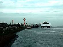
Ferry
Hoek van Holland is also the location of an international ferry terminal, where service to eastern England has operated from since 1893, uninterrupted except for during the two World Wars. Currently, two routes are being operated: one, a day and night freight and passenger service, to Harwich, Essex and the other, a night, freight-only service to North Killingholme Haven, Lincolnshire. The passenger ferry service is operated by Stena Line as part of the Dutchflyer rail-ferry service between Hook van Holland Haven station and Harwich International station in England, from which Greater Anglia provides service to Liverpool Street station in central London.
A local ferry operated by RET links the Hook with the Maasvlakte part of the Port of Rotterdam.
Notable people
- Jan Knippenberg (1948 in Hoek van Holland - 1995) a Dutch ultrarunner and historian, in 1974 he ran from Hoek van Holland to Stockholm (1600 km) in 18 days
- Richard de Mos (born 1976) a Dutch PVV politician, climate change sceptic, brought up in Hoek van Holland.
- Jesper Leerdam (born 1987 in Hoek van Holland) a Dutch footballer currently playing for Dayton Dutch Lions
- Roy Kortsmit (born 1992 in Hoek van Holland) a Dutch professional footballer who currently plays as a goalkeeper for Sparta Rotterdam
- Bryan Janssen (born 1995 in Hoek van Holland) a Dutch professional footballer who plays for FC Dordrecht, as a goalkeeper
References
Notes
- "Bevolkingsmonitor 2e kwartaal 2008" (PDF). Centrum voor Onderzoek en Statistiek Rotterdam. Archived from the original (PDF) on 24 July 2011. Retrieved 27 July 2008.
- Van in isolation: [vɑn].
Bibliography
- Hendy, John; Cowsill, Miles; Brown, Stephen (2010). Harwich - Hook of Holland 1893-2010. Ramsey, Isle of Man: Ferry Publications. ISBN 9781906608101.
External links
| Wikivoyage has a travel guide for Hook of Holland. |
Boroughs of Rotterdam | ||
|---|---|---|
| Authority control |
|
|---|