Hinton, New South Wales
Hinton is a suburb of the Port Stephens local government area in the Hunter Region of New South Wales, Australia.[3] Primarily rural, the largest population centre is the township of Hinton, which is situated on the Paterson River, near to the confluence of the Hunter and Paterson rivers.[4]
| Hinton New South Wales | |||||||||||||||
|---|---|---|---|---|---|---|---|---|---|---|---|---|---|---|---|
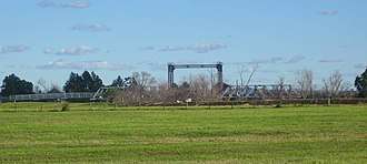 Historic Hinton bridge, built in 1901 | |||||||||||||||
Hinton | |||||||||||||||
| Coordinates | 32°43′S 151°39′E | ||||||||||||||
| Population | 448 (2016 census)[1] | ||||||||||||||
| • Density | 45.71/km2 (118.4/sq mi) | ||||||||||||||
| Postcode(s) | 2321 | ||||||||||||||
| Elevation | 6 m (20 ft)[Note 1] | ||||||||||||||
| Area | 9.8 km2 (3.8 sq mi)[Note 2] | ||||||||||||||
| Time zone | AEST (UTC+10) | ||||||||||||||
| • Summer (DST) | AEDT (UTC+11) | ||||||||||||||
| Location |
| ||||||||||||||
| LGA(s) | Port Stephens Council | ||||||||||||||
| Region | Hunter | ||||||||||||||
| County | Durham[2] | ||||||||||||||
| Parish | Seaham[2] | ||||||||||||||
| State electorate(s) | Port Stephens | ||||||||||||||
| Federal Division(s) | Paterson | ||||||||||||||
| |||||||||||||||
Floods
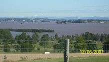
Due to the close proximity of the Hunter and Paterson rivers and the low elevation of surrounding ground the town is often isolated for a number of days during periods of exceptionally high rainfall. Most recently this happened in March 2000 and June 2007.

Heritage listings
Hinton has a number of heritage-listed sites, including:
- Hinton-Morpeth Road: Paterson River bridge[5]
Population
In the 2016 Census, there were 448 people in Hinton. 89.9% of people were born in Australia and 95.7% of people spoke only English at home. The most common responses for religion were Catholic 33.5% and Anglican 28.8%.[1]
Notes
- This is the average elevation of the township. The surrounding farmland is almost at river level as shown on 1:100000 map 9232 NEWCASTLE.
- Area calculation is based on 1:100000 map 9232 NEWCASTLE.
References
- Australian Bureau of Statistics (27 June 2017). "Hinton (State Suburb)". 2016 Census QuickStats. Retrieved 16 June 2019.


- "Hinton". Geographical Names Register (GNR) of NSW. Geographical Names Board of New South Wales. Retrieved 27 May 2008.
- "Suburb Search - Local Council Boundaries - Hunter (HT)". New South Wales Division of Local Government. Archived from the original on 7 June 2008. Retrieved 27 May 2008.
- "Hinton". Land and Property Management Authority - Spatial Information eXchange. New South Wales Land and Property Information. Retrieved 27 May 2008.
- "Hinton Bridge over Paterson River". New South Wales State Heritage Register. Office of Environment and Heritage. H01470. Retrieved 18 May 2018.