Hinnøya
Hinnøya is the fourth largest island in Norway (the largest island in Norway when you ignore the Svalbard archipelago). The 2,204.7-square-kilometre (851.2 sq mi) lies just off the western coast of Northern Norway.[1] The island sits on the border of Nordland and Troms og Finnmark counties. The western part of the island is in the district of Vesterålen, the southwestern part is in the Lofoten district, the southeastern part is in the Ofoten district, and the northeastern part is in Southern Troms.[2]
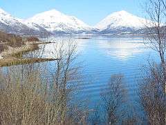
 View of Gullesfjordbotn, at the head of Gullesfjorden, partly a nature reserve | |
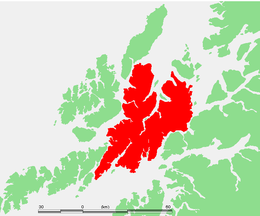 | |
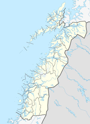 Hinnøya Location of the island  Hinnøya Hinnøya (Troms og Finnmark)  Hinnøya Hinnøya (Norway) | |
| Geography | |
|---|---|
| Location | Northern Norway |
| Coordinates | 68.3231°N 15.4039°E |
| Area | 2,204.7 km2 (851.2 sq mi) |
| Area rank | 4th in Norway (1st outside of Svalbard) |
| Length | 80 km (50 mi) |
| Width | 55 km (34.2 mi) |
| Highest elevation | 1,262 m (4,140 ft) |
| Highest point | Møysalen |
| Administration | |
Norway | |
| County | Troms og Finnmark, Nordland |
| Municipalities | Harstad, Kvæfjord, Lødingen, Sortland, Andøy, Hadsel, Vågan, Tjeldsund |
| Largest settlement | Harstad (pop. 23,242) |
Nordland county | |
| Area covered | 1,275 km2 (492 sq mi; 57.8%) |
Troms og Finnmark county | |
| Area covered | 930 km2 (360 sq mi; 42.2%) |
| Demographics | |
| Population | 32,688 (2017) |
| Pop. density | 14.8/km2 (38.3/sq mi) |
As of 2017, Hinnøya had a population of 32,688.[2] The only town on the island is the town of Harstad. Some of the larger villages include Borkenes, Lødingen, Sigerfjord, and Sørvik. The island is split between the municipalities of Harstad and Kvæfjord in Troms og Finnmark county, as well as Andøy, Hadsel, Lødingen, Sortland, Tjeldsund and Vågan in Nordland county.[2]
Name
The Old Norse form of the name was just Hinn (the suffix -øya meaning "the island" was added later). The large island is almost divided in two parts by the Gullesfjorden and Kanstadfjorden, and the old name is probably derived from an old verb with the meaning "cleave", "split", or "cut".[2]
Geography
| Borkenes/Kvæfjord (1961-90) | ||||||||||||||||||||||||||||||||||||||||||||||||||||||||||||
|---|---|---|---|---|---|---|---|---|---|---|---|---|---|---|---|---|---|---|---|---|---|---|---|---|---|---|---|---|---|---|---|---|---|---|---|---|---|---|---|---|---|---|---|---|---|---|---|---|---|---|---|---|---|---|---|---|---|---|---|---|
| Climate chart (explanation) | ||||||||||||||||||||||||||||||||||||||||||||||||||||||||||||
| ||||||||||||||||||||||||||||||||||||||||||||||||||||||||||||
| ||||||||||||||||||||||||||||||||||||||||||||||||||||||||||||
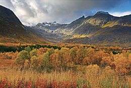
Hinnøya is dissected by several fjords, and two very long ones, Gullesfjorden in the northeast and Øksfjorden in the southwest, almost sever the island in half. There is a 5-kilometre (3 mi) wide isthmus between innermost parts of the two fjords. The island contains a mostly rugged and mountainous terrain, especially the southern part.
The best agricultural area is in the northeast, in Harstad and Kvæfjord Municipalities. The southern part is the location of Møysalen National Park, which includes the highest mountain on the island, the 1,262-metre (4,140 ft) tall Møysalen.[3] In the northwestern part of the island, near the village of Forfjord, there is a nature reserve containing a valley with forests and bogs, including the oldest pine trees in Norway, more than 700 years old.[4]
| County | Area[2] | Population (2016)[2] |
|---|---|---|
| Nordland | 1,275 square kilometres (492 sq mi) | 5,938 |
| Troms | 930 square kilometres (360 sq mi) | 26,750 |
| Total | 2,205 square kilometres (851 sq mi) | 32,688 |
Climate
Borkenes in Kvæfjord (elevation: 36 metres or 118 feet) has mean annual temperature of 4 °C (39 °F) and mean annual precipitation 820 millimetres (32 in). The southern coast of the island in Lødingen municipality is wetter with up to 1,800 millimetres (71 in) precipitation annually.
Transportation
Hinnøya is connected to the mainland by the Tjeldsund Bridge across the Tjeldsundet strait. To the west, it is connected to the island of Langøya by the Sortland Bridge, and to the northwest to the island of Andøya by the Andøy Bridge. It is connected to the Lofoten islands by the Lofoten mainland connection which opened on 1 December 2007. That connection is part of the European Route E10 highway. The highway runs near Møysalen National Park. There is also a ferry connection in the southeast between the village of Lødingen and the village of Bognes on the mainland, crossing the Vestfjorden.
See also
References
- "Norgeskart". Statkart.no. Statkart. Archived from the original on 2014-02-01. Retrieved 2007-09-04.
- Thorsnæs, Geir, ed. (2016-04-24). "Hinnøya". Store norske leksikon (in Norwegian). Kunnskapsforlaget. Retrieved 2018-09-01.
- "Møysalen National Park" (PDF). Archived from the original (PDF) on 2016-03-05. Retrieved 2018-09-01. Cite journal requires
|journal=(help) - "Andøy" (in Norwegian). VisitVesterålen. Retrieved 2018-09-01.
External links

- Wildlife of the Hinnøya region