Hesel
Hesel is a municipality in Leer district. It is situated approximately 12 km (7.5 mi) northeast of Leer, and 25 km (16 mi) east of Emden.
Hesel | |
|---|---|
 Coat of arms | |
Location of Hesel within Leer district 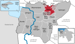  | |
 Hesel  Hesel | |
| Coordinates: 53°18′N 7°36′E | |
| Country | Germany |
| State | Lower Saxony |
| District | Leer |
| Municipal assoc. | Hesel |
| Government | |
| • Mayor | Heiko Müller (CDU) |
| Area | |
| • Total | 44.02 km2 (17.00 sq mi) |
| Highest elevation | 17 m (56 ft) |
| Lowest elevation | 12 m (39 ft) |
| Population (2018-12-31)[1] | |
| • Total | 4,596 |
| • Density | 100/km2 (270/sq mi) |
| Time zone | CET/CEST (UTC+1/+2) |
| Postal codes | 26835 |
| Dialling codes | 0 49 50 |
| Vehicle registration | LER |
| Website | www.hesel.de |
Hesel is also the seat of the Samtgemeinde ("collective municipality") Hesel.
Towns and municipalities in Leer (district) | ||
|---|---|---|
Coat of arms | ||
This article is issued from Wikipedia. The text is licensed under Creative Commons - Attribution - Sharealike. Additional terms may apply for the media files.