Herzogenbuchsee
Herzogenbuchsee is a municipality in the Oberaargau administrative district in the canton of Bern in Switzerland.
Herzogenbuchsee | |
|---|---|
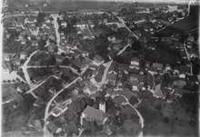
_185.JPG) Herzogenbuchsee town center | |
 Coat of arms | |
Location of Herzogenbuchsee 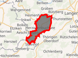
| |
 Herzogenbuchsee Herzogenbuchsee | |
| Coordinates: 47°11′N 7°42′E | |
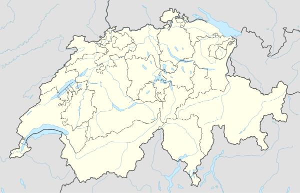
| Country | Switzerland |
| Canton | Bern |
| District | Oberaargau |
| Area | |
| • Total | 9.85 km2 (3.80 sq mi) |
| Elevation | 458 m (1,503 ft) |
| Population (2018-12-31)[3] | |
| • Total | 7,197 |
| • Density | 730/km2 (1,900/sq mi) |
| Postal code | 3360 |
| SFOS number | 0979 |
| Surrounded by | Bettenhausen, Graben, Heimenhausen, Niederönz, Oberönz, Thörigen, Thunstetten, Wanzwil |
| Twin towns | Senica (Slovakia) |
| Website | www SFSO statistics |
The population is 7055 (2011), counting the villages in the Oberaargau. The traditional name was Buchsi.
History
Herzogenbuchsee is built on a moraine of the Rhone Glacier. The area has been settled for at least 10,000 years, with ancient settlements around the Inkwilersee and Burgäschisee. There is also evidence of Roman buildings from approximately 200 CE near the current Reformed Church.
The first documented use of the name puhsa[4] (pronounced Buchsa, in Latin buxum, meaning "box") is found in the writings of Saint Gallus in 886 CE. In 1220 it was mentioned as Buchse and to distinguish it from Münchenbuchsee, in 1301 it was first mentioned as Herzogenbuchze.[4]
It was ruled by Burgundy, the Zähringer, the Kyburger, and finally, brought under the Altberni sovereignty.
On January 1, 2008, the municipality of Oberönz became part of the municipality of Herzogenbuchsee.[5]
Geography
Before the merger, Herzogenbuchsee had an area of 6.8 km2 (2.6 sq mi). Of this area, 35.1% is used for agricultural purposes, while 35% is forested. The rest of the land, (29.9%) is settled.[6]
Following the merger of Oberönz into Herzogenbuchsee, the new municipality has an area, as of 2009, of 9.83 km2 (3.80 sq mi). Of this area, 3.7 km2 (1.4 sq mi) or 37.6% is used for agricultural purposes, while 3.38 km2 (1.31 sq mi) or 34.4% is forested. Of the rest of the land, 2.66 km2 (1.03 sq mi) or 27.1% is settled (buildings or roads), 0.02 km2 (4.9 acres) or 0.2% is either rivers or lakes and 0.06 km2 (15 acres) or 0.6% is unproductive land.[7]
Of the built up area, industrial buildings made up 3.1% of the total area while housing and buildings made up 14.2% and transportation infrastructure made up 7.5%. while parks, green belts and sports fields made up 1.5%. 34.0% of the total land area is heavily forested. Of the agricultural land, 30.9% is used for growing crops and 6.1% is pastures. All the water in the municipality is in rivers and streams.[7] The elevation of the train station is 465 m (1,526 ft).[8]
Demographics
Herzogenbuchsee has a population (as of 31 December 2018) of 7,200.[9] As of 2007, 1,036 are foreign nationals.[8] Over the last 10 years the population has grown at a rate of 6.1%. Most of the population (as of 2000) speaks German (88.9%), with Italian being second most common ( 3.5%) and Albanian being third ( 2.6%).
In the 2007 election the most popular party was the SVP which received 32.1% of the vote. The next three most popular parties were the SPS (23.2%), the FDP (20.8%) and the Green Party (9.5%).
The age distribution of the population (as of 2000) is children and teenagers (0–19 years old) make up 22% of the population, while adults (20–64 years old) make up 59.6% and seniors (over 64 years old) make up 18.4%. In Herzogenbuchsee about 71.2% of the population (between age 25-64) have completed either non-mandatory upper secondary education or additional higher education (either university or a Fachhochschule).
Herzogenbuchsee has an unemployment rate of 1.88%. As of 2005, there were 31 people employed in the primary economic sector and about 9 businesses involved in this sector. 1344 people are employed in the secondary sector and there are 78 businesses in this sector. 1931 people are employed in the tertiary sector, with 249 businesses in this sector.[6] The historical population is given in the following table:[4]
| year | population |
|---|---|
| 1764 | 481 |
| 1850 | 1,525 |
| 1900 | 2,533 |
| 1950 | 3,790 |
| 2000 | 5,338 |
Notable people
- Pierre du Bois de Dunilac (1943 at Herzogenbuchsee – 2007 in Pully) a Swiss writer, political scientist, philanthropist and humanist
References
- http://www.herzogenbuchsee.ch/topic2664/story24349.html; section, verse, paragraph, or clause: Herzogenbuchsee in Zahlen; retrieved: 24 September 2019; publication date: 31 December 2018; official website: http://www.herzogenbuchsee.ch/topic2604.html.
- "Arealstatistik Standard - Gemeinden nach 4 Hauptbereichen". Federal Statistical Office. Retrieved 13 January 2019.
- "Ständige Wohnbevölkerung nach Staatsangehörigkeitskategorie Geschlecht und Gemeinde; Provisorische Jahresergebnisse; 2018". Federal Statistical Office. 9 April 2019. Retrieved 11 April 2019.
- Herzogenbuchsee in German, French and Italian in the online Historical Dictionary of Switzerland.
- BSG 152.01 / BAG 07-139 Archived 2011-07-17 at the Wayback Machine Die Justizkommission des Grossen Rats des Kantons Bern (Justice Commission of the High Council of Canton Bern) decision of 16 October 2007. (in German) accessed 16 July 2009
- Swiss Federal Statistical Office Archived 2016-01-05 at the Wayback Machine accessed 21-Jul-2009
- Swiss Federal Statistical Office-Land Use Statistics 2009 data (in German) accessed 25 March 2010
- Herzogenbuchsee Website-Numbers (in German) accessed 21 July 2009
- Swiss Federal Statistical Office - STAT-TAB, online database – Ständige und nichtständige Wohnbevölkerung nach institutionellen Gliederungen, Geburtsort und Staatsangehörigkeit (in German) accessed 23 September 2019
External links
| Wikimedia Commons has media related to Herzogenbuchsee. |
- Official website (in German)
- Herzogenbuchsee in German, French and Italian in the online Historical Dictionary of Switzerland.
- Oberönz in German, French and Italian in the online Historical Dictionary of Switzerland.
Municipalities in the Oberaargau administrative district, Switzerland | ||
|---|---|---|
| ||