Hershey, Pennsylvania
Hershey is an unincorporated community and census-designated place (CDP) in Derry Township, Dauphin County, Pennsylvania, United States. It is known as the home of The Hershey Company, which was founded by candy magnate Milton S. Hershey.
Hershey, Pennsylvania | |
|---|---|
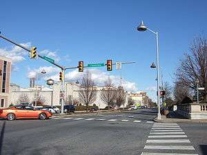 Downtown Hershey at the intersection of Chocolate and Cocoa avenues | |
| Motto(s): The Sweetest Place on Earth[1] | |
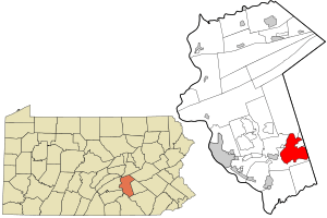 Location in Dauphin County and state of Pennsylvania | |
 Hershey Location within the U.S. state of Pennsylvania  Hershey Hershey (the United States) | |
| Coordinates: 40°16′42″N 76°39′4″W | |
| Country | United States |
| State | Pennsylvania |
| County | Dauphin |
| Township | Derry |
| Area | |
| • Total | 14.4 sq mi (37.3 km2) |
| • Land | 14.4 sq mi (37.2 km2) |
| • Water | 0.08 sq mi (0.2 km2) |
| Elevation | 411 ft (125 m) |
| Population | |
| • Total | 14,257 |
| • Density | 993/sq mi (383.4/km2) |
| Time zone | UTC−5 (Eastern (EST)) |
| • Summer (DST) | UTC−4 (EDT) |
| ZIP Code | 17033 |
| Area code(s) | 717; Exchanges: 312, 520, 531, 533, 534 |
| FIPS code | 34-71385 |
| GNIS feature ID | 1176895 |
| Designated | March 2, 2003[3] |
The community is located 14 miles (23 km) east of Harrisburg and is part of the Harrisburg−Carlisle Metropolitan Statistical Area. Hershey has no legal status as an incorporated municipality, and all its municipal services are provided by Derry Township. The population was 14,257 at the 2010 census.[2]
Geography
Hershey is located in southeastern Dauphin County, in the center and eastern parts of Derry Township. It is bordered to the east by Palmdale (also in Derry Township) and by Campbelltown (in South Londonderry Township, Lebanon County). To the west is the borough of Hummelstown. Over half the population of Derry Township is within the Hershey CDP.
According to the U.S. Census Bureau, the Hershey CDP has a total area of 14.4 square miles (37.3 km2), of which 14.4 square miles (37.2 km2) is land and 0.058 square miles (0.15 km2), or 0.41%, is water.[4]
Demographics
2010
As of the 2010 census, there were 14,257 people living there. Hershey was made up of 83.5% White, 6.6% Asian, 6.2% African American, and 3.5% in other categories. 3.4% identify as Hispanic or Latino.[2]
2000
As of the census[5] of 2000, there were 12,771 people, 5,451 households, and 3,297 families residing in the CDP. The population density was 886.5 people per square mile (342.2/km²). There were 5,887 housing units at an average density of 408.7/sq mi (157.7/km²). The racial makeup of the CDP was 91.07% White, 2.12% African American, 0.06% Native American, 4.87% Asian, 0.01% Pacific Islander, 0.49% from other races, and 1.38% from two or more races. Hispanic or Latino were 1.55% of the population.
There were 5,451 households, out of which 24.8% had children under the age of 18 living with them, 50.9% were married couples living together, 7.1% had a female householder with no husband present, and 39.5% were non-families. 33.7% of all households were made up of individuals, and 16.2% had someone living alone who was 65 years of age or older. The average household size was 2.22 and the average family size was 2.86.
In the CDP, the population was spread out, with 20.3% under the age of 18, 7.4% from 18 to 24, 27.0% from 25 to 44, 21.8% from 45 to 64, and 23.5% who were 65 years of age or older. The median age was 42 years. For every 100 females, there were 86.3 males. For every 100 females age 18 and over, there were 82.1 males.
The median income for a household in the CDP was $45,098, and the median income for a family was $63,385. Males had a median income of $42,013 versus $31,086 for females. The per capita for the CDP was $28,487. About 3.8% of families and 6.9% of the population were below the poverty line, including 6.9% of those under age 18 and 4.7% of those age 65 or over.
| Historical population | |||
|---|---|---|---|
| Census | Pop. | %± | |
| 2000 | 12,771 | — | |
| 2010 | 14,257 | 11.6% | |
Transportation
U.S. Route 422 (Chocolate Avenue) runs through the center of Hershey, and U.S. Route 322 passes south of the center. The two highways merge at the western end of Hershey, at an interchange with Pennsylvania Route 39. US 422 leads east 43 miles (69 km) to Reading, while US 322 leads southeast 28 miles (45 km) to Ephrata and west 15 miles (24 km) to Harrisburg, the state capital. Route 39 provides access to Hersheypark and Chocolate World, located in the northern part of the CDP, and continues north 6 miles (10 km) to Interstate 81 at Skyline View.
Hershey is accessible via Harrisburg International Airport, approximately 12 miles (19 km) to the southwest. Amtrak's Keystone Service provides frequent rail service to the nearby towns of Middletown (9 miles), Harrisburg (13 miles) and Elizabethtown Amtrak Station (11 miles), as well as its eastern end in Philadelphia (95 miles). CAT and LT (formerly known as COLT) provide bus service.
From 1944 to 1981, Hershey had its own small general aviation airport on the front lawn of the Milton Hershey Middle School.[6]
Climate
Hershey has a humid continental climate (Dfa), as is very common in Pennsylvania. Temperatures can reach up to 95 °F in the summer, and fall below 20 °F in the winter. The hardiness zones are 6b and 7a.
| Climate data for Hershey, Pennsylvania | |||||||||||||
|---|---|---|---|---|---|---|---|---|---|---|---|---|---|
| Month | Jan | Feb | Mar | Apr | May | Jun | Jul | Aug | Sep | Oct | Nov | Dec | Year |
| Average high °F (°C) | 36 (2) |
40 (4) |
44 (7) |
62 (17) |
71 (22) |
80 (27) |
84 (29) |
82 (28) |
75 (24) |
64 (18) |
52 (11) |
40 (4) |
61 (16) |
| Average low °F (°C) | 20 (−7) |
23 (−5) |
29 (−2) |
39 (4) |
48 (9) |
58 (14) |
62 (17) |
61 (16) |
53 (12) |
42 (6) |
33 (1) |
25 (−4) |
41 (5) |
| Average precipitation inches (mm) | 2.96 (75) |
2.77 (70) |
3.34 (85) |
3.68 (93) |
4.10 (104) |
4.15 (105) |
4.56 (116) |
3.64 (92) |
3.93 (100) |
3.49 (89) |
3.49 (89) |
3.34 (85) |
43.45 (1,103) |
| Source: [7] | |||||||||||||
Education
- Derry Township School District – public school
- The Vista School – a state approved, private school for autistic students aged 3 to 21 years.
- Milton Hershey School – a private philanthropic school founded in 1909 by chocolate magnate Milton Hershey to serve poor children. Currently serves children from pre-kindergarten through twelfth grade.
- Penn State College of Medicine – Medical school affiliated with the Hershey Medical Center
Sports
| Club | League | Venue | Established | Championships won |
|---|---|---|---|---|
| Hershey Bears | AHL, Ice hockey | Giant Center | 1932 | 11 |
Hershey was once home to the Hershey Wildcats of the A-League, a professional soccer team. The team folded after the 2001 season when its owners decided that it would not be successful financially. The Wildcats were named after a popular roller-coaster in Hersheypark. Hershey was also home to the Hershey Impact over the NPSL indoor soccer league.
National Basketball Association player Wilt Chamberlain scored 100 points for the Philadelphia Warriors in a regular season game played at Hersheypark Arena in 1962; his effort remains a single-game record for the league.
Elizabethtown College hosted the 2015 NCAA Division III Wrestling Championships at the Giant Center.
Christian Pulisic, the 21-year-old American soccer player who plays for Chelsea F.C. of England's Premier League and United States men's national soccer team, is from here.
Points of interest

The community is home to The Hershey Company, which makes the well-known Hershey Bar and Hershey's Kisses and is the parent company of the H. B. Reese Candy Company, manufacturer of Reese's Peanut Butter Cups. Hershey's Chocolate World is a factory store and virtual tour ride of The Hershey Company. The original Hershey Chocolate Factory, located downtown along Chocolate Avenue, was closed in 2012 due to high operational costs.[8] Although many of the former factory buildings have been demolished, several were converted to modern office space.[9]
Hershey Entertainment and Resorts Company owns and operates Hersheypark, Hersheypark Stadium, and other attractions such as ZooAmerica and Hershey Gardens, and is a major employer of the community and surrounding area. Every October since 1955, the Antique Automobile Club of America have hosted the AACA Eastern Fall Meet here.[10] Usually referred to simply as "Hershey", this is often claimed to be the world's largest automotive swap meet.[11]
The Penn State Milton S. Hershey Medical Center and the Milton Hershey School for underprivileged youth are also located in Hershey.
The Pennsylvania State Police Academy is located north along Hersheypark Drive. In addition, the Derry Township Police Department is a nationally recognized law enforcement agency.[12]
Hershey is also home to four world-class golf courses, a few museums, The Hotel Hershey, and an opulent spa.[13]
Hersheypark Stadium hosts concerts and sporting events, with a capacity of 30,000. It is also the venue of the Cocoa Bean Game between the Hershey High School and Milton S. Hershey High School football teams.
- AACA Museum, operated by the Antique Automobile Club of America
- GIANT Center, home of the Hershey Bears
- Hershey Area Playhouse[14]
- Hershey Center for Applied Research
- Hershey Lodge and Convention Center
- Hershey Museum
- Hershey Public Library
- Hershey Recreation Center
- Hershey's Chocolate World
- Hersheypark
- Hersheypark Arena
- Hershey-Derry Township Historical Society
- Hotel Hershey
- Indian Echo Caverns
- Milton Hershey School
- Milton S. Hershey Mansion
- Parkview Cross Country Course
- Tanger Outlets
- Tröegs Brewing Company
In popular culture
Hershey Park plays a large role in the American Dad episode "May the Best Stan Win" where Stan must fight his cyborg clone for the affection of his wife Francine. There is even a musical number called "At Hershey Park" sung by a chorus of back-up singers at the park.
In the Mad Men season 6 finale, "In Care Of", Donald Draper makes a pitch that impresses Hershey's executives. He then reverses the effect (and gets himself suspended from the firm) by sharing his sordid background and the role Hershey's candy bars played in it.[15][16]
In The Simpsons episode "Homerland", Homer says: "I’ve never prayed to a city in my life and if I did it’d be Hershey, Pennsylvania.".[17]
Hershey, Pennsylvania was also name dropped in The Good Doctor, when it was revealed that Shaun Murphy's (main character) love interest, Lea (played by Paige Spara) is moving to Hershey, Pa. to work in her family's auto body shop.[18]
Notable people
- Brian Baker, actor, lives in Hershey.
- John Bilbrey, director at McCormick & Company and former CEO and President of Hershey Company, lived in Hershey.
- Michele Buck, CEO and President of the Hershey Company, lives in Hershey.
- Scott Campbell, professional football player in National Football League (NFL), was born and lived in Hershey
- Gigi Cesarè, actress and recording artist
- Deesha Dyer, White House Social Secretary, lived in Hershey
- Garry Gilliam, former Penn State University and current San Francisco 49ers offensive linesman, lived in Hershey.[19]
- Milton S. Hershey, confectioner and philanthropist, founded and lived in Hershey.[20]
- Michael (Mike) Horrocks, First Officer, United Airlines Flight 175, September 11, 2001, was born and lived in Hershey.
- John Huzvar, professional football player in NFL, lived in Hershey.
- Jules Jordan, film director and actor, was born in Hershey.
- Nellie King, former Major League Baseball pitcher for Pittsburgh Pirates, lived in Hershey.
- Kellen Kulbacki, professional baseball player in Major League Baseball, lived in Hershey.
- George M. Leader, Governor of Pennsylvania, lived in Hershey.
- Trymaine Lee, Pulitzer Prize-winning journalist and national reporter for MSNBC, lived in Hershey.
- Mark Malkoff, comedian and writer, lived in Hershey.
- The Ocean Blue, alternative rock band, formed in Hershey.[21]
- John D. Payne, state Congressman, was born in Hershey.
- Christian Pulisic, American soccer player for Chelsea FC and United States men's national soccer team, was born in Hershey.
- Da’Vine Joy Randolph, Tony Award-nominated actress, lived in Hershey.
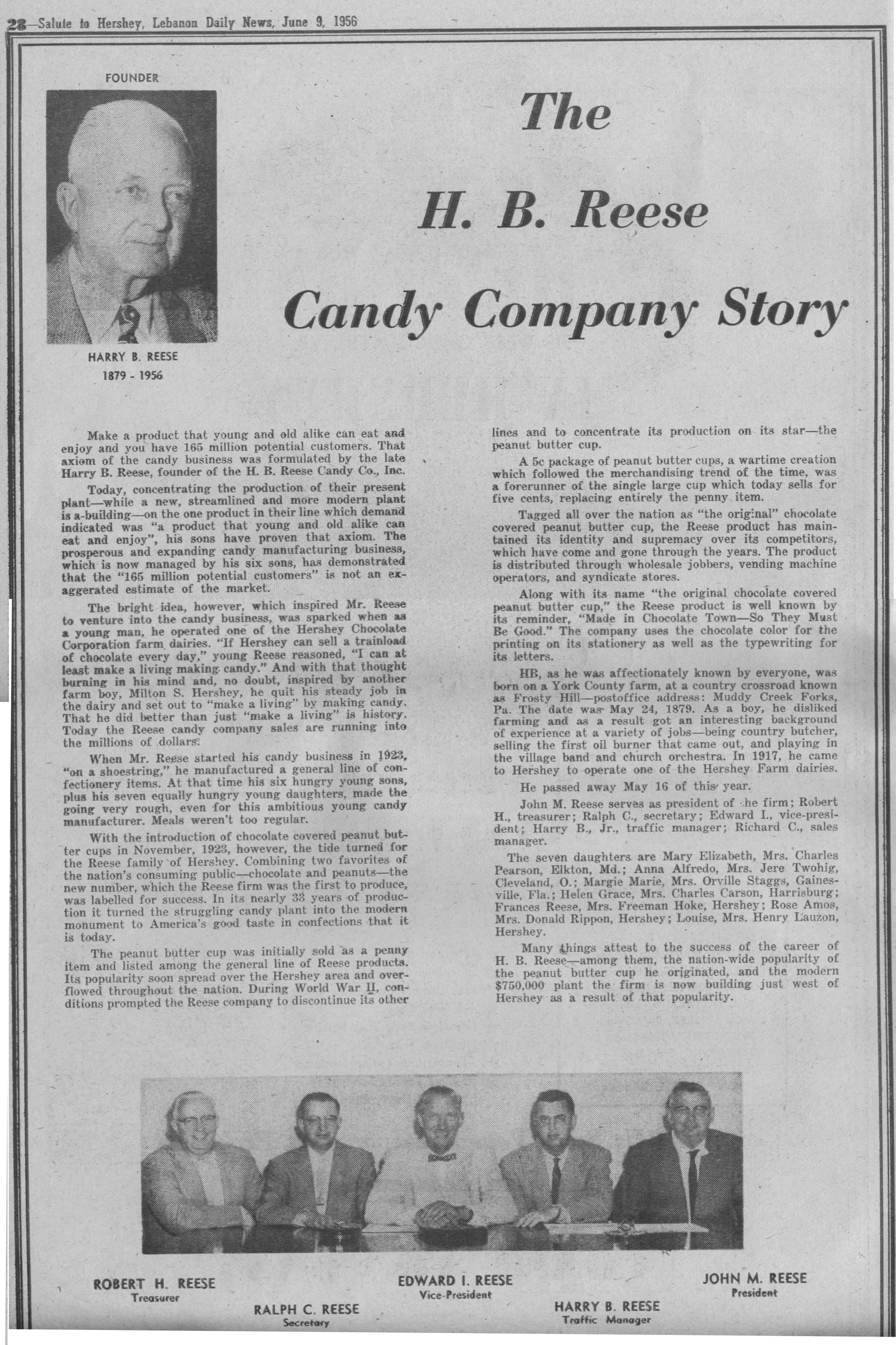
- H.B. Reese, inventor of the No. 1 selling candy brand in the United States, Reese's Peanut Butter Cups,[22] and founder of the H.B. Reese Candy Company, lived and built his two candy factories in Hershey.[23]
- Joe Senser, former NFL tight end for Minnesota Vikings and former board member of the Hershey Trust Company and Hershey Entertainment & Resorts Company, lived in Hershey.
- John B. Sollenberger, sports and entertainment executive, lived in Hershey.
- Andrew Joseph Stack III, who flew a Piper Dakota airplane into an IRS Building in Austin, Texas as a tax protest in 2010, lived in Hershey.
- Jay Taylor, professional football player in NFL, was born and lived in Hershey.
- Dave Twardzik, professional basketball player in NBA, was born in Hershey.
- Chris Villarrial, professional football player in the NFL and head football coach at Saint Francis University, lived in Hershey.
- Richard Winters, major in US Army who lived in Hershey during the later years of his life
- Michelle Wolf, comedian, was born and lived in Hershey.
References
- "Experience Hershey, PA". Hershey Entertainment & Resorts. Retrieved December 22, 2015.
- "2010 Census Interactive Population Search PA – Hershey CDP". U.S. Census Bureau. Archived from the original on December 10, 2014. Retrieved December 10, 2014.
- "PHMC Historical Markers Search" (Searchable database). Pennsylvania Historical and Museum Commission. Commonwealth of Pennsylvania. Retrieved January 25, 2014.
- "Geographic Identifiers: 2010 Demographic Profile Data (G001): Hershey CDP, Dauphin County, Pennsylvania". U.S. Census Bureau, American Factfinder. Archived from the original on February 13, 2020. Retrieved December 22, 2015.
- "U.S. Census website". United States Census Bureau. Retrieved January 31, 2008.
- URL last accessed October 28, 2015.
- "Monthly Averages for Hershey, PA". Weather.com. Retrieved December 29, 2011.
- "Former CEO says Hershey Co. did all it could to save the old factory". PennLive.com.
- Malawskey, Nick (August 7, 2015). "Old is new again at former Hershey factory". PennLive.com. PA Media Group. Retrieved May 4, 2017.
- "Meet History". Hershey, PA: Antoque Automobile Club of America. Archived from the original on October 24, 2018.
- Gross, Ken (October 22, 2015). "Treasure Hunting at Hershey, the World's Largest Old-Car Swap Meet". Car and Driver. Archived from the original on October 14, 2019.
- "Area Information". Retrieved June 25, 2020.
- "Area Information". Retrieved June 25, 2020.
- "Hershey Area Playhouse".
- Alan Sepinwall (June 23, 2013). "What's Alan Watching: Season finale review: 'Mad Men' – 'In Care Of': Both sides, now". Hitfix.
- Emily VanDerWerff (June 24, 2013). "S6/E13: In Care Of". AVClub.
- "D'OH MERLAND". The Simpsons Tapped Out Addicts.
- "Hershey is in tonight's 'The Good Doctor' episode". PennLive.com. Retrieved July 27, 2018.
- Milton Hershey School
- "Hershey, Milton Snavely; 1857-1945". Hershey Community Archives. Archived from the original on December 27, 2017. Retrieved December 26, 2017.
- Wicker, Jewel (November 17, 2015). "Hershey-native Ocean Blue band rewards Chameleon Club, local fans with show celebrating 25-year career". pennlive.com. Retrieved April 16, 2019.
- "Snickers Surging to Top of Global Candy Race". Ad Age. September 20, 2012. Retrieved December 26, 2017.
- "The H.B. Reese Candy Company Story". BradReeseCom. Lebanon Daily News. June 9, 1956. Retrieved December 26, 2017.
External links
| Wikimedia Commons has media related to Hershey, Pennsylvania. |
| Wikivoyage has a travel guide for Hershey, PA. |
- Hershey Community Archives website
- Preserve Hershey organization
- The Sun newspaper
- Hershey New Years.org
Municipalities and communities of Dauphin County, Pennsylvania, United States | ||
|---|---|---|
| City |  | |
| Boroughs | ||
| Townships | ||
| CDPs | ||
| Unincorporated communities |
| |
| Authority control |
|
|---|