Herndon, Kansas
Herndon is a city in Rawlins County, Kansas, United States. As of the 2010 census, the city population was 129.[6]
Herndon, Kansas | |
|---|---|
 Location within Rawlins County and Kansas | |
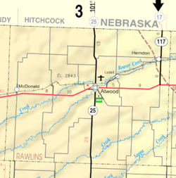 KDOT map of Rawlins County (legend) | |
| Coordinates: 39°54′34″N 100°47′10″W | |
| Country | United States |
| State | Kansas |
| County | Rawlins |
| Founded | 1878 |
| Incorporated | 1906 |
| Named for | William Herndon |
| Area | |
| • Total | 0.26 sq mi (0.67 km2) |
| • Land | 0.26 sq mi (0.67 km2) |
| • Water | 0 sq mi (0 km2) |
| Elevation | 2,671 ft (814 m) |
| Population | |
| • Total | 129 |
| • Estimate (2016)[3] | 130 |
| • Density | 500/sq mi (190/km2) |
| Time zone | UTC-6 (CST) |
| • Summer (DST) | UTC-5 (CDT) |
| ZIP code | 67739 |
| Area code | 785 |
| FIPS code | 20-31475 [4] |
| GNIS ID | 0470915 [5] |
History
Herndon was originally called Pesth (after Budapest, Hungary) and under the latter name was laid out in 1878. It was renamed Herndon in 1879, in honor of William H. Herndon, law partner of Abraham Lincoln.[7] Herndon was incorporated as a city in 1906.[8]
Geography
Herndon is located at 39°54′34″N 100°47′10″W (39.909468, -100.786094).[9] According to the United States Census Bureau, the city has a total area of 0.26 square miles (0.67 km2), all of it land.[1]
Demographics
| Historical population | |||
|---|---|---|---|
| Census | Pop. | %± | |
| 1910 | 273 | — | |
| 1920 | 411 | 50.5% | |
| 1930 | 430 | 4.6% | |
| 1940 | 443 | 3.0% | |
| 1950 | 321 | −27.5% | |
| 1960 | 339 | 5.6% | |
| 1970 | 268 | −20.9% | |
| 1980 | 220 | −17.9% | |
| 1990 | 170 | −22.7% | |
| 2000 | 149 | −12.4% | |
| 2010 | 129 | −13.4% | |
| Est. 2016 | 130 | [3] | 0.8% |
| U.S. Decennial Census | |||
2010 census
As of the census[2] of 2010, there were 129 people, 66 households, and 33 families residing in the city. The population density was 496.2 inhabitants per square mile (191.6/km2). There were 103 housing units at an average density of 396.2 per square mile (153.0/km2). The racial makeup of the city was 94.6% White, 2.3% African American, and 3.1% from two or more races. Hispanic or Latino of any race were 1.6% of the population.
There were 66 households of which 18.2% had children under the age of 18 living with them, 40.9% were married couples living together, 1.5% had a female householder with no husband present, 7.6% had a male householder with no wife present, and 50.0% were non-families. 42.4% of all households were made up of individuals and 13.6% had someone living alone who was 65 years of age or older. The average household size was 1.95 and the average family size was 2.70.
The median age in the city was 51.1 years. 17.8% of residents were under the age of 18; 7% were between the ages of 18 and 24; 16.4% were from 25 to 44; 33.4% were from 45 to 64; and 25.6% were 65 years of age or older. The gender makeup of the city was 51.2% male and 48.8% female.
2000 census
As of the census[4] of 2000, there were 149 people, 83 households, and 37 families residing in the city. The population density was 561.1 people per square mile (213.1/km²). There were 107 housing units at an average density of 402.9 per square mile (153.0/km²). The racial makeup of the city was 99.33% White, and 0.67% from two or more races.
There were 83 households out of which 18.1% had children under the age of 18 living with them, 34.9% were married couples living together, 8.4% had a female householder with no husband present, and 55.4% were non-families. 54.2% of all households were made up of individuals and 33.7% had someone living alone who was 65 years of age or older. The average household size was 1.80 and the average family size was 2.76.
In the city, the population was spread out with 18.8% under the age of 18, 3.4% from 18 to 24, 17.4% from 25 to 44, 20.8% from 45 to 64, and 39.6% who were 65 years of age or older. The median age was 52 years. For every 100 females, there were 101.4 males. For every 100 females age 18 and over, there were 83.3 males.
The median income for a household in the city was $17,250, and the median income for a family was $24,583. Males had a median income of $31,563 versus $11,875 for females. The per capita income for the city was $23,005. There were 7.7% of families and 12.3% of the population living below the poverty line, including 17.8% of under eighteens and 9.8% of those over 64.
Education
The community is served by Rawlins County USD 105 public school district,[10] formed in 2003 by the consolidation of Herndon USD 317 and Atwood USD 318.[11] Residents attend school in Atwood: Rawlins County Elementary School and Rawlins County Junior-Senior High School.[10]
Herndon schools were closed in 2004 through school unification. The Herndon High School mascot was Herndon Beavers.[12]
Notable people
- Rudolph Wendelin, artist behind Smokey Bear.
References
- "US Gazetteer files 2010". United States Census Bureau. Archived from the original on 2012-01-25. Retrieved 2012-07-06.
- "U.S. Census website". United States Census Bureau. Retrieved 2012-07-06.
- "Population and Housing Unit Estimates". Retrieved June 9, 2017.
- "U.S. Census website". United States Census Bureau. Retrieved 2008-01-31.
- "US Board on Geographic Names". United States Geological Survey. 2007-10-25. Retrieved 2008-01-31.
- "2010 City Population and Housing Occupancy Status". U.S. Census Bureau. Retrieved September 1, 2011.
- Kansas State Historical Society (1916). Biennial Report of the Board of Directors of the Kansas State Historical Society. Kansas State Printing Plant. pp. 267.
- Blackmar, Frank Wilson (1912). Kansas: A Cyclopedia of State History, Embracing Events, Institutions, Industries, Counties, Cities, Towns, Prominent Persons, Etc. Standard Publishing Company. pp. 839.
- "US Gazetteer files: 2010, 2000, and 1990". United States Census Bureau. 2011-02-12. Retrieved 2011-04-23.
- "USD 105 Map" (PDF). Kansas Department of Transportation. Retrieved 2020-04-26.
- "School consolidations in Kansas for past decade". The Topeka Capital-Journal. 2011-07-24. Retrieved 2020-04-26.
- "Herndon boys hope to go out is style Friday", The Hays Daily News, 19 February 2004, p.9.
Further reading
External links
| Wikimedia Commons has media related to Herndon, Kansas. |
- City
- Newspapers
- Maps
- Herndon City Map, KDOT
Municipalities and communities of Rawlins County, Kansas, United States | ||
|---|---|---|
| Cities | 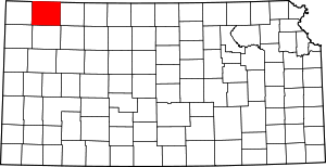 Map of Kansas highlighting Rawlins County | |
| Unincorporated communities | ||
| Ghost town | ||