Henry, Illinois
Henry is a city in Marshall County, Illinois, United States. The population was 2,464 at the 2010 census. It is part of the Peoria, Illinois Metropolitan Statistical Area.
Henry | |
|---|---|
City | |
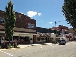 Downtown Henry | |
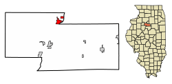 Location of Henry in Marshall County, Illinois. | |
.svg.png) Location of Illinois in the United States | |
| Coordinates: 41°6′47″N 89°21′37″W | |
| Country | United States |
| State | Illinois |
| County | Marshall |
| Area | |
| • Total | 1.82 sq mi (4.71 km2) |
| • Land | 1.75 sq mi (4.52 km2) |
| • Water | 0.07 sq mi (0.19 km2) |
| Elevation | 487 ft (148 m) |
| Population (2010) | |
| • Total | 2,464 |
| • Estimate (2018)[2] | 2,232 |
| • Density | 1,325.32/sq mi (511.58/km2) |
| Time zone | UTC-6 (CST) |
| • Summer (DST) | UTC-5 (CDT) |
| ZIP Code(s) | 61537 |
| Area code(s) | 309 |
| FIPS code | 17-34163 |
| Wikimedia Commons | Henry, Illinois |
| Website | cityofhenryil.org |
History
Henry is named after General James D. Henry, and was initially surveyed in 1834.[3] The topography of the land on the west side of the Illinois River, with relatively steep banks rising well above river level, assured early settlers that their homes would not flood.
Its slogan, "Best Town in Illinois by a Dam Site," is derived from the city's distinction of having the first lock and dam built on the Illinois River. It was completed in 1870 at a cost of $400,000.[3]
The retreat house of the Roman Catholic Diocese of Peoria, Illinois (Nazareth Retreat House, formerly, King's House) is located here.[4]
Geography
Henry is located at 41°6′47″N 89°21′37″W (41.113152, -89.360218).[5]
According to the 2010 census, Henry has a total area of 1.392 square miles (3.61 km2), of which 1.32 square miles (3.42 km2) (or 94.83%) is land and 0.072 square miles (0.19 km2) (or 5.17%) is water.[6]
Geomorphology and geology
Henry lies on a segment of a river terrace that is about 14.5 kilometers (9.0 mi) long just over 6.5 kilometers (4.0 mi) wide. This fluvial terrace is underlain by stratified; yellowish brown to grayish brown; calcareous; and usually clean and moderately well sorted sand and gravel with cobbles and boulders. These sands and gravels contain occasional beds of silt and clay and unconformably overlies older sand and gravel deposits, glacial till, or bedrock.[7] The sands and gravels underlying the terrace on which Henry lies were deposited by the Kankakee Torrent about 19,000 BP calibrated years ago.[8][9]
Within the Illinois River valley, these sediments typically range 3–24 meters (9.8–78.7 ft) thick. These and other Wisconsinan coarse-grained, fluvial sands and gravel within Illinois have been named after Henry, Illinois as and are currently known as the Henry Formation, a geological formation. The parts of the Henry Formation, which of either fluvial, glaciofluvial origin, are designated as the Mackinaw facies of the Henry Formation. The original exposure from which the Henry Formation was named was a former sand and gravel pit that once was located along Illinois Highway 29, 3.2 kilometers (2.0 mi) north of Henry[10][11]
Demographics
| Historical population | |||
|---|---|---|---|
| Census | Pop. | %± | |
| 1850 | 400 | — | |
| 1870 | 2,162 | — | |
| 1880 | 1,728 | −20.1% | |
| 1890 | 1,512 | −12.5% | |
| 1900 | 1,637 | 8.3% | |
| 1910 | 1,687 | 3.1% | |
| 1920 | 1,637 | −3.0% | |
| 1930 | 1,658 | 1.3% | |
| 1940 | 1,877 | 13.2% | |
| 1950 | 1,966 | 4.7% | |
| 1960 | 2,278 | 15.9% | |
| 1970 | 2,610 | 14.6% | |
| 1980 | 2,740 | 5.0% | |
| 1990 | 2,591 | −5.4% | |
| 2000 | 2,540 | −2.0% | |
| 2010 | 2,464 | −3.0% | |
| Est. 2018 | 2,232 | [2] | −9.4% |
| U.S. Decennial Census[12] | |||
As of the census[13] of 2000, there were 2,540 people, 1,014 households, and 678 families residing in the city. The population density was 1,821.3 people per square mile (705.5/km²). There were 1,085 housing units at an average density of 778.0 per square mile (301.4/km²). The racial makeup of the city was 97.68% White, 0.51% African American, 0.20% Native American, 0.20% Asian, 0.12% from other races, and 1.30% from two or more races. Hispanic or Latino of any race were 0.63% of the population.
There were 1,014 households out of which 29.6% had children under the age of 18 living with them, 55.2% were married couples living together, 8.2% had a female householder with no husband present, and 33.1% were non-families. 29.8% of all households were made up of individuals and 16.9% had someone living alone who was 65 years of age or older. The average household size was 2.42 and the average family size was 3.00.
In the city the population was spread out with 23.9% under the age of 18, 6.9% from 18 to 24, 24.1% from 25 to 44, 23.0% from 45 to 64, and 22.1% who were 65 years of age or older. The median age was 42 years. For every 100 females, there were 88.1 males. For every 100 females age 18 and over, there were 87.1 males.
The median income for a household in the city was $40,236, and the median income for a family was $50,375. Males had a median income of $39,919 versus $18,621 for females. The per capita income for the city was $18,473. About 5.7% of families and 5.6% of the population were below the poverty line, including 5.5% of those under age 18 and 6.3% of those age 65 or over.
Education
Henry has its own school district, Henry-Senachwine Consolidated Unit School District #5 (CUSD #5), that includes two schools.
- Henry-Senachwine Grade/Junior High School (grades kindergarten-8th)
- Henry-Senachwine High School, also referred to as HSHS (grades 9th-12th)
School mascots and colors
The two schools that make up CUSD #5 each have their own mascots: cardinals for the grade/junior high school and mallards for the high school. Both schools use red as the primary school color.
Notable people
- John P. Cromwell, World War II submarine commander who received Medal of Honor posthumously
- Richard Widmark, Actor
References
- "2016 U.S. Gazetteer Files". United States Census Bureau. Retrieved Jun 29, 2017.
- "Population and Housing Unit Estimates". Retrieved December 15, 2019.
- History of Henry, Illinois, City of Henry official site, retrieved 2007-08-15
- http://stjosephpekin.org/weekly_bulletin/121118-WeeklyBulletin.pdf%5B%5D
- "US Gazetteer files: 2010, 2000, and 1990". United States Census Bureau. 2011-02-12. Retrieved 2011-04-23.
- "G001 - Geographic Identifiers - 2010 Census Summary File 1". United States Census Bureau. Archived from the original on 2020-02-13. Retrieved 2015-12-27.
- McKay III, E.D., Berg, R.C., Stumpf, A.J. and Weibel, C.P., 2010. Surficial Geology of the Middle Illinois River Valley, Bureau, Marshall, Peoria, Putnam, and Woodford Counties, Illinois. Illinois Map 16. Scale: 1:48,000. Champaign, Illinois: Illinois State Geological Survey.
- Curry, B.B., Hajic, E.R., Clark, J.A., Befus, K.M., Carrell, J.E. and Brown, S.E., 2014. The Kankakee Torrent and other large meltwater flooding events during the last deglaciation, Illinois, USA. Quaternary Science Reviews, 90, pp.22-36.
- Wiggers, R., 1997. Geology underfoot in Illinois. Missoula, Montana: Mountain Press Publishing. pp. 127–131. ISBN 978-0-87842-346-0.
- Hansel, A.K. and Johnson, W.H., 1996. Wedron and Mason Groups: Lithostratigraphic reclassification of deposits of the Wisconsin Episode, Lake Michigan lobe area. Bulletin no. 104. Champaign, Illinois: Illinois State Geological Survey.
- Hansel, A.K., and Johnson, W.H., 2016. Henry Formation, ILSTRAT The Online Handbook of Illinois Stratigraphy, Champaign, Illinois: IllinoisState Geological Survey.
- "Census of Population and Housing". Census.gov. Retrieved June 4, 2015.
- "U.S. Census website". United States Census Bureau. Retrieved 2008-01-31.
External links
Municipalities and communities of Marshall County, Illinois, United States | ||
|---|---|---|
| Cities | Map of Illinois highlighting Marshall County | |
| Villages | ||
| Townships | ||
| Unincorporated communities |
| |
| Footnotes | ‡This populated place also has portions in an adjacent county or counties | |
| Authority control |
|
|---|