Henrhyd Falls
Henrhyd Falls (Welsh: Sgwd Henrhyd) in the Brecon Beacons National Park, Wales, is the tallest waterfall in southern Wales with a drop of 90 feet (27 m). It lies on National Trust land, in the county of Powys. The nearest settlement to it is Coelbren, on the road between Glynneath and Abercraf. Though not in the core of the area, it is considered by many to constitute a part of Wales' celebrated Waterfall Country.[1]
| Henrhyd Falls | |
|---|---|
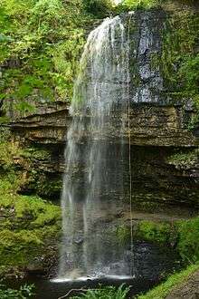 Henrhyd Waterfall. | |
| Location | Brecon Beacons National Park, Wales |
| Total height | 90 feet (27 m) |
| Watercourse | Nant Llech |
Geology
The falls occur where the small river, the Nant Llech (grid reference SN854122) drops over the faulted edge of a hard sandstone known as the Farewell Rock which forms the top half of the rock face and which forms the base of the South Wales Coal Measures. Beneath this, and forming much of the recessed portion of the drop, is the Subcrenatum Sandstone separated from the Farewell Rock above by the Subcrenatum marine band. Both the marine band and sandstone are part of the Bishopston Mudstone Formation included within the Marros Group, the modern name in South Wales for the assemblage of strata that was traditionally known as the Millstone Grit series.[2] A stream gully between the descent path and the falls marks the line of the Henrhyd Fault which is responsible for the falls' presence.[3] [4]
Access
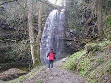
The waterfall is reached after a steep walk down into the valley from the car park established by the National Trust, and is a popular spot to visit. A further footpath leads steeply down to the falls on the opposite side of the valley from Heol Henrhyd, the road through Coelbren village. One of the area's most famous visitors was Sir William Edmond Logan (later head of the Geological Survey of Canada), who carried out detailed geological survey work in the area, discovering some 1.5km down the valley from the foot of the falls the fossil trees which now stand outside Swansea Museum.[5]
The final scene of The Dark Knight Rises was filmed at the waterfall, where it doubled as the entrance for the Batcave.
References
- Ordnance Survey Explorer map OL12 'Brecon Beacons National Park: western area'
- George, Gareth. The Geology of South Wales: a field guide (second ed.). Bearsted, Kent: Geoserv publishing. p. 164. ISBN 9780955937125.
- "Cambrian Caving Council web mapping". Cambrian Caving Council. Retrieved 31 December 2018.
- British Geological Survey 1:50,000 map sheet 231 'Merthyr Tydfil' & accompanying memoir
- George, Gareth. The Geology of South Wales: a field guide (second ed.). Bearsted, Kent: Geoserv publishing. p. 163. ISBN 9780955937125.
External links
| North Wales |
|  |
|---|---|---|
| Mid Wales | ||
| West Wales | ||
| South Wales | ||