Hay River (Canada)
The Hay River (South Slavey: Kátå’odehche) is a large river in northern Alberta and southern Northwest Territories, Canada.
| Hay River | |
|---|---|
 Hay River  | |
| Location | |
| Country | Canada |
| Physical characteristics | |
| Source | |
| ⁃ location | Northern Alberta |
| ⁃ coordinates | 58.08496°N 119.02201°W |
| ⁃ elevation | 720 metres (2,360 ft) |
| Mouth | |
⁃ location | Great Slave Lake at Hay River |
⁃ coordinates | 60.86134°N 115.73290°W |
⁃ elevation | 156 metres (512 ft) |
| Length | 702 kilometres (436 mi) |
| Basin size | 48,200 square kilometres (18,600 sq mi) |
| Discharge | |
| ⁃ average | 3,630,000 dam3 (2,940,000 acre⋅ft) |
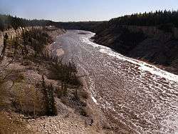
It originates in the muskeg of north western Alberta, flows west to British Columbia, then curves northward and returns to Alberta, where it follows a north-northeast course towards the Northwest Territories. After passing over two main waterfalls, the Alexandra Falls and Louise Falls, it flows through the town of Hay River and discharges into the Great Slave Lake. From there, its waters are carried to the Arctic Ocean by the Mackenzie River.
Hay River has a total length of 702 kilometres (436 mi) and a drainage area of 48,200 square kilometres (18,600 sq mi).[1]
Tributaries of the Hay River are the Chinchaga River, Meander River (in South Slavey: Tahchee), Steen River, Melvin River and Little Hay River. The Hay River effectively flows through the Hay-Zama Lakes. Rainbow Lake is a widening of the river itself.[2]
Communities in the Hay River basin include Rainbow Lake, Zama City, Steen River, Indian Cabins (in South Slavey: Dzêtú) in Alberta and Enterprise and the homonymous Hay River in the Northwest Territories. There are two first nations communities in the river basin: Chateh and Meander River.
At the Alberta – Northwest Territories border, the annual discharge is 3,630,000 cubic decametres (2,940,000 acre⋅ft).[3]
Tributaries
- Little Buffalo River
- Bivouac Creek
- Kotcho River
- Shekilie River
- White Spruce Creek
- Sahcho Creek
- Townsoitoi Creek
- Little Hay River
- Fire Creek
- Zama Lake
- Sousa Creek
- Moody Creek
- Zama River
- Omega River
- Amber River
- Mega River
- Vardie River
- Adair Creek
- Chinchaga River
- Negus Creek
- Henderson Creek
- Meander River
- Adair Creek
- Melvin River
- Slavey Creek
- Roe River
- Lutose Creek
- Little Rapids Creek
- Steen River
- Dizzy Creek
- James Creek
- Lessard Creek
- Jackpot Creek
- Swan Lake
- Goose Egg Lakes
- Swede Creek
- Twin Falls Creek
See also
References
- Atlas of Canada. "Rivers in Canada". Retrieved 2007-05-01.
- Flow North Paddling. "Trip Details". Retrieved 2012-02-03.
- Environment Alberta - River Basins Archived January 16, 2007, at the Wayback Machine
External links

| Rivers | 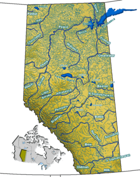 Rivers and lakes in Alberta | |
|---|---|---|
| Waterfalls | ||
| Lakes | ||
| Reservoirs | ||
| Glaciers | ||
| Other | ||