Haxby
Haxby is a small town and civil parish in the unitary authority of City of York, on the River Foss, five miles (8 km) north of York and south of Strensall, in North Yorkshire, England. Historically part of the North Riding of Yorkshire, Haxby is bordered on the east by the River Foss, and to the west by the village of Wigginton, whose expansion has caused the two settlements to form a continuous urban environment. To the south is the garden village of New Earswick and the York Outer Ring Road (A1237) with the open farmland to the north as far as the villages of Sutton-on-the-Forest and Strensall.
| Haxby | |
|---|---|
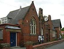
 Haxby centre | |
 Haxby Location within North Yorkshire | |
| Population | 8,428 (2011)[1] |
| OS grid reference | SE607582 |
| Civil parish |
|
| Unitary authority |
|
| Ceremonial county | |
| Region | |
| Country | England |
| Sovereign state | United Kingdom |
| Post town | YORK |
| Postcode district | YO32 |
| Dialling code | 01904 |
| Police | North Yorkshire |
| Fire | North Yorkshire |
| Ambulance | Yorkshire |
| UK Parliament | |
According to the 2001 census the parish had a population of 8,754, reducing to 8,428 at the 2011 Census.[1] Before 1996 it was part of the Ryedale district. The centre of the town was made a Conservation Area by the local council in 1976.[2]
"Haxby" is a Norse place-name and translates as "Farmstead or village of a man called Hákr". It is formed from a Norse personal name and the Old Scandinavian word bý, meaning "farmstead, village or settlement". Haxby was recorded as Haxebi in the Domesday Book of 1086. The town is primarily a dormitory for commuters to nearby towns and cities, though local service industries provide employment opportunities.[3]
History
A settlement on the site of the modern town named by the Vikings as Haxebi was established around the 9th century. The Norse word "BY" meant a township or farm and was usually appended to the name of the holder of the lands, in this case a man called Hakr. A Grade III listed Viking cross base in the churchyard of St Mary's Church, and the discovery of a Viking cross shaft in a nearby garden in 1978 support this date. There is evidence of Roman occupation with the 1966 discovery of a site of a Roman villa on Haxby Moor. Roman pottery was found in 2003 on Station Road along with a silver Roman signet ring.[2]
In the Middle Ages, because the village was in the royal Forest of Galtres, its inhabitants were subject to forest law and took part in the occasional courts that devised and enforced it. Charles I divested himself of the forest in 1629 and the village acquired the land to increase its size, resulting in the parish of some 2,100 acres (8.5 km2) of today. Haxby was not a separate parish. Initially it was divided between the parishes of Strensall and Driffield. Once St Mary's Church was built in the 16th century it became a chapelry to the parish of Strensall and in 1862 became a parish in its own right.[2]
Much of the current town centre is 18th and early 19th century architecture but significant redevelopment took place in Victorian times of which the Memorial Hall (formerly the Board School), now housing a local community radio station Vale Radio,[4] the present St Mary’s Church and the Methodist Chapel are all important buildings. It was at this time, with the arrival of the railway in Haxby, that the village became a popular place to live and commute from. Growth continued gradually throughout the first half of the 20th century until the population explosion in the 1970s quadrupled the population. In 1976, the local authority took the very important step of designating the centre of Haxby as a conservation area. By 1992 Haxby had outgrown its image of a rural village and was declared a town, by which time its population had grown to be over 10,000. At the same time, a national revision of boundaries moved Haxby from Ryedale District Council to be part of York Unitary Authority and this new authority adopted the boundaries and conditions of the conservation area.[5]
Governance
Haxby was in the Vale of York parliamentary constituency until the 2010 general election when it was transferred to the newly created constituency of York Outer. In that election the Conservative Party candidate, Julian Sturdy, was elected with 43% of the vote and a majority of 3,688 over the Liberal Democrat candidate.[6]
The town lies within the Haxby and Wigginton Ward of the York Unitary Authority. As of May 2019 it was represented by Councillors Ian Cuthbertson, Andrew Hollyer and Edward Pearson, all of whom are members of the Liberal Democrat Party.[7]
Haxby has its own Town Council, which is represented by 14 councillors from four wards.[8]
Demography
The 1881 census records the population as 559.[9] According to the 2001 census the parish had a population of 8,754, reducing to 8,428 at the 2011 Census.[1]
Geography
The town sits on flat ground consisting mostly of clay with soil that is sand and alluvium, near the old Forest of Galtres. To the north is a small tributary of the River Foss called Golland Dike, and to the east is the River Foss which flows southward.[10] The nearby village of Wigginton now merges with Haxby though the old Parish Boundary map still shows the dividing line. This runs east to west along the back of the houses on Wheatfield Drive on its southern edge as far as Barley Drive. Here it turns northward cutting across Greenshaw Drive until it reaches the road known The Village. The boundary follows this road until it turns west. The boundary at this point continues northward cutting across Windsor Drive near Ripley Grove and then out into the countryside.
Transport
As of October 2012 First York operate two bus services in the town as part of the Chapelfields to Wigginton and the Copmanthorpe to Haxby routes.[11] Yorkshire Coastliner operate the Askham Bar to Monks Cross bus services which stops in the town.[12]
These bus services are:
1: Haxby, Wigginton – City Centre – Chapelfields
13: Copmanthorpe – City Centre – Haxby (West Nooks)
20: Clifton Moor – University – Monks Cross
Between 1845 and 1930, Haxby was served by Haxby railway station on the York to Scarborough line.[13] A new station was due to open by 2013, but the plans were put on hold in June 2010 until the amount of public money necessary for the works can be clarified.[14]
Education
Primary school education is provided at Headlands Primary School in Oak Tree Lane[15] and Ralph Butterfield School in Station Road.[16] Oaken Grove Primary School (formerly Usher Lane Annex) was closed in the 2000s and the site is now a housing development.
The town is within the catchment area of Joseph Rowntree Secondary School.[17]
Sports
Haxby United Football Club play at the Ethel Ward Playing Fields. As of 2013, the 1st XI play in the York League Division 2, having won the Premier League title in the 2009/10 season.[18] The 2nd XI play in the Reserve Division A.
As of 2010 Haxby Netball Club play in the York and District Netball League, fielding two sides in Division One, two in Division Two, one in Division Three and one in Division Four.[19]
Religion
.jpg)
St Mary's Church was rebuilt in 1878 on the site of the former 16th century building with Parish Registers dating back to 1678 and is located on the road known as the Village near the centre of the town.[20] In the 19th century there was both a Wesleyan Methodist Chapel and a Primitive Methodist Chapel. As of 2010 only the Wesleyan Chapel remains as home to Haxby & Wigginton Methodist Church on the road known as the Village opposite Sandy Lane.[21][22]
St Margaret Clitherow is a Roman Catholic church located in Holly Tree Lane.[23]
See also
References
| Wikimedia Commons has media related to Haxby. |
- UK Census (2011). "Local Area Report – Haxby Parish (1170211388)". Nomis. Office for National Statistics. Retrieved 18 March 2018.
- "Conservation". Retrieved 20 November 2010.
- "Economy". Retrieved 20 November 2010.
- Marsden, Chris. "Mr". www.yorkpress.co.uk. Retrieved 29 June 2015.
- Marsden, Chris. "Mr". www.haxbytowncouncil.gov.uk. Retrieved 29 June 2015.
- "Election result". BBC News. Retrieved 20 November 2010.
- "Local councillors". Retrieved 20 November 2010.
- "Town Council". Retrieved 20 November 2010.
- Bulmer's Topography, History and Directory (Private and Commercial) of North Yorkshire 1890. S&N Publishing. 1890. ISBN 1-86150-299-0.
- "Geography". Retrieved 20 November 2010.
- "Bus Services". Retrieved 20 November 2010.
- "Bus Services". Archived from the original on 19 August 2010. Retrieved 20 November 2010.
- Butt, R. V. J. (1995). The Directory of Railway Stations: details every public and private passenger station, halt, platform and stopping place, past and present (1st ed.). Sparkford: Patrick Stephens Ltd. ISBN 978-1-85260-508-7. OCLC 60251199.
- "Site proposal for new Haxby rail station". The Press. Retrieved 1 November 2009.
- "Headlands Primary". Retrieved 20 November 2010.
- "Ralph Butterfield School". Retrieved 20 November 2010.
- "Guide to School Catchment Areas" (PDF). york.gov.uk. p. 59. Retrieved 5 December 2017.
- "Football Club". Retrieved 20 November 2010.
- "Netball". Archived from the original on 11 March 2012. Retrieved 20 November 2010.
- "St Mary's". Retrieved 20 November 2010.
- Bulmer's Topography, History and Directory (Private and Commercial) of North Yorkshire 1890. S&N Publishing. 1890. ISBN 1-86150-299-0.
- "Methodist Church". Archived from the original on 24 June 2010. Retrieved 20 November 2010.
- "Roman Catholic Church". Retrieved 20 November 2010.