Hawraman
Hawrāmān (also Húrāmān) (Kurdish: ههورامان or Hewraman) or Ūrāmān (Persian: اورامان) or Avroman[1] is a mountainous region located within the provinces of Kurdistan and Kermanshah in western Iran and in north-eastern Iraq within Iraq's Kurdistan Region. In Iran, the region includes the cities of Paveh and Mariwan and in Iraq, Halabja.
Hawraman has many springs and rivers that most their water mainly flows into Sirwan River. Bil spring (or Kani Bil) is one of these springs which has a discharge about 3000-4000 liters per second. The river which is made of Bil spring is the shortest river in the world with a total length of 15 meters.[2][3] Construction of Darian Dam on the Sirwan River between 2009 and 2015 initiated The Darian Dam Archaeological Salvage Program that led to discovery of many archaeological sites before flooding of the reservoir.
Archaeology and History
The earliest archaeological evidence shows that the region was inhabited by human since Middle Paleolithic Period. This evidence were discovered by archaeologists near Hajij village and include stone tools that made by Neanderthals or Early Modern Humans.[4] Evidence for Late Paleolithic occupation discovered in a cave site in the Perdi Mala valley.[5]

The Inscription of Sargon II at Tang-i Var pass near the village of Tang-i Var, indicate that the region was occupied by Assyrians during their military campaigns into Zagros.
The Parchments of Awraman, a set of three documents from the Seleucid and Parthian eras, were found in the region in 1909. They were discovered in a cave on Kuh-e Salan Mountain, near the village of Shar Hawraman, and subsequently sent to London.
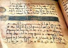
Ancient religions are also practiced throughout Hawraman and the region is home to the ancient holy places of the Yarsan faith. Some scholars believe that the name Hawraman or Huraman has strong connections to the ancient Zoroastrian faith and claim that the name may have originated from Ahuraman or Ahura Mazda.[6] Ahura Mazda is the name of God in the ancient Indo-Iranian Avestan language and comes from the ancient Zoroastrian faith, which is still being practiced by very small numbers of people in the region. Many areas in the Hawraman region are believed to have been pilgrimage sites for Zoroastrians prior to the advent of Islam.[7] One of the oldest Islamic period evidence is Negel quran. A leather-bound Quran written in the Kufic script with gilded page borders, dates to 4th century AH (913 CE – 1009 CE) which kept in the village mosque.
Wildlife
Hawraman represents the Irano-Tranian and Alpine ecozone and it has a rich fauna and flora. The wild forests of Quercus, Pistacia, Crataegus, Prannus and Amygadalus sp. are intersected by strips of deforested cultivated land.The protected area of Kosalan and Shahu is located in the Hawraman region. It was announced as protected area in 2009. The area consist of two mountain range of Shaho and Kosalan varying from some 500–800 m in altitude in the lowest valleys to 3350 m at the summits of the highest ranges. It has a cold winter with relatively high rainfall. So far, 117 species of birds, 23 species of mammals, 17 species of reptiles and 242 species of plants have been identified in this region.

Culture
The inhabitants of Hawraman are Kurdish people[8][9][10][11] that speak Hewrami, part of the Gorani branch of the Kurdish language group.[12]
Several Zazaki scholars regard Hawrami as one of the oldest dialects of the Goran–Zaza languages. According to a survey carried out by the Summer Institute of Linguistics in 1996, there were 40,000 speakers of Horami in the world.
Traditional clothing for women includes either a vest or long-sleeved jacket or long overcoat worn over a gown. An under dress and puffy pants is worn beneath the gown. Traditionally women wore Kurdish hats ornamented with valued coloured stones, beads and gold pieces. Usually younger women and young girls wear brightly coloured dresses adorned with many beads and sequins and the older women wear darker colours and white head-cover. Hawrami men generally wear a shirt; a vest with an open neck; and baggy trousers fitted at the ankles. A cotton sash 3–4 m long is folded in half lengthwise and wrapped tightly around the torso on waist. Men also wore traditional brown felt jackets with pointed shoulders called Kolabal.
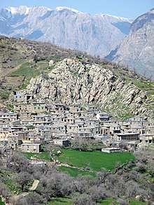
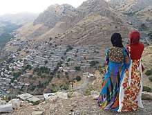
Hawraman is best known for its unique arrangement of towns and villages built along the mountain slopes of the region. Typical instances of this local architecture are Khanghah, Hajij and Shemshir villages at Kermanshah province and Hawraman Takht, Palangan, Ruwar and Selin villages at Kurdistan province.

Siyaw Chemane is a style of singing practiced by Hawrami people and means dark eyes in Hewrami. It is performed without the use of any instruments, with the exception of the occasional use of a Kurdish hand-drum or Daff. Today, the Siya Cheman style is used mostly for storytelling and entertainment.
References
- D. N. MacKenzie, Avroman, Encyclopedia Iranica
- "Kani Bil:Iranian TV; Kurdistan province". Archived from the original on 2014-08-26.
- "Rudaw:Kani Bil is in crisis". Archived from the original on 2014-08-26. Retrieved 2014-08-30.
- "Digs hint 40,000 yrs. of man life in Hawraman".
- Biglari, F and S. Shidrang (2019) Rescuing the Paleolithic Heritage of Hawraman, Kurdistan, Iranian Zagros, Near Eastern Archaeology 82 (4): 226-235.https://doi.org/10.1086/706536
- Nyberg, H.S. (1923), The Pahlavi documents of Avroman, Le Monde Oriental, XVII, p.189. This is very interesting for those interested in investigating the survival of Parthian usage of Zoroastrian terminology among the local Kurds of modern day Hawraman (Avroman).
- CHN | Tourism and Travel Archived 2008-10-10 at the Wayback Machine
- Edmonds, Cecil. Kurds, Turks, and Arabs: politics, travel, and research in northeastern Iraq, 1919-1925. Oxford University Press, 1957.
- home.hum.uva.nl/oz/leezenberg/GInflCK.pd
- "KURDISH TRIBES – Encyclopaedia Iranica". www.iranicaonline.org.
- The Kurdish National Movement: Its Origins and Development by Wadie Jwaideh page 307
- "KurdishAcademy". kurdishacademy.org.
External links
- Omid Sālehi, Customs of the Land of Stone and Wind (Ā'in-e Sar'zamin-e Sang va Bād), in Persian, Jadid Online, 5 May 2009, .
Audio slideshow: (5 min 39 sec).
Note: The place shown in the above audio slideshow is Orāmān, to the North of Pāveh. As of today (May 2009), this place has a population of approximately 3500.
| Capital |  | ||||||||||||||||||||
|---|---|---|---|---|---|---|---|---|---|---|---|---|---|---|---|---|---|---|---|---|---|
| Counties and cities |
| ||||||||||||||||||||
| Sights |
| ||||||||||||||||||||
| populated places | |||||||||||||||||||||