Hattingen
Hattingen is a town in the northern part of the Ennepe-Ruhr-Kreis district, in North Rhine-Westphalia, Germany.
Hattingen | |
|---|---|
 Aerial view | |
 Coat of arms | |
Location of Hattingen within Ennepe-Ruhr-Kreis district   | |
 Hattingen 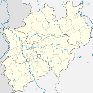 Hattingen | |
| Coordinates: 51°23′57″N 7°11′09″E | |
| Country | Germany |
| State | North Rhine-Westphalia |
| Admin. region | Arnsberg |
| District | Ennepe-Ruhr-Kreis |
| Government | |
| • Mayor | Dirk Glaser (Ind.) |
| Area | |
| • Total | 71.40 km2 (27.57 sq mi) |
| Highest elevation | 306 m (1,004 ft) |
| Lowest elevation | 60 m (200 ft) |
| Population (2018-12-31)[1] | |
| • Total | 54,562 |
| • Density | 760/km2 (2,000/sq mi) |
| Time zone | CET/CEST (UTC+1/+2) |
| Postal codes | 45525–45527–45529 |
| Dialling codes | 02324 |
| Vehicle registration | EN |
| Website | www.hattingen.de |
History
Hattingen is located on the south bank of the River Ruhr in the south of the Ruhr region. The town was first mentioned in 1396, when the Duke of Mark granted permission to build a city wall. Today, Hattingen has a picturesque historic district with Fachwerk (timber-framed houses) built between the 14th and 16th centuries. The old city is still partly surrounded by the city walls today.
There are three castles remaining within the municipal area of Hattingen.[2] Isenburg Castle was built in the 12th century in the hillsides above the Ruhr. The castle was destroyed in 1225, but prominent ruins remain. Blankenstein Castle was built in the 13th century above the Ruhr river and Haus Kemnade is a moated castle from the 16th century. All three castles are famous tourist landmarks and open to the public.
Hattingen became part of the Hanseatic League in 1554 and became an important trading town. In 1720, there were 52 operating coal mines within the municipal area and Hattingen became one of the first industrial cities of the Ruhr region. Steel production started in 1853, when the Henrichshütte was founded. The Henrichshütte became one of the most important employers of the whole region and dominated the town until it closed in 1987.
Today, Hattingen still faces problems concerning structural change of the economy, but is becoming a centre of tourism, especially its historical downtown.
Neighbouring cities

The cities bordering Hattingen are Bochum, Essen, Sprockhövel, Velbert, Witten and Wuppertal.
Division of the town
Hattingen is divided into the districts of Blankenstein, Bredenscheid-Stüter, Hattingen-Mitte, Holthausen, Niederbonsfeld, Niederelfringhausen, Niederwenigern, Oberelfringhausen, Oberstüter, Welper and Winz-Baak.
Notable persons
- Mathilde Franziska Anneke, feminist
- Erich Warsitz, world's first jet pilot
- John J. Gumperz, sociolinguist
- Harald Siepermann, Character Designer
- Marie-Luise Marjan, actress
- Jamiri (Jan-Michael Richter), comic artist
- Andreas Bieber, singer and actor
- Mirjam Müntefering, author
- Caliban (band)
- DJ Quicksilver, Disk Jockey
- Jost Gippert, German linguist
- Luke Hemmerich, German Football Player
Gallery
 Historic town
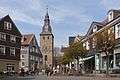 Glockenturm in the background
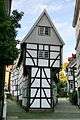 Historic Fachwerk house, the Bügeleisenhaus
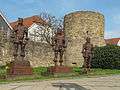 Menschen aus Eisen
References
- "Bevölkerung der Gemeinden Nordrhein-Westfalens am 31. Dezember 2018" (in German). Landesbetrieb Information und Technik NRW. Retrieved 10 July 2019.
- Historic Town Center – Hattingen Archived 2017-05-27 at the Wayback Machine Historische Stadt- & Ortskerne. Retrieved March 9, 2010
External links
| Wikimedia Commons has media related to Hattingen. |
- Official website

Towns and municipalities in Ennepe-Ruhr | ||
|---|---|---|
Coat of Arms of Ennepe-Ruhr district | ||
| Authority control |
|
|---|